
Shire of Kondinin
Encyclopedia
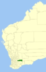
The Shire of Kondinin is a Local Government Area
in the Eastern Wheatbelt region of Western Australia
, about 300 kilometres (186 mi) east of the state capital, Perth
. The Shire's land area of 7376 square kilometres (2,848 sq mi) forms a narrow east-west band, located between the Shire of Narembeen
to the north and the Shire of Kulin
to the south. Its seat of government is the town of Kondinin
.
Local Government Areas of Western Australia
The Australian state of Western Australia is divided into 141 local government areas...
in the Eastern Wheatbelt region of Western Australia
Western Australia
Western Australia is a state of Australia, occupying the entire western third of the Australian continent. It is bounded by the Indian Ocean to the north and west, the Great Australian Bight and Indian Ocean to the south, the Northern Territory to the north-east and South Australia to the south-east...
, about 300 kilometres (186 mi) east of the state capital, Perth
Perth, Western Australia
Perth is the capital and largest city of the Australian state of Western Australia and the fourth most populous city in Australia. The Perth metropolitan area has an estimated population of almost 1,700,000....
. The Shire's land area of 7376 square kilometres (2,848 sq mi) forms a narrow east-west band, located between the Shire of Narembeen
Shire of Narembeen
The Shire of Narembeen is a Local Government Area in the Eastern Wheatbelt region of Western Australia, about east of the state capital, Perth, and between the shires of Merredin to the north, and Kondinin to the south...
to the north and the Shire of Kulin
Shire of Kulin
The Shire of Kulin is a Local Government Area in the Eastern Wheatbelt region of Western Australia, about ESE of the state capital, Perth. The Shire's land area of forms a narrow east-west band, located between the Shire of Kondinin to the north and the Shire of Lake Grace to the south. Its seat...
to the south. Its seat of government is the town of Kondinin
Kondinin, Western Australia
Kondinin is a town located in the Eastern Wheatbelt region of Western Australia, east of the state capital, Perth via the Brookton Highway and State Route 40 between Corrigin and Hyden. It is the main town in the Shire of Kondinin...
.
History
The Kondinin Road Board was formed from the portions of the Roe Road Board, Corrigin Road Board and Narembeen Road Board on 19 June 1925. The first election was held on 5 September 1925, with the first meeting taking place in the Kondinin Hall a week later. On 1 July 1961, it became the Shire Council following changes to the Local Government Act.Wards
The shire was previously divided into 4 wards, however these were abolished in 2004. All 8 councillors sit at large.Towns and localities
- BenderingBendering, Western AustraliaBendering is a town located between Kondininand Narembeen in the eastern Wheatbelt region of Western Australia.The town was gazetted in 1921. The name of the town is taken from a nearby spring and is Aboriginal in origin, its meaning is unknown....
- HydenHyden, Western AustraliaThe town of Hyden is located 339 km east of Perth, Western Australia in the Shire of Kondinin. Hyden is home to Wave Rock and Mulka's Cave, both popular local tourist attractions....
- KondininKondinin, Western AustraliaKondinin is a town located in the Eastern Wheatbelt region of Western Australia, east of the state capital, Perth via the Brookton Highway and State Route 40 between Corrigin and Hyden. It is the main town in the Shire of Kondinin...
- KarlgarinKarlgarin, Western AustraliaKarlgarin is a town located 321 km south east of Perth in the eastern Wheatbelt region of Western Australia.Th first European to visit the area was Surveyor General John Septimus Roe who passed through in 1848. He recorded the name "Carlgarin" as the name of a nearby hill...