
Shire of Murray
Encyclopedia
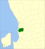
The Shire of Murray is a Local Government Area
of Western Australia
. It covers an area of 1711 square kilometres (661 sq mi) just beyond metropolitan Perth
, the capital of Western Australia. It lies about 80 km south of the Perth central business district
. The Shire of Murray had a population of 11,969 as at the 2006 census.
Local Government Areas of Western Australia
The Australian state of Western Australia is divided into 141 local government areas...
of Western Australia
Western Australia
Western Australia is a state of Australia, occupying the entire western third of the Australian continent. It is bounded by the Indian Ocean to the north and west, the Great Australian Bight and Indian Ocean to the south, the Northern Territory to the north-east and South Australia to the south-east...
. It covers an area of 1711 square kilometres (661 sq mi) just beyond metropolitan Perth
Perth, Western Australia
Perth is the capital and largest city of the Australian state of Western Australia and the fourth most populous city in Australia. The Perth metropolitan area has an estimated population of almost 1,700,000....
, the capital of Western Australia. It lies about 80 km south of the Perth central business district
Central business district
A central business district is the commercial and often geographic heart of a city. In North America this part of a city is commonly referred to as "downtown" or "city center"...
. The Shire of Murray had a population of 11,969 as at the 2006 census.
History
The Murray Road Board was gazetted in December 1887. On 1 July 1961, it became the Shire of Murray.Wards
The shire has been divided into 6 wards.- Pinjarra Ward (3 councillors)
- North West Ward (2 councillors)
- North Ward (1 councillor)
- West Ward (4 councillors)
- South Ward (1 councillor)
- East Ward (1 councillor)
Suburbs and towns
Bold denotes major settlements
|
Fairbridge, Western Australia Fairbridge, Western Australia is a former farm school and locality near Pinjarra in south west Western Australia.-Kingsley Fairbridge:On 15 April 1912, Kingsley and Ruby Fairbridge arrived in Albany, Western Australia, from England and made their way to Pinjarra, arriving on 16 July that same year... Furnissdale, Western Australia Furnissdale is a locality near Mandurah, Western Australia, located to the south of Pinjarra Road situated near the Serpentine River entrance into the Peel Inlet within the Shire of Murray. Its postcode is 6210... Keralup, Western Australia Keralup is a suburb straddling the southern boundary of the metropolitan area of Perth, Western Australia, on the eastern side of the Kwinana Freeway, and consists entirely of a government strategic landholding... Meelon, Western Australia Meelon is a small townsite in the Peel region of Western Australia, located between Pinjarra and Dwellingup within the Shire of Murray. At the 2006 census, Meelon had a population of 557.... |
Nambeelup, Western Australia Nambeelup is a small town and dormitory suburb of the city of Mandurah in the Peel Region of Western Australia.Named after Nambeelup Brook, it is of a predominantly rural land use although it is home to several residential and industrial subdivisions through the St Davids development which, due to... Nirimba, Western Australia Nirimba is a rural locality in the Shire of Murray in the Peel Region of Western Australia, located directly south of the Austin Cove development in South Yunderup.... North Dandalup, Western Australia North Dandalup is a small town in the Peel region of Western Australia along the South Western Highway between Serpentine and Pinjarra. Its local government area is the Shire of Murray... North Yunderup, Western Australia North Yunderup is a locality near Mandurah, Western Australia, located on the north bank of the Murray River within the Shire of Murray. Its postcode is 6208, and in the 2006 Census, it had a population of 792 with a median age of 44, nearly all of whom live in separate dwellings.... Oakley, Western Australia Oakley is a locality in the Peel Region of Western Australia. Its local government area is the Shire of Murray.Oakley is located at the foot of the Darling Scarp and is very lowly populated, it is one of the locations of Alcoa's three alumina refineries, which is named after the nearest large town... Pinjarra, Western Australia Pinjarra is a town in the Peel region of Western Australia along the South Western Highway, from the state capital, Perth and south-east of the coastal city of Mandurah. Its local government area is the Shire of Murray. At the 2006 census, Pinjarra had a population of 3,279.Pinjarra is an area... (seat) |
Ravenswood, Western Australia Ravenswood in a small town in the Peel region of Western Australia.The town is located along Pinjarra Road and on the banks of the Murray River... South Yunderup, Western Australia South Yunderup is a township near Mandurah, Western Australia, located on the south bank of the Murray River within the Shire of Murray. Its postcode is 6208, and in the 2006 Census, it had a population of 1,965 with a median age of 50... Stake Hill, Western Australia Stake Hill is a northeastern rural residential suburb of Mandurah, Western Australia. Its Local Government Area is the Shire of Murray. At the 2006 census, Stake Hill had a population of 670.-History:... West Pinjarra, Western Australia West Pinjarra is a suburb of the town of Pinjarra in the Peel Region of Western Australia. Its local government area is the Shire of Murray.... |
Population
| Year | Population |
|---|---|
| 1911 | 2,199 |
| 1921 | 3,400 |
| 1933 | 4,060 |
| 1947 | 4,118 |
| 1954 | 3,897 |
| 1961 | 3,592 |
| 1966 | 3,329 |
| 1971 | 4,061 |
| 1976 | 5,035 |
| 1981 | 6,306 |
| 1986 | 6,634 |
| 1991 | 8,157 |
| 1996 | 9,144 |
| 2001 | 10,035 |
| 2006 | 11,969 |
- At the 1954 census, Mandurah, which had seceded from Murray, had a population of 1,687.