
Shire of Brookton
Encyclopedia
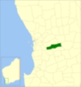
The Shire of Brookton is a Local Government Area located in the Wheatbelt region of Western Australia
, about 140 kilometres (87 mi) southeast of Perth
, the state capital. The Shire covers an area of 1602 square kilometres (619 sq mi) and its seat of government is the town of Brookton
.
The local economy, worth approximately $25 million per year to the state economy, is based on agriculture - predominantly cereal grains and sheep.
. On 1 July 1961, it became the Shire of Brookton under the Local Government Act 1960.
Western Australia
Western Australia is a state of Australia, occupying the entire western third of the Australian continent. It is bounded by the Indian Ocean to the north and west, the Great Australian Bight and Indian Ocean to the south, the Northern Territory to the north-east and South Australia to the south-east...
, about 140 kilometres (87 mi) southeast of Perth
Perth, Western Australia
Perth is the capital and largest city of the Australian state of Western Australia and the fourth most populous city in Australia. The Perth metropolitan area has an estimated population of almost 1,700,000....
, the state capital. The Shire covers an area of 1602 square kilometres (619 sq mi) and its seat of government is the town of Brookton
Brookton, Western Australia
Brookton is a town located in the Wheatbelt region of Western Australia, Australia, from the state capital, Perth via the Brookton Highway where it crosses the Great Southern Highway. The town is also located on the Great Southern railway line. It is located within, and is the seat of government...
.
The local economy, worth approximately $25 million per year to the state economy, is based on agriculture - predominantly cereal grains and sheep.
History
On 10 September 1906, the Brookton Road Board met for the first time after Mr Samuel Williams led a move by local landowners to break away from the Beverley Road DistrictShire of Beverley
The Shire of Beverley is a Local Government Area located in the Wheatbelt region of Western Australia, and is about southeast of Perth, the state capital. The Shire covers an area of , starting outside Armadale in the Darling Scarp and extending eastwards beyond the scarp into agricultural lands...
. On 1 July 1961, it became the Shire of Brookton under the Local Government Act 1960.
Wards
The shire presently is undivided and has 7 councillors. Prior to the 2009 local government election, it was divided into three wards as follows:- Central Ward (5 councillors)
- West Ward (2 councillors)
- East Ward (2 councillors)
Towns
- AldersydeAldersyde, Western AustraliaAldersyde is a small town located in the Wheatbelt region of Western Australia, about east of the town of Brookton.-History:Land for a proposed townsite at the 18½ mile peg on the Brookton-Kunjin Railway was resumed from four properties in 1913...
- BrooktonBrookton, Western AustraliaBrookton is a town located in the Wheatbelt region of Western Australia, Australia, from the state capital, Perth via the Brookton Highway where it crosses the Great Southern Highway. The town is also located on the Great Southern railway line. It is located within, and is the seat of government...
- Jelcobine
- KwedaKweda, Western AustraliaKweda is a small town located in the Wheatbelt region of Western Australia, about east of the town of Brookton.-History:The government was planning to build a railway line between Brookton and Kunjin Kweda is a small town located in the Wheatbelt region of Western Australia, about east of the...
- Nalya
Population
| Year | Population |
|---|---|
| 1921 | 1,149 |
| 1933 | 1,188 |
| 1947 | 934 |
| 1954 | 1,376 |
| 1961 | 1,319 |
| 1966 | 1,341 |
| 1971 | 1,272 |
| 1976 | 1,181 |
| 1981 | 1,214 |
| 1986 | 1,093 |
| 1991 | 1,018 |
| 1996 | 908 |
| 2001 | 957 |
| 2006 | 978 |