
Shire of Beverley
Encyclopedia
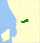
The Shire of Beverley is a Local Government Area
located in the Wheatbelt region of Western Australia
, and is about 130 kilometres (80.8 mi) southeast of Perth
, the state capital. The Shire covers an area of 2372 square kilometres (916 sq mi), starting 20 kilometres (12 mi) outside Armadale
in the Darling Scarp
and extending eastwards beyond the scarp into agricultural lands which support broad acre activities such as livestock and cropping. Its seat of government is the town of Beverley
, which accommodates just over half of the Shire's population.
on the South Australia
n border. Its scope was so broad that from 1892 to 1913, the town of Beverley had its own municipal council operating separately from the Road Board. However, over the years, each of the major towns were granted their own road boards, and by 1923 the present boundaries were established. In 1961, the Road District was renamed to the Shire of Beverley.
Prior to 1986, the Shire was represented by 8 councillors across 4 wards which had existed in some form since the amalgamation of the Municipal District in 1913:
Local Government Areas of Western Australia
The Australian state of Western Australia is divided into 141 local government areas...
located in the Wheatbelt region of Western Australia
Western Australia
Western Australia is a state of Australia, occupying the entire western third of the Australian continent. It is bounded by the Indian Ocean to the north and west, the Great Australian Bight and Indian Ocean to the south, the Northern Territory to the north-east and South Australia to the south-east...
, and is about 130 kilometres (80.8 mi) southeast of Perth
Perth, Western Australia
Perth is the capital and largest city of the Australian state of Western Australia and the fourth most populous city in Australia. The Perth metropolitan area has an estimated population of almost 1,700,000....
, the state capital. The Shire covers an area of 2372 square kilometres (916 sq mi), starting 20 kilometres (12 mi) outside Armadale
Armadale, Western Australia
Armadale is a suburb within the City of Armadale, located on the south-eastern edge of Perth's metropolitan area. The major junction of the South Western and Albany Highways, which connect Perth with the South West and Great Southern regions of Western Australia respectively, is located within the...
in the Darling Scarp
Darling Scarp
The Darling Scarp, also referred to as the Darling Range or Darling Ranges, is a low escarpment running north-south to the east of the Swan Coastal Plain and Perth, Western Australia...
and extending eastwards beyond the scarp into agricultural lands which support broad acre activities such as livestock and cropping. Its seat of government is the town of Beverley
Beverley, Western Australia
Beverley is a town located in the Wheatbelt region of Western Australia, south-east of the state capital, Perth, between York and Brookton on the Great Southern Highway...
, which accommodates just over half of the Shire's population.
History
In 1871, the Beverley Road District was established with immense boundaries, taking in land all the way east to EuclaEucla, Western Australia
Eucla is the easternmost locality in Western Australia, located in the Goldfields-Esperance region of Western Australia along the Eyre Highway, approximately west of the South Australian border...
on the South Australia
South Australia
South Australia is a state of Australia in the southern central part of the country. It covers some of the most arid parts of the continent; with a total land area of , it is the fourth largest of Australia's six states and two territories.South Australia shares borders with all of the mainland...
n border. Its scope was so broad that from 1892 to 1913, the town of Beverley had its own municipal council operating separately from the Road Board. However, over the years, each of the major towns were granted their own road boards, and by 1923 the present boundaries were established. In 1961, the Road District was renamed to the Shire of Beverley.
Wards
The shire has been divided into three wards, which became effective on 2 May 1987.- North Ward (3 councillors)
- West Ward (3 councillors)
- South Ward (3 councillors)
Prior to 1986, the Shire was represented by 8 councillors across 4 wards which had existed in some form since the amalgamation of the Municipal District in 1913:
- Kokeby Ward
- North East Ward
- Central Ward
- Dale Ward
Towns
- BeverleyBeverley, Western AustraliaBeverley is a town located in the Wheatbelt region of Western Australia, south-east of the state capital, Perth, between York and Brookton on the Great Southern Highway...
- Flint
- Mount KokebyMount Kokeby, Western AustraliaMount Kokeby is a small town located in the Wheatbelt region of Western Australia, about south of the town of Beverley towards Brookton.-History:...
- Mount DaleMount DaleMount Dale is a mountain in Western Australia. It is located at , about 25 km east of Armadale in the Shire of Beverley. At 546 m high, it is one of the highest points in the Darling Scarp....
- Talbot West
- West DaleWest Dale, Western AustraliaWestdale or West Dale is a small town located just of the Beverley-Westdale road 93 km from Perthin the Wheatbelt region of Western Australia....
Population
| Year | Population |
|---|---|
| 1921 | 1,882 |
| 1933 | 1,992 |
| 1947 | 1,629 |
| 1954 | 1,968 |
| 1961 | 1,899 |
| 1966 | 1,773 |
| 1971 | 1,628 |
| 1976 | 1,577 |
| 1981 | 1,554 |
| 1986 | 1,502 |
| 1991 | 1,433 |
| 1996 | 1,399 |
| 2001 | 1,461 |
| 2006 | 1,562 |