
Shio no Michi
Encyclopedia
Kaido
were ancient roads in Japan dating from the Edo period. Major examples include the Edo Five Routes, all of which started at Edo...
in ancient Japan
Japan
Japan is an island nation in East Asia. Located in the Pacific Ocean, it lies to the east of the Sea of Japan, China, North Korea, South Korea and Russia, stretching from the Sea of Okhotsk in the north to the East China Sea and Taiwan in the south...
and was used to transport salt from the ocean to the inland portions of central Honshū
Honshu
is the largest island of Japan. The nation's main island, it is south of Hokkaido across the Tsugaru Strait, north of Shikoku across the Inland Sea, and northeast of Kyushu across the Kanmon Strait...
. In the Middle Ages, salt was brough both from the Sea of Japan
Sea of Japan
The Sea of Japan is a marginal sea of the western Pacific Ocean, between the Asian mainland, the Japanese archipelago and Sakhalin. It is bordered by Japan, North Korea, Russia and South Korea. Like the Mediterranean Sea, it has almost no tides due to its nearly complete enclosure from the Pacific...
and the Pacific Ocean
Pacific Ocean
The Pacific Ocean is the largest of the Earth's oceanic divisions. It extends from the Arctic in the north to the Southern Ocean in the south, bounded by Asia and Australia in the west, and the Americas in the east.At 165.2 million square kilometres in area, this largest division of the World...
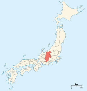
to Shinano Province
Shinano Province
or is an old province of Japan that is now present day Nagano Prefecture.Shinano bordered on Echigo, Etchū, Hida, Kai, Kōzuke, Mikawa, Mino, Musashi, Suruga, and Tōtōmi Provinces...
for processing. The road leading from the Sea of Japan to Shinano Province was called the Chikuni Kaidō (千国街道), whereas the road leading from the Pacific Ocean was called the Sanshū Kaidō (三州街道).
Stations of the Chikuni Kaidō
On the Echigo ProvinceEchigo Province
was an old province in north-central Japan, on the shores of the Sea of Japan. It was sometimes called , with Echizen and Etchū Provinces. Today the area is part of Niigata Prefecture, which also includes the island which was the old Sado Province. This province was the northernmost part of the...
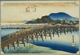
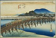
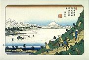
side of the route, it was called the Itoigawa Kaidō, but on the Shinano Province side, it was called Chikuni Kaidō. The Sawado-juku and Sano-juku pair and the Ida-juku and Imori-juku pair each essentially functioned as one post station
Shukuba
were post stations during the Edo period in Japan, generally located on one of the Edo Five Routes or one of its sub-routes. They were also called shukueki . These post stations were places where travelers could rest on their journey around the nation...
.
Niigata Prefecture
- 1. Itoigawa-juku (糸魚川宿) (ItoigawaItoigawa, Niigatais a city located in rustic southern Niigata Prefecture, Japan.As of 2008, the city has an estimated population of 48,653 and the density of 65.2 persons per km². The total area is 746.24 km².The city was founded on June 1, 1954...
) - 2. Yamaguchi-juku (山口宿) (Itoigawa)
Nagano Prefecture
- 3. Ōami-juku (大網宿) (OtariOtari, Naganois a village located in Kitaazumi District, Nagano, Japan.As of 2003, the village has an estimated population of 4,122 and a density of 15.39 persons per km². The total area is 267.91 km².-External links:*...
) - 4. Kuruma-juku (来馬宿) (Otari)
- 5. Chikuni-juku (千国宿) (Otari)
- 6. Shiojima Shinden-juku (塩島新田宿) (HakubaHakuba, Naganois a village located in Kitaazumi District, Nagano, Japan.-Town:As of 2007, the village has an estimated population of 9,246 and a density of 50.71 persons per km². The total area is 182.34 km²....
) - 7. Iida-juku (飯田宿) and Iimori-juku (飯森宿) (Hakuba)
- 8. Sawado-juku (沢度宿) and Sano-juku (佐野宿) (Hakuba)
- 9. Uminokuchi-juku (海ノ口宿) (ŌmachiOmachi, Naganois a city located in Nagano, Japan.As of 2008, the city has an estimated population of 31,079 and the population density of 55 persons per km². The total area is 564.99 km²....
) - 10. Ōmachi-juku (大町宿) (Ōmachi)
- 11. Ikeda-juku (池田宿) (IkedaIkeda, Naganois a town located in Kitaazumi District, Nagano, Japan.As of 2003, the town has an estimated population of 10,647 and a density of 264.98 persons per km². The total area is 40.18 km².-External links:*...
) - 12. Hotaka-juku (保高宿) (AzuminoAzumino, Naganois a city located in Nagano Prefecture, Japan.The city was founded on October 1, 2005, when the town of Akashina, from Higashichikuma District, and the towns of Hotaka and Toyoshina, and the villages of Horigane and Misato, from Minamiazumi District, merged to form a new city...
) - 13. Nariai Shinden-juku (成相新田宿) (Azumino)
- 14. Matsumoto-juku (松本宿) (MatsumotoMatsumoto, Naganois a city located in Nagano Prefecture, Japan. Matsumoto is designated as a Special City.-Outline:The new city of Matsumoto is the city comprising the mergers of the old city of Matsumoto and four villages. Matsumoto officially absorbed those villages without creating a new municipal...
)
Stations of the Sanshū Kaidō
Mikawa Bay
thumb|right|Mikawa Bay Mikawa Bay is a bay to the south of Aichi Prefecture, Japan, surrounded by Chita Peninsula to the west and Atsumi Peninsula to the east and south. Its area is approximately 604 km2...
by boats traveling up the Yahagi River
Yahagi River
The is a river that flows from Nagano Prefecture's Mount Ōkawairi, through Gifu Prefecture, and enters Mikawa Bay from Aichi Prefecture in Japan. It is one of Japan's first-class rivers.-Geography:...
and its tributary, the Tomoe River. From Toyota
Toyota, Aichi
is a city located in the Mikawa region of Aichi Prefecture, Japan, east of Nagoya.Toyota's main plant, the Tsutsumi plant, is located here. The longstanding ties between the Toyota Motor Corporation and the town of Toyota-shi, formerly known as Koromo, gave the town its current...
, it was carried by horse, marking the start of the Sanshū Kaidō.
Aichi Prefecture
- 1. Okazaki-shukuOkazaki-shukuwas the thirty-eighth of the fifty-three stations of the Tōkaidō. It is located in the present-day city of Okazaki, in Aichi Prefecture, Japan.-History:...
(岡崎宿) (OkazakiOkazaki, Aichiis a city located in Aichi Prefecture, Japan. As of August 2011, the city had an estimated population of 373,339 and a population density of 964 persons per km². The total area was 387.24 km².-Geography:...
) (also part of the TōkaidōTokaido (road)The ' was the most important of the Five Routes of the Edo period, connecting Edo to Kyoto in Japan. Unlike the inland and less heavily travelled Nakasendō, the Tōkaidō travelled along the sea coast of eastern Honshū, hence the route's name....
) - 2. Kugyūdaira-juku (九久平宿) (ToyotaToyota, Aichiis a city located in the Mikawa region of Aichi Prefecture, Japan, east of Nagoya.Toyota's main plant, the Tsutsumi plant, is located here. The longstanding ties between the Toyota Motor Corporation and the town of Toyota-shi, formerly known as Koromo, gave the town its current...
) - 3. Asuke-juku (足助宿) (Toyota)
- 4. Busetsu-juku (武節宿) (Toyota)
Nagano Prefecture
- 5. Neba-juku (根羽宿) (NebaNeba, Naganois a village located in Shimoina District, Nagano Prefecture, Japan.As of 2003, the village has an estimated population of 1,289 and a density of 14.33 persons per km². The total area is 89.95 km².- History :...
) - 6. Hiraya-juku (平谷宿) (HirayaHiraya, Naganois a village located in Shimoina District, Nagano, Japan.As of 2003, the village has an estimated population of 645 and a density of 8.33 persons per km²...
) - 7. Namiai-juku (浪合宿) (NamiaiNamiai, Naganowas a village located in Shimoina District, Nagano, Japan.On January 1, 2006, Namiai was merged into the village of Achi.As of 2003, the village had an estimated population of 766 and a density of 13.38 persons per km². The total area was 57.24 km²....
) - 8. Komaba-juku (駒場宿) (AchiAchi, Naganois a village located in Shimoina District, Nagano, Japan.Achi was the birthplace of the photographer and illustrator Motoichi Kumagai, who worked as a teacher in the village and photographed its life; the village has a permanent gallery of Kumagai's work, Kumagai Motoichi Shashin Dōgakan.On March...
) - 9. Iida-juku (飯田宿) (IidaIida, Naganois a city located in southern Nagano Prefecture, Japan.Located on the Iida Line, an old local train line that runs through the valley of the Tenryū River in the southern Japan Alps, Iida lies 90 minutes northeast of the major city of Nagoya by automobile via the Chūō Expressway...
) - 10. Ichida-juku (市田宿) (TakamoriTakamori, Naganois a town located in Shimoina District, Nagano, Japan.As of 2003, the town has an estimated population of 12,838 and a density of 283.65 persons per km². The total area is 45.26 km².-External links:*...
) - 11. Ōjima-juku (大島宿) (Matsukawa)
- 12. Katabora-juku (片桐宿) (Matsukawa)
- 13. Iijima-juku (飯島宿) (IijimaIijima, Naganois a town located in Kamiina District, Nagano, Japan. It is bordered by Nakagawa to the east, Komagane to the north, Ōkuwa to the west, and Matsukawa and Iida to the south....
) - 14. Akazu Uwabu-juku (赤須上穂宿) (KomaganeKomagane, Naganois a city located in Nagano, Japan.As of 2003, the city has an estimated population of 34,409 and the density of 207.38 persons per km². The total area is 165.92 km²....
) - 15. Miyada-juku (宮田宿) (MiyadaMiyada, Naganois a village located in Kamiina District, Nagano, Japan.As of 2003, the village has an estimated population of 8,870 and a density of 162.69 persons per km². The total area is 54.52 km²....
) - 16. Inabe-juku (伊那部宿) (InaIna, Naganois a city located in Nagano, Japan.The city was founded on March 31, 2006 when the old city of Ina merged with the town of Takatō and the village of Hase, both from Kamiina District, to form the new city of Ina.-Surrounding municipalities:*Nagano Prefecture...
) - 17. Matsujima-juku (松島宿) (MinowaMinowa, Naganois a town located in Kamiina District, Nagano, Japan.As of 2009, the town has an estimated population of 25,983 and a density of 302 persons per km²...
) - 18. Miyagi-juku (宮木宿) (TatsunoTatsuno, Naganois a town located in Kamiina District, Nagano, Japan.As of 2003, the town has an estimated population of 22,312 and a density of 132.01 persons per km². The total area is 169.02 km². The altitude is 723 m.-Geography:...
) - 19. Ono-juku (小野宿) (ShiojiriShiojiri, Naganois a city located in Nagano, Japan. Its name literally means "the end of salt".-History:Municipal Area Changes* April 1, 1927-The village of Shiojiri gained town status....
) - 20. Shiojiri-shukuShiojiri-shukuwas the thirtieth of the sixty-nine stations of the Nakasendō. It is located in the central part of the present-day city of Shiojiri, Nagano Prefecture, Japan.-History:This area was originally built by Ōkubo Nagayasu in the Keichō era of the early Edo period...
(塩尻宿) (Shiojiri) (also part of the NakasendōNakasendoThe , also called the , was one of the five routes of the Edo period, and one of the two that connected Edo to Kyoto in Japan. There were 69 stations between Edo and Kyoto, crossing through Musashi, Kōzuke, Shinano, Mino and Ōmi provinces...
)