
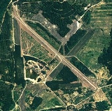
Sharpe Field
Encyclopedia
Airport
An airport is a location where aircraft such as fixed-wing aircraft, helicopters, and blimps take off and land. Aircraft may be stored or maintained at an airport...
located six nautical miles (11 km) northwest of the central business district
Central business district
A central business district is the commercial and often geographic heart of a city. In North America this part of a city is commonly referred to as "downtown" or "city center"...
of Tuskegee
Tuskegee, Alabama
Tuskegee is a city in Macon County, Alabama, United States. At the 2000 census the population was 11,846 and is designated a Micropolitan Statistical Area. Tuskegee has been an important site in various stages of African American history....
, a city in Macon County
Macon County, Alabama
Macon County is a county in the U.S. state of Alabama. Its name is in honor of Nathaniel Macon, a member of the United States Senate from North Carolina. Developed for cotton plantation agriculture in the nineteenth century, it is one of the counties in Alabama within the Black Belt of the South.As...
, Alabama
Alabama
Alabama is a state located in the southeastern region of the United States. It is bordered by Tennessee to the north, Georgia to the east, Florida and the Gulf of Mexico to the south, and Mississippi to the west. Alabama ranks 30th in total land area and ranks second in the size of its inland...
, United States
United States
The United States of America is a federal constitutional republic comprising fifty states and a federal district...
. This airport is privately owned by the Bradbury Family Partnership.
Formerly known as Tuskegee Army Airfield, Sharpe Field was to used train the Tuskegee Airmen
Tuskegee Airmen
The Tuskegee Airmen is the popular name of a group of African American pilots who fought in World War II. Formally, they were the 332nd Fighter Group and the 477th Bombardment Group of the U.S. Army Air Corps....
during World War II
World War II
World War II, or the Second World War , was a global conflict lasting from 1939 to 1945, involving most of the world's nations—including all of the great powers—eventually forming two opposing military alliances: the Allies and the Axis...
. It provided advanced training for the graduates of nearby Moton Field. Most of the history of the Tuskegee Airmen was made at this site.
History
The Air Field was designed by the African American architect Hilyard RobinsonHilyard Robinson
Hilyard R. Robinson was a renowned African-American modernist architect known for his work in designing public housing.-Life:A native Washingtonian, Robinson studied at the prestigious M Street High School, Philadelphia's School of Industrial Design, the University of Pennsylvania School of...
and built in 1941. Construction began on July 12, 1941. Training flights began in November of the same year, even though construction was nowhere near completion. A graded (but not yet paved) portion of the north/south runway was used to conduct initial flight training.
The earliest depiction of the Tuskegee AAF airfield which has been located was on the August 1942 14M Regional Aeronautical Chart (courtesy of Chris Kennedy). It depicted “Tuskegee” as a commercial or municipal airport.
Tuskegee AAF was assigned to the Southeast Training Center of the Army Air Force Training Command. It was commanded by the 318th Army Air Force Base Unit. By the end of 1942, Tuskegee had a total of 3,414 personnel. The March 1943 14M Regional Aeronautical Chart labeled the airfield as “Tuskegee Army Flying School”, and indicated that the field had a control tower. By September 1943, Tuskegee had 4 runways & a total of 225 buildings.
Aircraft used at Tuskegee during World War II included the PT-17 biplane basic trainer, BT-13 monoplane advanced trainer, AT-6 Texan advanced trainer, and P-40 Warhawk (used for fighter transition training).
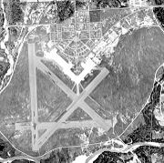
Twin-engine training commenced at Tuskegee in 1943, at first using the AT-10. The 1944 US Army/Navy Directory of Airfields described Tuskegee AAF as having a 5,000' hard-surface runway As constructed during World War II, Tuskegee AAF consisted of 4 asphalt runways (the longest being 5,200'), taxiways, a ramp, and a large number of buildings north of the field
During World War II, Tuskegee AAF had 2 satellite airfields: Griel Auxiliary #1, and Shorter Auxiliary #2 (still in use today as Shorter Airport). These 2 auxiliary airfield were not depicted on the November 1944 Birmingham Sectional Chart but they did appear on the April 1945 Birmingham Sectional Chart. The 1945 Birmingham Sectional Chart also depicted a "Tuskegee Institute #1" airfield, a few miles southeast of the town of Tuskegee, but no trace has been identified of this airfield on recent aerial photos.
The AT-10 twin-engine trainer was replaced at Tuskegee by the TB-25 Mitchell in 1945. The last pilot class graduated at Tuskegee in 1946, bringing the total number of pilots trained at the base to 992.
Tuskegee AAF was inactivated in 1946, and the property reverted back to the town of Tuskegee. Many of the base's buildings were moved into the town, and 2 of the hangars were relocated.
Although the 1962 Birmingham Sectional Chart depicted Sharpe Field as having 4 paved runways (with the longest being 5,000'), the Aerodromes table included the remark "North/South only usable runway."
Sharpe Field was reopened as a civilian airport at some point between 1945–62, as that is how it was listed in the 1962 AOPA Airport Directory. Sharpe Field was described as having a single 5,000' asphalt Runway 18/36, and the operator was listed as Sharpe Aviation Service
The Tuskegee airfield was evidently closed once again at some point between 1965–71, as it was not listed among active airfields in the 1971 Flight Guide.
In 1976, an attempt was made to reuse the abandoned base as an oil refinery, but this did not work out. It was depicted as an abandoned airfield on the 1998 World Aeronautical Chart.
The site of Tuskegee AAF was purchased by the Bradbury Family Partnership in the year 2000 time frame. It is strictly a private development, however, in 2003 that Sharpe Field was once again listed as an active private airfield. Only one runway was listed as being active, the 5,300' asphalt Runway 14/32. The owner was listed as the Bradbury Family Partnership, of Woodstock, GA.
The purpose of the airfield having been reactivated is unknown, although the old ramp area was used as an asphalt plant for a number of years. Some of the equipment can still be seen on the ramp area.
Facilities
Sharpe Field covers an area of 2600 acres (1,052.2 ha) at an elevationElevation
The elevation of a geographic location is its height above a fixed reference point, most commonly a reference geoid, a mathematical model of the Earth's sea level as an equipotential gravitational surface ....
of 253 feet (77 m) above mean sea level. It has one asphalt
Asphalt
Asphalt or , also known as bitumen, is a sticky, black and highly viscous liquid or semi-solid that is present in most crude petroleums and in some natural deposits, it is a substance classed as a pitch...
paved runway
Runway
According to ICAO a runway is a "defined rectangular area on a land aerodrome prepared for the landing and take-off of aircraft." Runways may be a man-made surface or a natural surface .- Orientation and dimensions :Runways are named by a number between 01 and 36, which is generally one tenth...
designated 14/32 which measures 5,300 by 46 feet (1,615 x 14 m).