
Sgurr nan Ceannaichean
Encyclopedia
Scotland
Scotland is a country that is part of the United Kingdom. Occupying the northern third of the island of Great Britain, it shares a border with England to the south and is bounded by the North Sea to the east, the Atlantic Ocean to the north and west, and the North Channel and Irish Sea to the...
mountain situated 13 kilometres south west of Achnasheen
Achnasheen
Achnasheen is a small village in Ross-shire in the Highland council area of Scotland. Despite the size of the village, Achnasheen is also the name of a postal district which covers several much larger communities. This dates from the time when the village railway station was an important stop on...
on the southern side of Glen Carron within the Glencarron and Glenuig Forest in the Ross and Cromarty
Ross and Cromarty
Ross and Cromarty is a variously defined area in the Highlands and Islands of Scotland. There is a registration county and a lieutenancy area in current use...
district of the Highland
Highland (council area)
Highland is a council area in the Scottish Highlands and is the largest local government area in both Scotland and the United Kingdom as a whole. It shares borders with the council areas of Moray, Aberdeenshire, Perth and Kinross, and Argyll and Bute. Their councils, and those of Angus and...
council area.
Overview
The mountains name translates from the GaelicScottish Gaelic language
Scottish Gaelic is a Celtic language native to Scotland. A member of the Goidelic branch of the Celtic languages, Scottish Gaelic, like Modern Irish and Manx, developed out of Middle Irish, and thus descends ultimately from Primitive Irish....
as Peak of the Merchants or Pedlars. The reason for this name may be that in the past the main route between east and west Scotland went by the valley of Strathconan just to the north and Sgurr nan Ceannaichean may have been seen as a significant landmark by traders and travellers.
Initially classed as a Corbett, Sgurr nan Ceannaichean was reclassified as a Munro
Munro
A Munro is a mountain in Scotland with a height over . They are named after Sir Hugh Munro, 4th Baronet , who produced the first list of such hills, known as Munros Tables, in 1891. A Munro top is a summit over 3,000 ft which is not regarded as a separate mountain...
in 1981 after Ordnance Survey surveys completed in the late 1970s assigned a height of 915 metres. In 2009, survey by The Munro Society assigned a new height of 913.43 metres to Sgurr nan Ceannaichean, thus demoting it back to the status of Corbett.
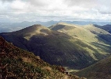
Geography
Sgurr nan Ceannaichean is a much more interesting hill than the adjoining Munro of MoruisgMòruisg
Mòruisg is a Scottish mountain situated in the Glencarron and Glenuig Forest, 10 kilometres south west of the village of Achnasheen in the Highland council area.-Overview:...
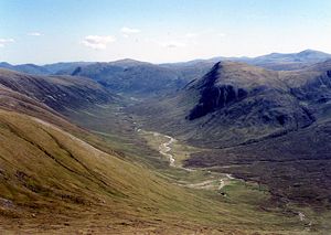
, its western flank is very steep and craggy as it falls to the valley of the Allt a’ Chonais and contains two deep and impressive gullies. The fine corrie
Cirque
Cirque may refer to:* Cirque, a geological formation* Makhtesh, an erosional landform found in the Negev desert of Israel and Sinai of Egypt*Cirque , an album by Biosphere* Cirque Corporation, a company that makes touchpads...
of Coire Toll nam Bian stands on the north eastern side of the mountain while another lesser corrie, Coire an Tuill Bhàn, lies just east of the summit and descends south east to the valley near Glenuig Lodge. The highest point of the mountain lies on a plateau with a number of cairn
Cairn
Cairn is a term used mainly in the English-speaking world for a man-made pile of stones. It comes from the or . Cairns are found all over the world in uplands, on moorland, on mountaintops, near waterways and on sea cliffs, and also in barren desert and tundra areas...
s with the most southerly one being the highest point. The mountain stands on the main Scottish east-west watershed
Water divide
A drainage divide, water divide, divide or watershed is the line separating neighbouring drainage basins...
with most of the drainage going to Glen Carron and the sea at the west coast. However the eastern slopes form the head waters of the River Meig which takes water to the Cromarty Firth
Cromarty Firth
The Cromarty Firth of Cromarty') is an arm of the North Sea in Scotland. It is the middle of the three sea lochs at the head of the Moray Firth: to the north lies the Dornoch Firth, and to the south the Beauly Firth....
on the east coast of Scotland.