

Selby Canal
Encyclopedia
The Selby Canal is a 6 miles (9.7 km) canal with 2 locks which bypasses the lower reaches of the River Aire
in Yorkshire
, England
, from the village of West Haddlesey to the town of Selby
where it joins the River Ouse
. It opened in 1778, and provided the main outlet for the Aire and Calder Navigation until 1826, when it was bypassed by a new cut from Ferrybridge to Goole. Selby steadily declined after that, although traffic to York still used the canal.
Powers to increase its depth were obtained in 1828, and the residents of Selby used legal action to ensure that the company complied with its own Act of Parliament
. The locks were enlarged in 1885, and subsequent history was uneventful, with the canal eventually coming under the control of British Waterways in 1962. When British Waterways also took control of the River Ouse, the canal was marketed as part of a through route to York
, and the number of boats using it have steadily increased. Although not originally part of the canal, the section of the Aire from Dole Bank Lock to Haddlesey Flood Lock is usually considered to be part of the modern Selby Canal, making it 11.7 miles (18.8 km) long with four locks.
, and there were several schemes to bypass part or all of it. John Longbotham was employed by some of the backers for the Leeds and Liverpool Canal
to survey a route from Leeds to Selby, although the Leeds and Selby Canal was not officially supported by the Leeds and Liverpool undertaking. The canal would have been just over 23 miles (37 km) long, with ten locks, a ten-arched aqueduct over the River Aire
at Hunslet
, and a 400 yards (365.8 m) tunnel at Fairburn. The estimated cost of £59,468 was raised in two months, and a bill
was presented to Parliament in December 1772, as was another by the Aire and Calder Navigation for improvements to the Aire below Haddlesey. The Parliamentary committee found a number of issues with the Leeds and Selby scheme, and generally favoured improvements to the Aire, but no decision was made on either proposal.
Following the impasse, the Aire and Calder decided that a route to Selby might be a better solution than improvements to the lower Aire, and William Jessop
, working for John Smeaton
, surveyed a route that ran from Haddlesey to Selby, which would require a lock at Selby, where the canal joined the River Ouse, and floodgates at Haddlesey. By the spring of 1774, the Leeds and Selby Canal was supported by the Leeds and Liverpool company, and rival bills were presented to Parliament. The Leeds and Selby proposal was defeated, but the Aire and Calder bill became an Act of Parliament
on 14 June 1774.
The company employed Jessop as engineer on a part-time basis, with John Gott acting as the resident engineer. James and John Pinkerton were the main contractors, and construction began in early 1775. A great celebration was held at Selby on 29 April 1778, when the canal opened, having cost £20,000. The town of Selby flourished following the opening, with a custom house which enabled traffic to proceed straight to the North Sea without stopping at Hull. While the canal was fairly successful, there were some problems. There was a 2 miles (3.2 km) section where the banks consisted of loose sand, which had to be regularly dredged to prevent the sand blocking it, and Elias Wright, who was the engineer in 1797, complained that the depth of only 3.5 feet (1.1 m) was too shallow, and that extra boards had to be kept on Haddlesey weir to maintain the water levels. As cargoes increased the canal became too shallow for the larger barges.
Prior to the building of the canal, Selby had been the furthest point upstream on the Ouse which could be reached by seagoing ships. Although some of the barges which used the canal travelled up the Ouse to York or down to the Humber
Ports and the River Trent
, this traffic was mainly restricted to coal, and other cargoes were transhipped at Selby. The larger Humber keel
s, sloops, schooners and brigs, some of 200 tons, carried the goods further afield. By 1800, some 369,780 tons were being handled, and industries such as ropemaking, sailmaking and shipbuilding thrived. In the twenty years from 1801 to 1821, the population of Selby increased from 2,861 to 4,097. Dividends paid by the Aire and Calder Navigation showed a large increase, from £11,625 in 1777 to £32,000 in 1791, much of which was funded by the increase in miscellaneous goods, including wool, bales of cloth and groceries, which the Selby Canal had promoted.
Of the trade above Haddlesey, around four-fifths travelled via Selby, with the rest using the lower Aire. The engineer George Leather, writing in 1822, noted that the route to Goole via Selby was much better than the lower Aire, but that it still suffered from problems. These included the size and depth of the canal, the provision of only one lock between the canal and the river, and that there were no docks at Selby, suitable for the brigs and other vessels that used the river. Meanwhile, the Aire and Calder were facing the prospect of rival schemes to provide canals parallel to the rivers. The Aire and Dun Canal was proposed in 1817, to run from Knottingley to Newbridge on the Dutch River, with a branch to Doncaster
on the River Don Navigation
, while the Went and Wakefield Canal would join the Barnsley Canal at Cold Hiendley to the River Don above Newbridge. To head off the competition, the Aire and Calder proposed a new cut from Knottingley to Goole, which included the provision of a cut at Bank Dole to maintain the connection to the Selby Canal. A petition was presented to Parliament in late 1819, and as a result of opposition, clauses were inserted to maintain the lower Aire and the Selby Canal, and to ensure parity of tolls on the new cut and the old routes.
Further improvements to the Calder route to Wakefield were designed by Thomas Telford
, while George Leather redesigned the Aire route to Leeds. The changes would allow 100-ton boats to reach both destinations, and became part of an Act of Parliament which was obtained on 19 June 1828. This act included a provision to increase the navigable depth of the Selby Canal to 5 feet (1.5 m), which the company hoped to achieve by raising the dam boards on the weirs at Haddlesey and Beal. They knew that this was not actually legal, and a case brought before the Quarter Sessions upheld this position, so they started to make the channel wider and deeper. However, the residents of Selby were not satisfied, and further legal action by them resulted in the company having to carry out additional work in 1832 and 1833. The work included the provision of a new lock into the Ouse, as the old one was in a poor state of repair. Traders at Malton and York petitioned for the canal to be made deeper still in 1833, but their request was turned down. The partially derelict wharf wall at Selby was replaced in 1836, allowing fully laden ships to moor alongside it.
, which lasted until 1840, when the railway from Selby to Hull opened. Lengthening of the locks on the main Aire and Calder lines to take compartment boats
was completed by 1873, and the locks on the Selby line were rebuilt between 1885 and 1886. This work included Dole Bank Lock and Beal Lock, on the old course of the Aire, as well as Haddlesey Flood Lock and Selby Lock. The locks were made 78.5 by, and the navigable depth was increased to 6 feet (1.8 m). The Aire and Calder remained highly successful, although little is heard of the Selby Canal after 1900.
In January 1948, private ownership of the canal ceased, when it was taken over by the British Transport Commission, as part of the post-war nationalisation. Several changes followed, until the British Waterways Board took control in 1962, later to become British Waterways
.
 Prior to 1985, the River Ouse between Goole and above York was managed by the Ouse and Foss Navigation Trust, but was later transferred to British Waterways. The Selby Canal was then promoted as part of a through route to York, and by 2006, over 2000 boats were using Selby Lock each year, more than double the number recorded in 1988. Today the canal is used almost entirely by leisure boats. Part of the towpath has been included in the Selby Horseshoe Walk.
The canal takes boats with a maximum length of 78.5 feet (23.9 m), a beam of 16.5 feet (5 m), a draught of 4 feet (1.2 m) and an air draught of 9.7 feet (3 m). Although not historically part of the Selby Canal, the former section of the River Aire from Bank Dole Junction through Bank Dole Lock and Beal Lock to the flood lock at West Haddlesey is now normally considered to be part of the canal, giving it a total length of 11.7 miles (18.8 km) and four locks. Because the River Ouse at Selby is tidal, the lock can only be used at certain states of the tide, and a lockkeeper is in attendance when a transit into the river is possible. Operation of the lock is fully mechanised.
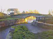
Shortly after the lock, the canal is crossed by Tankard's Stone Bridge, and then by Paper House Bridge. This is a late-eighteenth century single arched humpback bridge, made of millstone grit, and is grade II listed. The East Coast Main Line
crosses next, after which comes Burton Hall Bridge, an accommodation bridge designed by William Jessop, and constructed when the canal was built. The A19 road
crosses at Burn Bridge, and a dismantled railway used to cross just to the south of the A63 road
bridge. Immediately afterwards, another original bridge carries Brayton Lane across the canal. Then the Doncaster to Selby railway line crosses at Brayton Railway Bridge, and the A1041 road at Bawtry Road Bridge. The only swing bridge is situated just before the final lock, and is operated by boaters. A wider section marks the point at which the wharves and dry dock turned along the quayside. Both the lock, which retains some paddle mechanisms from 1828 and the adjacent lock house, which has six bays and a hipped pantile roof, are grade II listed structures.
River Aire
The River Aire is a major river in Yorkshire, England of length . Part of the river is canalised, and is known as the Aire and Calder Navigation....
in Yorkshire
Yorkshire
Yorkshire is a historic county of northern England and the largest in the United Kingdom. Because of its great size in comparison to other English counties, functions have been increasingly undertaken over time by its subdivisions, which have also been subject to periodic reform...
, England
England
England is a country that is part of the United Kingdom. It shares land borders with Scotland to the north and Wales to the west; the Irish Sea is to the north west, the Celtic Sea to the south west, with the North Sea to the east and the English Channel to the south separating it from continental...
, from the village of West Haddlesey to the town of Selby
Selby
Selby is a town and civil parish in North Yorkshire, England. Situated south of the city of York, along the course of the River Ouse, Selby is the largest and, with a population of 13,012, most populous settlement of the wider Selby local government district.Historically a part of the West Riding...
where it joins the River Ouse
River Ouse, Yorkshire
The River Ouse is a river in North Yorkshire, England. The river is formed from the River Ure at Cuddy Shaw Reach near Linton-on-Ouse, about 6 miles downstream of the confluence of the River Swale with the River Ure...
. It opened in 1778, and provided the main outlet for the Aire and Calder Navigation until 1826, when it was bypassed by a new cut from Ferrybridge to Goole. Selby steadily declined after that, although traffic to York still used the canal.
Powers to increase its depth were obtained in 1828, and the residents of Selby used legal action to ensure that the company complied with its own Act of Parliament
Act of Parliament
An Act of Parliament is a statute enacted as primary legislation by a national or sub-national parliament. In the Republic of Ireland the term Act of the Oireachtas is used, and in the United States the term Act of Congress is used.In Commonwealth countries, the term is used both in a narrow...
. The locks were enlarged in 1885, and subsequent history was uneventful, with the canal eventually coming under the control of British Waterways in 1962. When British Waterways also took control of the River Ouse, the canal was marketed as part of a through route to York
York
York is a walled city, situated at the confluence of the Rivers Ouse and Foss in North Yorkshire, England. The city has a rich heritage and has provided the backdrop to major political events throughout much of its two millennia of existence...
, and the number of boats using it have steadily increased. Although not originally part of the canal, the section of the Aire from Dole Bank Lock to Haddlesey Flood Lock is usually considered to be part of the modern Selby Canal, making it 11.7 miles (18.8 km) long with four locks.
History
In the late 1760s, there was dissatisfaction with the state of the Aire and Calder NavigationAire and Calder Navigation
The Aire and Calder Navigation is a river and canal system of the River Aire and the River Calder in the metropolitan county of West Yorkshire, England. The first improvements to the rivers above Knottingley were completed in 1704 when the Aire was made navigable to Leeds and the Calder to...
, and there were several schemes to bypass part or all of it. John Longbotham was employed by some of the backers for the Leeds and Liverpool Canal
Leeds and Liverpool Canal
The Leeds and Liverpool Canal is a canal in Northern England, linking the cities of Leeds and Liverpool. Over a distance of , it crosses the Pennines, and includes 91 locks on the main line...
to survey a route from Leeds to Selby, although the Leeds and Selby Canal was not officially supported by the Leeds and Liverpool undertaking. The canal would have been just over 23 miles (37 km) long, with ten locks, a ten-arched aqueduct over the River Aire
River Aire
The River Aire is a major river in Yorkshire, England of length . Part of the river is canalised, and is known as the Aire and Calder Navigation....
at Hunslet
Hunslet
Hunslet is an inner-city area in south Leeds, West Yorkshire, England. It is south east of the city centre and has an industrial past.Hunslet had many engineering companies based in the district, such as John Fowler & Co...
, and a 400 yards (365.8 m) tunnel at Fairburn. The estimated cost of £59,468 was raised in two months, and a bill
Bill (proposed law)
A bill is a proposed law under consideration by a legislature. A bill does not become law until it is passed by the legislature and, in most cases, approved by the executive. Once a bill has been enacted into law, it is called an act or a statute....
was presented to Parliament in December 1772, as was another by the Aire and Calder Navigation for improvements to the Aire below Haddlesey. The Parliamentary committee found a number of issues with the Leeds and Selby scheme, and generally favoured improvements to the Aire, but no decision was made on either proposal.
Following the impasse, the Aire and Calder decided that a route to Selby might be a better solution than improvements to the lower Aire, and William Jessop
William Jessop
William Jessop was an English civil engineer, best known for his work on canals, harbours and early railways in the late 18th and early 19th centuries.-Early life:...
, working for John Smeaton
John Smeaton
John Smeaton, FRS, was an English civil engineer responsible for the design of bridges, canals, harbours and lighthouses. He was also a capable mechanical engineer and an eminent physicist...
, surveyed a route that ran from Haddlesey to Selby, which would require a lock at Selby, where the canal joined the River Ouse, and floodgates at Haddlesey. By the spring of 1774, the Leeds and Selby Canal was supported by the Leeds and Liverpool company, and rival bills were presented to Parliament. The Leeds and Selby proposal was defeated, but the Aire and Calder bill became an Act of Parliament
Act of Parliament
An Act of Parliament is a statute enacted as primary legislation by a national or sub-national parliament. In the Republic of Ireland the term Act of the Oireachtas is used, and in the United States the term Act of Congress is used.In Commonwealth countries, the term is used both in a narrow...
on 14 June 1774.
The company employed Jessop as engineer on a part-time basis, with John Gott acting as the resident engineer. James and John Pinkerton were the main contractors, and construction began in early 1775. A great celebration was held at Selby on 29 April 1778, when the canal opened, having cost £20,000. The town of Selby flourished following the opening, with a custom house which enabled traffic to proceed straight to the North Sea without stopping at Hull. While the canal was fairly successful, there were some problems. There was a 2 miles (3.2 km) section where the banks consisted of loose sand, which had to be regularly dredged to prevent the sand blocking it, and Elias Wright, who was the engineer in 1797, complained that the depth of only 3.5 feet (1.1 m) was too shallow, and that extra boards had to be kept on Haddlesey weir to maintain the water levels. As cargoes increased the canal became too shallow for the larger barges.
Development
The new route provided a better route from Leeds and Wakefield to Hull, although it was a similar length to the route via the lower Aire, but considerably reduced the distance from Leeds to York. The port at Airmyn on the lower Aire closed in early 1779, and 8 acres (3.2 ha) of land were leased at Selby, on which to build port facilities and warehouses. Staithes were build in 1781 and 1782, and 1782 also saw the construction of a counting house, a warehouse, a rigging house, a tarring house, a sailmaker's shop, a crane and a repository for old ropes. Two cranes were erected in 1787, one on the canal and the other on the river, while an extra lock-keeper had to be employed in 1788 because of the volume of trade. Ten years later, John Foster built a private dry dock at Selby, where many of the boats of the Aire and Calder were repaired.Prior to the building of the canal, Selby had been the furthest point upstream on the Ouse which could be reached by seagoing ships. Although some of the barges which used the canal travelled up the Ouse to York or down to the Humber
Humber
The Humber is a large tidal estuary on the east coast of Northern England. It is formed at Trent Falls, Faxfleet, by the confluence of the tidal River Ouse and the tidal River Trent. From here to the North Sea, it forms part of the boundary between the East Riding of Yorkshire on the north bank...
Ports and the River Trent
River Trent
The River Trent is one of the major rivers of England. Its source is in Staffordshire on the southern edge of Biddulph Moor. It flows through the Midlands until it joins the River Ouse at Trent Falls to form the Humber Estuary, which empties into the North Sea below Hull and Immingham.The Trent...
, this traffic was mainly restricted to coal, and other cargoes were transhipped at Selby. The larger Humber keel
Humber Keel
The Humber Keel was a type of sail craft used for inshore and inland cargo transport around Hull and the Humber Estuary, in the United Kingdom, particularly through the late 19th and early 20th centuries....
s, sloops, schooners and brigs, some of 200 tons, carried the goods further afield. By 1800, some 369,780 tons were being handled, and industries such as ropemaking, sailmaking and shipbuilding thrived. In the twenty years from 1801 to 1821, the population of Selby increased from 2,861 to 4,097. Dividends paid by the Aire and Calder Navigation showed a large increase, from £11,625 in 1777 to £32,000 in 1791, much of which was funded by the increase in miscellaneous goods, including wool, bales of cloth and groceries, which the Selby Canal had promoted.
Of the trade above Haddlesey, around four-fifths travelled via Selby, with the rest using the lower Aire. The engineer George Leather, writing in 1822, noted that the route to Goole via Selby was much better than the lower Aire, but that it still suffered from problems. These included the size and depth of the canal, the provision of only one lock between the canal and the river, and that there were no docks at Selby, suitable for the brigs and other vessels that used the river. Meanwhile, the Aire and Calder were facing the prospect of rival schemes to provide canals parallel to the rivers. The Aire and Dun Canal was proposed in 1817, to run from Knottingley to Newbridge on the Dutch River, with a branch to Doncaster
Doncaster
Doncaster is a town in South Yorkshire, England, and the principal settlement of the Metropolitan Borough of Doncaster. The town is about from Sheffield and is popularly referred to as "Donny"...
on the River Don Navigation
River Don Navigation
The River Don Navigation was the result of early efforts to make the River Don in South Yorkshire, England, navigable between Fishlake and Sheffield...
, while the Went and Wakefield Canal would join the Barnsley Canal at Cold Hiendley to the River Don above Newbridge. To head off the competition, the Aire and Calder proposed a new cut from Knottingley to Goole, which included the provision of a cut at Bank Dole to maintain the connection to the Selby Canal. A petition was presented to Parliament in late 1819, and as a result of opposition, clauses were inserted to maintain the lower Aire and the Selby Canal, and to ensure parity of tolls on the new cut and the old routes.
Competition
An Act of Parliament to authorise the new route and other works was obtained on 30 June 1820. The plans developed, with a basin and locks at Goole being added in 1821, and an increase in the navigable depth from 6 feet (1.8 m) to 7 feet (2.1 m) soon afterwards. John Rennie, the engineer for the project, died in 1821, and the following year George Leather, who took over this role, revealed plans for a ship dock at Goole, while in 1824 the start of the new cut was moved to Ferrybridge. Although a boat carrying directors travelled from Ferrybridge to Goole on 28 July 1825, the canal was not then complete. Opening eventually took place on 20 July 1826, partly due to a drought which delayed the filling of the cut. Boats could still reach the Selby Canal by using the Dole Bank Lock. The Aire and Calder company began to use Goole rather than Selby as the destination for all of their craft, and gradually hauliers and boat captains moved to the new location, resulting in a steady decline at Selby.Further improvements to the Calder route to Wakefield were designed by Thomas Telford
Thomas Telford
Thomas Telford FRS, FRSE was a Scottish civil engineer, architect and stonemason, and a noted road, bridge and canal builder.-Early career:...
, while George Leather redesigned the Aire route to Leeds. The changes would allow 100-ton boats to reach both destinations, and became part of an Act of Parliament which was obtained on 19 June 1828. This act included a provision to increase the navigable depth of the Selby Canal to 5 feet (1.5 m), which the company hoped to achieve by raising the dam boards on the weirs at Haddlesey and Beal. They knew that this was not actually legal, and a case brought before the Quarter Sessions upheld this position, so they started to make the channel wider and deeper. However, the residents of Selby were not satisfied, and further legal action by them resulted in the company having to carry out additional work in 1832 and 1833. The work included the provision of a new lock into the Ouse, as the old one was in a poor state of repair. Traders at Malton and York petitioned for the canal to be made deeper still in 1833, but their request was turned down. The partially derelict wharf wall at Selby was replaced in 1836, allowing fully laden ships to moor alongside it.
Decline
Although most traffic on the Aire and Calder now passed through Goole, trade with York continued to use the Selby Canal. The town of Selby declined, although there was a brief upturn in its fortunes in 1834, following the opening of the Leeds and Selby RailwayLeeds and Selby Railway
The Leeds and Selby Railway was an early British railway company and first mainline railway in Yorkshire. It was opened in 1834.The company was absorbed by the York and North Midland Railway and the line remained in use through the subsequent NER, LNER, BR and post-privatisation periods.As of 2010...
, which lasted until 1840, when the railway from Selby to Hull opened. Lengthening of the locks on the main Aire and Calder lines to take compartment boats
Tom Pudding
Tom Pudding was the name given to the tub boats on the Aire and Calder Navigation, introduced in 1863 and used until 1985, which were a very efficient means of transferring and transporting coal from the open cast collieries of the South Yorkshire Coalfield near Stanley Ferry to the port of Goole,...
was completed by 1873, and the locks on the Selby line were rebuilt between 1885 and 1886. This work included Dole Bank Lock and Beal Lock, on the old course of the Aire, as well as Haddlesey Flood Lock and Selby Lock. The locks were made 78.5 by, and the navigable depth was increased to 6 feet (1.8 m). The Aire and Calder remained highly successful, although little is heard of the Selby Canal after 1900.
In January 1948, private ownership of the canal ceased, when it was taken over by the British Transport Commission, as part of the post-war nationalisation. Several changes followed, until the British Waterways Board took control in 1962, later to become British Waterways
British Waterways
British Waterways is a statutory corporation wholly owned by the government of the United Kingdom, serving as the navigation authority in England, Scotland and Wales for the vast majority of the canals as well as a number of rivers and docks...
.
Leisure age
The canal takes boats with a maximum length of 78.5 feet (23.9 m), a beam of 16.5 feet (5 m), a draught of 4 feet (1.2 m) and an air draught of 9.7 feet (3 m). Although not historically part of the Selby Canal, the former section of the River Aire from Bank Dole Junction through Bank Dole Lock and Beal Lock to the flood lock at West Haddlesey is now normally considered to be part of the canal, giving it a total length of 11.7 miles (18.8 km) and four locks. Because the River Ouse at Selby is tidal, the lock can only be used at certain states of the tide, and a lockkeeper is in attendance when a transit into the river is possible. Operation of the lock is fully mechanised.
Route
From the main Ferrybridge to Goole cut on the Aire and Calder Canal, a short branch leaves the main channel near Knottingley, and a lock drops the level by 7 feet (2.1 m) into the River Aire, which flows in a big loop at this point. The river follows a meandering course to Beal, where a bridge carries Intake Lane over it, and a large weir drops the level by another 8 feet (2.4 m). Beal Lock is to the right of the weir, and is 2.8 miles (4.5 km) from the start of this section. After a further 3.7 miles (6 km), the Aire continues straight ahead, and there is a sharp left turn into Haddlesey Flood Lock and the start of the Selby Canal. The river section is marked by high flood banks. Haddlesey Lock is normally open unless there are high volumes of water passing down the Aire.Shortly after the lock, the canal is crossed by Tankard's Stone Bridge, and then by Paper House Bridge. This is a late-eighteenth century single arched humpback bridge, made of millstone grit, and is grade II listed. The East Coast Main Line
East Coast Main Line
The East Coast Main Line is a long electrified high-speed railway link between London, Peterborough, Doncaster, Wakefield, Leeds, York, Darlington, Newcastle and Edinburgh...
crosses next, after which comes Burton Hall Bridge, an accommodation bridge designed by William Jessop, and constructed when the canal was built. The A19 road
A19 road
The A19 is a major road in England running approximately parallel to and east of the A1 road, although the two roads meet at the northern end of the A19, the two roads originally met at the southern end of the A19 in Doncaster but the old route of the A1 was changed to the A638. From Sunderland...
crosses at Burn Bridge, and a dismantled railway used to cross just to the south of the A63 road
A63 road
The A63 is a major road in Yorkshire, England between Leeds and Hull.-Leeds – Howden:The route out to Selby is shadowed by the Leeds-Selby railway....
bridge. Immediately afterwards, another original bridge carries Brayton Lane across the canal. Then the Doncaster to Selby railway line crosses at Brayton Railway Bridge, and the A1041 road at Bawtry Road Bridge. The only swing bridge is situated just before the final lock, and is operated by boaters. A wider section marks the point at which the wharves and dry dock turned along the quayside. Both the lock, which retains some paddle mechanisms from 1828 and the adjacent lock house, which has six bays and a hipped pantile roof, are grade II listed structures.
Points of interest
See also
- Canals of the United KingdomCanals of the United KingdomThe canals of the United Kingdom are a major part of the network of inland waterways in the United Kingdom. They have a colourful history, from use for irrigation and transport, through becoming the focus of the Industrial Revolution, to today's role for recreational boating...
- History of the British canal systemHistory of the British canal systemThe British canal system of water transport played a vital role in the United Kingdom's Industrial Revolution at a time when roads were only just emerging from the medieval mud and long trains of pack horses were the only means of "mass" transit by road of raw materials and finished products The...