
Sedona, Arizona
Encyclopedia
Sedona is a city that straddles the county line between Coconino
and Yavapai
counties in the northern Verde Valley
region of the U.S. state of Arizona
. Although according to 2005 Census Bureau estimates, the population of the city was 11,220, the 2010 Census revealed a population of 10,031.
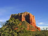
Sedona's main attraction is its stunning array of red sandstone
formations, the Red Rocks of Sedona. The formations appear to glow in brilliant orange and red when illuminated by the rising or setting sun. The Red Rocks form a breathtaking backdrop for everything from spiritual pursuits to the hundreds of hiking and mountain biking trails.
Sedona is named after Sedona Arabelle Miller Schnebly (1877–1950), the wife of the city's first postmaster, who was celebrated for her hospitality and industriousness.
of northern Arizona. At an elevation of 4,500 feet (1,372 m), Sedona has mild winters and summers.
According to the United States Census Bureau
, the city has a total area of 18 square miles (46.6 km²), nearly all of it land.
The famous red rocks of Sedona are formed by a layer of rock known as the Schnebly Hill Formation. The Schnebly Hill Formation is a thick layer of red to orange-colored sandstone
found only in the Sedona vicinity. The sandstone, a member of the Supai Group, was deposited during the Permian Period.
, 0.49% Black
or African American
, 0.45% Native American
, 0.94% Asian
, 0.09% Pacific Islander
, 4.29% from other races
, and 1.57% from two or more races. 8.90% of the population were Hispanic
or Latino
of any race.
At the 2000 census there were 7,229 people living in the Yavapai County (western) portion of the city (70.9% of its population) and 2,963 living in the Coconino County (eastern) portion (29.1%). By land area Yavapai had 66.2% of its area, versus 33.8% for Coconino.
There were 4,928 households out of which 15.8% had children under the age of 18 living with them, 48.6% were married couples living together, 6.6% had a female householder with no husband present, and 41.9% were non-families. 32.2% of all households were made up of individuals and 14.2% had someone living alone who was 65 years of age or older. The average household size was 2.06 and the average family size was 2.52.
In the city the population was spread out with 13.7% under the age of 18, 4.5% from 18 to 24, 21.2% from 25 to 44, 35.0% from 45 to 64, and 25.6% who were 65 years of age or older. The median age was 50 years. For every 100 females there were 88.1 males. For every 100 females age 18 and over, there were 85.9 males.
The median income for a household in the city was $44,042, and the median income for a family was $52,659. Males had a median income of $32,067 versus $24,453 for females. The per capita income
for the city was $31,350. About 4.7% of families and 9.7% of the population were below the poverty line, including 12.1% of those under age 18 and 5.0% of those age 65 or over.
in 1876, to the San Carlos Indian Reservation, 180 miles southeast. 1500 people were marched, in midwinter, to San Carlos. Several hundred lost their lives. The survivors were interned for 25 years. About 200 Yavapai and Apache people returned to the Verde Valley in 1900 and have since intermingled as a single political entity although culturally distinct.
in 1876. The early settlers were farmers and ranchers. Oak Creek Canyon was well-known for its peach and apple orchards. In 1902, when the Sedona post office was established, there were 55 residents. In the mid-1950s, the first telephone directory listed 155 names. Parts of the Sedona area weren't electrified until the 1960s.
Sedona began to develop as a tourist destination, vacation-home and retirement center in the 1950s. Most of the development seen today was constructed in the 1980s and 1990s. As of 2007, there are no large tracts of undeveloped land remaining.
, was completed. Inspired by the architecture of the Empire State Building
, this chapel appears to rise 250 feet out of a thousand foot red rock formation characteristic of Sedona. The sunset strikes the chapel from the front, naturally lighting the chapel in the evening.
 Politically, Uptown Sedona, the Gallery District and the Chapel area (all in Coconino County) and West Sedona (in Yavapai County) form the City of Sedona. Originally founded in 1902, the town was incorporated into a city in January 1988. The unincorporated Village of Oak Creek, seven miles (11 km) to the south and well outside the Sedona city limits, is a significant part of the Sedona community.
Sedona’s Hollywood legacy offers nothing less than a time line of history—of moviemaking in America and the popular culture of the years that shaped it. The story begins in the silent era, when Zane Grey’s The Call of the Canyon and Kit Carson, with Joseph P. Kennedy’s doomed movie superstar Fred Thomson, were filmed in the Oak Creek Canyon area just outside Sedona proper. The 1930s saw the arrival of a dozen B westerns, including four visits from silent film idol turned talkie cowboy star George O’Brien and the only Hopalong Cassidy film ever shot outside California. The decade also saw Sedona cast in her most historically significant movie role, as the promised land of milk and honey in Der Kaiser von Kalifornien, a Nazi western designed to validate Adolf Hitler’s schemes of territorial expansion to the people of Germany.
When John Ford’s production of Stagecoach pulled into town in 1938 (a Sedona connection that has eluded historians since the film was made), it set off three solid decades of A-picture activity—forty-four features through 1973, helped along by the construction of Sedona Lodge, the only permanent boarding and production facility ever built specifically for movie crews on remote location in the United States. During those years, many of Hollywood’s biggest names were photographed in front of Sedona’s signature landscape, from Errol Flynn to Gene Tierney, John Wayne to Joan Crawford, James Stewart to Lizabeth Scott, Robert Mitchum to Elvis Presley.
Sedona (which promoted itself as "Arizona's Little Hollywood") wasn’t only a cinematic romping ground for cowboys. In the years that followed World War II, shadows darkened the scenery to add psychological complexity to a number of early film noir dramas, like Leave Her to Heaven, while at the same time a secret battle involving blacklisted Broken Arrow screenwriter Albert Maltz, a prominent member of the “Hollywood Ten”—the victims of the anti-communist witch hunts that came to symbolize America’s Cold War paranoia—was being fought on the same dusty ground.
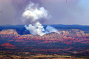 On June 18, 2006, a wildfire, reportedly started by campers, began about one mile (1.6 km) north of Sedona. The so-called "Brins Fire" covered 4317 acres (17 km²) on Brins Mesa, Wilson Mountain and in Oak Creek Canyon
before the USDA Forest Service declared it 100% contained on June 28. Containment cost was estimated at $6,400,000.
Sedona is home to several notable arts organizations in Northern Arizona
.
Verde Valley School
, a boarding International Baccalaureate high school with many international students, is located between the Village of Oak Creek and Red Rock Crossing. It hosts numerous 'traditions' and performances open to the community. The mascot is the coyote. Total attendance measures about 120 students per year, grades 9-12, Monday through Friday.
Sedona Red Rock High School (SRRHS), built in 1994, is located on the western edge of town in West Sedona. The school's mascot is the Scorpion. The high school's new campus, a series of single story buildings, is located opposite the Sedona campus of Yavapai College
.
Sedona Charter School (SCS), is located behind the Sedona Public Library, serving as a Montessori based school for grades K-8.
Yavapai College's Sedona Center for Arts & Technology includes the Zaki Gordon Institute for Independent Filmmaking, the Business Partnership Program, the Osher Lifelong Learning Institute
, and the University of Arizona Mini Med School.
University of Sedona, a non-traditional institute providing ministerial training and education in metaphysics
.
tourist industry in Sedona, where the "Harmonic Convergence
" was organized by Jose Arguelles
in 1987. Some purport that "spiritual vortices" (local vernacular is "vortexes") are concentrated in the Sedona area at Bell Rock
, Airport Mesa
, Cathedral Rock
, and Boynton Canyon.
Coconino County, Arizona
-2010:Whereas according to the 2010 U.S. Census Bureau:*61.7% White*1.2% Black*27.3% Native American*1.4% Asian*0.1% Native Hawaiian or Pacific Islander*3.1% Two or more races*5.2% Other races*13.5% Hispanic or Latino -2000:...
and Yavapai
Yavapai County, Arizona
-2010:Whereas according to the 2010 U.S. Census Bureau:*89.3% White*0.6% Black*1.7% Native American*0.8% Asian*0.1% Native Hawaiian or Pacific Islander*2.5% Two or more races*5.0% Other races*13.6% Hispanic or Latino -2000:...
counties in the northern Verde Valley
Verde Valley
The Verde Valley is a valley in central Arizona in the United States of America. The Verde River runs through it. It is overlooked by Mingus Mountain and the Mogollon Rim.- History :The first notice of this region appears in the report of one Espejo,...
region of the U.S. state of Arizona
Arizona
Arizona ; is a state located in the southwestern region of the United States. It is also part of the western United States and the mountain west. The capital and largest city is Phoenix...
. Although according to 2005 Census Bureau estimates, the population of the city was 11,220, the 2010 Census revealed a population of 10,031.
Sedona's main attraction is its stunning array of red sandstone
Sandstone
Sandstone is a sedimentary rock composed mainly of sand-sized minerals or rock grains.Most sandstone is composed of quartz and/or feldspar because these are the most common minerals in the Earth's crust. Like sand, sandstone may be any colour, but the most common colours are tan, brown, yellow,...
formations, the Red Rocks of Sedona. The formations appear to glow in brilliant orange and red when illuminated by the rising or setting sun. The Red Rocks form a breathtaking backdrop for everything from spiritual pursuits to the hundreds of hiking and mountain biking trails.
Sedona is named after Sedona Arabelle Miller Schnebly (1877–1950), the wife of the city's first postmaster, who was celebrated for her hospitality and industriousness.
Geography and geology
Sedona is located at 34.859897°N 111.789199°W, which is in the Upper Sonoran DesertSonoran Desert
The Sonoran Desert is a North American desert which straddles part of the United States-Mexico border and covers large parts of the U.S. states of Arizona and California and the northwest Mexican states of Sonora, Baja California, and Baja California Sur. It is one of the largest and hottest...
of northern Arizona. At an elevation of 4,500 feet (1,372 m), Sedona has mild winters and summers.
According to the United States Census Bureau
United States Census Bureau
The United States Census Bureau is the government agency that is responsible for the United States Census. It also gathers other national demographic and economic data...
, the city has a total area of 18 square miles (46.6 km²), nearly all of it land.
The famous red rocks of Sedona are formed by a layer of rock known as the Schnebly Hill Formation. The Schnebly Hill Formation is a thick layer of red to orange-colored sandstone
Sandstone
Sandstone is a sedimentary rock composed mainly of sand-sized minerals or rock grains.Most sandstone is composed of quartz and/or feldspar because these are the most common minerals in the Earth's crust. Like sand, sandstone may be any colour, but the most common colours are tan, brown, yellow,...
found only in the Sedona vicinity. The sandstone, a member of the Supai Group, was deposited during the Permian Period.
Climate
Sedona has a temperate high desert climate. In January, the average high temperature is 57°F (14°C) with a low of 31°F (-1°C). In July, the average high temperature is 97°F (34°C) with a low of 64°F (17°C). Annual precipitation is just over 19 inches.Demographics
As of the census of 2000, there were 10,192 people, 4,928 households, and 2,863 families residing in the city. The population density was 548.0 people per square mile (211.6/km²). There were 5,684 housing units at an average density of 305.6 per square mile (118.0/km²). The racial makeup of the city was 92.17% WhiteRace (United States Census)
Race and ethnicity in the United States Census, as defined by the Federal Office of Management and Budget and the United States Census Bureau, are self-identification data items in which residents choose the race or races with which they most closely identify, and indicate whether or not they are...
, 0.49% Black
Race (United States Census)
Race and ethnicity in the United States Census, as defined by the Federal Office of Management and Budget and the United States Census Bureau, are self-identification data items in which residents choose the race or races with which they most closely identify, and indicate whether or not they are...
or African American
Race (United States Census)
Race and ethnicity in the United States Census, as defined by the Federal Office of Management and Budget and the United States Census Bureau, are self-identification data items in which residents choose the race or races with which they most closely identify, and indicate whether or not they are...
, 0.45% Native American
Race (United States Census)
Race and ethnicity in the United States Census, as defined by the Federal Office of Management and Budget and the United States Census Bureau, are self-identification data items in which residents choose the race or races with which they most closely identify, and indicate whether or not they are...
, 0.94% Asian
Race (United States Census)
Race and ethnicity in the United States Census, as defined by the Federal Office of Management and Budget and the United States Census Bureau, are self-identification data items in which residents choose the race or races with which they most closely identify, and indicate whether or not they are...
, 0.09% Pacific Islander
Race (United States Census)
Race and ethnicity in the United States Census, as defined by the Federal Office of Management and Budget and the United States Census Bureau, are self-identification data items in which residents choose the race or races with which they most closely identify, and indicate whether or not they are...
, 4.29% from other races
Race (United States Census)
Race and ethnicity in the United States Census, as defined by the Federal Office of Management and Budget and the United States Census Bureau, are self-identification data items in which residents choose the race or races with which they most closely identify, and indicate whether or not they are...
, and 1.57% from two or more races. 8.90% of the population were Hispanic
Race (United States Census)
Race and ethnicity in the United States Census, as defined by the Federal Office of Management and Budget and the United States Census Bureau, are self-identification data items in which residents choose the race or races with which they most closely identify, and indicate whether or not they are...
or Latino
Race (United States Census)
Race and ethnicity in the United States Census, as defined by the Federal Office of Management and Budget and the United States Census Bureau, are self-identification data items in which residents choose the race or races with which they most closely identify, and indicate whether or not they are...
of any race.
At the 2000 census there were 7,229 people living in the Yavapai County (western) portion of the city (70.9% of its population) and 2,963 living in the Coconino County (eastern) portion (29.1%). By land area Yavapai had 66.2% of its area, versus 33.8% for Coconino.
There were 4,928 households out of which 15.8% had children under the age of 18 living with them, 48.6% were married couples living together, 6.6% had a female householder with no husband present, and 41.9% were non-families. 32.2% of all households were made up of individuals and 14.2% had someone living alone who was 65 years of age or older. The average household size was 2.06 and the average family size was 2.52.
In the city the population was spread out with 13.7% under the age of 18, 4.5% from 18 to 24, 21.2% from 25 to 44, 35.0% from 45 to 64, and 25.6% who were 65 years of age or older. The median age was 50 years. For every 100 females there were 88.1 males. For every 100 females age 18 and over, there were 85.9 males.
The median income for a household in the city was $44,042, and the median income for a family was $52,659. Males had a median income of $32,067 versus $24,453 for females. The per capita income
Per capita income
Per capita income or income per person is a measure of mean income within an economic aggregate, such as a country or city. It is calculated by taking a measure of all sources of income in the aggregate and dividing it by the total population...
for the city was $31,350. About 4.7% of families and 9.7% of the population were below the poverty line, including 12.1% of those under age 18 and 5.0% of those age 65 or over.
History
Native American
The Yavapai and Apache tribes were forcibly removed from the Verde ValleyVerde Valley
The Verde Valley is a valley in central Arizona in the United States of America. The Verde River runs through it. It is overlooked by Mingus Mountain and the Mogollon Rim.- History :The first notice of this region appears in the report of one Espejo,...
in 1876, to the San Carlos Indian Reservation, 180 miles southeast. 1500 people were marched, in midwinter, to San Carlos. Several hundred lost their lives. The survivors were interned for 25 years. About 200 Yavapai and Apache people returned to the Verde Valley in 1900 and have since intermingled as a single political entity although culturally distinct.
Anglo-American settlement
The first Anglo settler, John J. Thompson, moved into Oak Creek CanyonOak Creek Canyon
Oak Creek Canyon is a river gorge located along the Mogollon Rim in northern Arizona located between the cities of Flagstaff and Sedona. The canyon is often described as a smaller cousin of the Grand Canyon because of its scenic beauty...
in 1876. The early settlers were farmers and ranchers. Oak Creek Canyon was well-known for its peach and apple orchards. In 1902, when the Sedona post office was established, there were 55 residents. In the mid-1950s, the first telephone directory listed 155 names. Parts of the Sedona area weren't electrified until the 1960s.
Sedona began to develop as a tourist destination, vacation-home and retirement center in the 1950s. Most of the development seen today was constructed in the 1980s and 1990s. As of 2007, there are no large tracts of undeveloped land remaining.
Chapel of the Holy Cross
In 1956, work on a new chapel, the Chapel of the Holy CrossChapel of the Holy Cross
The Chapel of the Holy Cross is a Roman Catholic chapel built into the mesas of Sedona, Arizona, which was inspired and commissioned by sculptor Marguerite Brunswig Staube, student of Frank Lloyd Wright. Richard Hein was chosen as project architect, and the design was executed by architect August...
, was completed. Inspired by the architecture of the Empire State Building
Empire State Building
The Empire State Building is a 102-story landmark skyscraper and American cultural icon in New York City at the intersection of Fifth Avenue and West 34th Street. It has a roof height of 1,250 feet , and with its antenna spire included, it stands a total of 1,454 ft high. Its name is derived...
, this chapel appears to rise 250 feet out of a thousand foot red rock formation characteristic of Sedona. The sunset strikes the chapel from the front, naturally lighting the chapel in the evening.
Political structure
Cinematic legacy
Sedona played host to more than sixty Hollywood productions from the first years of movies into the 1970s. The small town, which served as a kind of microcosm of Hollywood history, sits about 120 miles north of Phoenix, nestled between thousand-foot-high walls of stone in lushly forested Oak Creek Canyon and the wide open space of the Verde Valley, and it was the diversity of this unspoiled landscape that made it such an ideal location to shoot outdoor scenes of movies. Stretching as far back as 1923, Sedona’s signature red rocks were a fixture in major Hollywood productions—including enduring favorites such as Johnny Guitar, Angel and the Badman, Desert Fury, Blood on the Moon, and 3:10 to Yuma—but typically were identified to audiences as the terrain of Texas, California, Nevada, and even Canadian border territory. For fifty years, this picturesque desert outpost quietly played host to Hollywood legends in the making, yet the town is rarely found in standard histories of the movies.Sedona’s Hollywood legacy offers nothing less than a time line of history—of moviemaking in America and the popular culture of the years that shaped it. The story begins in the silent era, when Zane Grey’s The Call of the Canyon and Kit Carson, with Joseph P. Kennedy’s doomed movie superstar Fred Thomson, were filmed in the Oak Creek Canyon area just outside Sedona proper. The 1930s saw the arrival of a dozen B westerns, including four visits from silent film idol turned talkie cowboy star George O’Brien and the only Hopalong Cassidy film ever shot outside California. The decade also saw Sedona cast in her most historically significant movie role, as the promised land of milk and honey in Der Kaiser von Kalifornien, a Nazi western designed to validate Adolf Hitler’s schemes of territorial expansion to the people of Germany.
When John Ford’s production of Stagecoach pulled into town in 1938 (a Sedona connection that has eluded historians since the film was made), it set off three solid decades of A-picture activity—forty-four features through 1973, helped along by the construction of Sedona Lodge, the only permanent boarding and production facility ever built specifically for movie crews on remote location in the United States. During those years, many of Hollywood’s biggest names were photographed in front of Sedona’s signature landscape, from Errol Flynn to Gene Tierney, John Wayne to Joan Crawford, James Stewart to Lizabeth Scott, Robert Mitchum to Elvis Presley.
Sedona (which promoted itself as "Arizona's Little Hollywood") wasn’t only a cinematic romping ground for cowboys. In the years that followed World War II, shadows darkened the scenery to add psychological complexity to a number of early film noir dramas, like Leave Her to Heaven, while at the same time a secret battle involving blacklisted Broken Arrow screenwriter Albert Maltz, a prominent member of the “Hollywood Ten”—the victims of the anti-communist witch hunts that came to symbolize America’s Cold War paranoia—was being fought on the same dusty ground.
Fire
Oak Creek Canyon
Oak Creek Canyon is a river gorge located along the Mogollon Rim in northern Arizona located between the cities of Flagstaff and Sedona. The canyon is often described as a smaller cousin of the Grand Canyon because of its scenic beauty...
before the USDA Forest Service declared it 100% contained on June 28. Containment cost was estimated at $6,400,000.
Arts and special events
There are several events that are hosted annually in the Sedona area, including:- Sedona International Film Festival
- Sedona Jazz on the Rocks Festival http://www.sedonajazz.com/
- Sedona Marathon http://www.sedonamarathon.com/
- The Sedona Miracle Annual Charity Fundraiser http://www.sedonamiracle.org/
Sedona is home to several notable arts organizations in Northern Arizona
Northern Arizona
Northern Arizona is an unofficial, colloquially-defined region of the U.S. state of Arizona. It is dominated by the Colorado Plateau, the southern border of which in Arizona is called the Mogollon Rim. In the West lies the Grand Canyon, which was cut by the flow of the Colorado River while the...
.
- The Sedona Arts Center, founded in 1958, is the oldest arts center in northern ArizonaArizonaArizona ; is a state located in the southwestern region of the United States. It is also part of the western United States and the mountain west. The capital and largest city is Phoenix...
. - The Sedona Jazz on the Rocks festival, founded in 1982, takes place annually at Radisson Poco Diablo Resort and other locations over four days in late September. According to its Web site, the festival was canceled in 2009 due to the nationwide economic slump but hopes to return for 2010.
- Chamber Music Sedona sponsors a chamber music program annually from October to May. The 2007-2008 season is the 25th anniversary for the organization.
- Sedona International Film Festival & Workshop was established in 1995. The week-long annual festival takes place in late February and early March at Harkins Theatres while supplemental events take place at area resorts. The festival also hosts monthly events.
- GumptionFest, established in 2006, is one of the largest free music and arts festivals in Northern Arizona, according to the Sedona Red Rock News.http://gumptionfest.com/
- NORAZ PoetsNORAZ PoetsNORAZ Poets is a nonprofit poetry organization based in Northern Arizona now aimed at youth and senior citizens suffering from Alzheimer's disease....
, extant from 2003 to 2007, was a nonprofit poetry network based in Sedona.
Education
Sedona is served by the Sedona-Oak Creek Unified School District.Verde Valley School
Verde Valley School
Verde Valley School is an international college preparatory boarding and day school for students in grades 9-12. It is one of only a few U.S. boarding schools to offer the International Baccalaureate curriculum as its sole curriculum for 11th and 12th grades. The school is located in Sedona,...
, a boarding International Baccalaureate high school with many international students, is located between the Village of Oak Creek and Red Rock Crossing. It hosts numerous 'traditions' and performances open to the community. The mascot is the coyote. Total attendance measures about 120 students per year, grades 9-12, Monday through Friday.
Sedona Red Rock High School (SRRHS), built in 1994, is located on the western edge of town in West Sedona. The school's mascot is the Scorpion. The high school's new campus, a series of single story buildings, is located opposite the Sedona campus of Yavapai College
Yavapai College
Yavapai College is a community college located in Yavapai County, Arizona. The main Campus is in Prescott, with locations in Clarkdale, Prescott Valley, Chino Valley, and Sedona.-History:...
.
Sedona Charter School (SCS), is located behind the Sedona Public Library, serving as a Montessori based school for grades K-8.
Yavapai College's Sedona Center for Arts & Technology includes the Zaki Gordon Institute for Independent Filmmaking, the Business Partnership Program, the Osher Lifelong Learning Institute
Osher Lifelong Learning Institutes
Osher Lifelong Learning Institutes offer noncredit courses with no assignments or grades to “seasoned” adults over age 50. Since 2001 philanthropist Bernard Osher has made grants from his foundation to launch OLLI programs at over 120 universities and colleges in 49 states and the District of...
, and the University of Arizona Mini Med School.
University of Sedona, a non-traditional institute providing ministerial training and education in metaphysics
Metaphysics
Metaphysics is a branch of philosophy concerned with explaining the fundamental nature of being and the world, although the term is not easily defined. Traditionally, metaphysics attempts to answer two basic questions in the broadest possible terms:...
.
Vortices
There is a specialized New AgeNew Age
The New Age movement is a Western spiritual movement that developed in the second half of the 20th century. Its central precepts have been described as "drawing on both Eastern and Western spiritual and metaphysical traditions and then infusing them with influences from self-help and motivational...
tourist industry in Sedona, where the "Harmonic Convergence
Harmonic Convergence
The Harmonic Convergence is the name given to the world's first globally synchronized meditation, announced by José Argüelles, and which occurred on August 16–17, 1987, which also closely correlated to an exceptional alignment of planets in our solar system, see below .The timing of the Harmonic...
" was organized by Jose Arguelles
Jose Arguelles
Joseph Anthony Arguelles , better known as José Argüelles, was a world-renowned author, artist, visionary and educator. He was the founder of Planet Art Network and the Foundation for the Law of Time. He held a Ph.D...
in 1987. Some purport that "spiritual vortices" (local vernacular is "vortexes") are concentrated in the Sedona area at Bell Rock
Bell Rock (Arizona)
Bell Rock is a popular tourist attraction just north of the Village of Oak Creek, Arizona, south of Sedona in Yavapai County. Its summit elevation is 4816 ft. . It is an area of spiritual significance to New Agers...
, Airport Mesa
Sedona Airport
Sedona Airport is a small non-towered airport located two miles southwest of the central business district of Sedona, a city in Yavapai County, Arizona, United States. The airport covers and has one runway and one helipad.Although most U.S...
, Cathedral Rock
Cathedral Rock
Cathedral Rock is a famous landmark on the Sedona, Arizona skyline, and is one of the most-photographed sights in Arizona, USA. Cathedral Rock is located in the Coconino National Forest in Yavapai County, about a mile west of Arizona Route 179, and about south of the "Y" intersection of Routes...
, and Boynton Canyon.
See also
- Chapel of the Holy CrossChapel of the Holy CrossThe Chapel of the Holy Cross is a Roman Catholic chapel built into the mesas of Sedona, Arizona, which was inspired and commissioned by sculptor Marguerite Brunswig Staube, student of Frank Lloyd Wright. Richard Hein was chosen as project architect, and the design was executed by architect August...
- Village of Oak Creek
- Oak Creek CanyonOak Creek CanyonOak Creek Canyon is a river gorge located along the Mogollon Rim in northern Arizona located between the cities of Flagstaff and Sedona. The canyon is often described as a smaller cousin of the Grand Canyon because of its scenic beauty...
- Mogollon RimMogollon RimThe Mogollon Rim is a topographical and geological feature running across the U.S. state of Arizona. It extends approximately from northern Yavapai County eastward to near the border with New Mexico.-Description:...
- Sedona AirportSedona AirportSedona Airport is a small non-towered airport located two miles southwest of the central business district of Sedona, a city in Yavapai County, Arizona, United States. The airport covers and has one runway and one helipad.Although most U.S...
External links
- City website
- Sedona historic landmarks gallery
- Sedona Chamber of Commerce
- Sedona Public Library
- Red Rock Ranger District of the Coconino National ForestCoconino National ForestThe Coconino National Forest is a 1.856-million acre United States National Forest located in northern Arizona in the vicinity of Flagstaff. Originally established in 1898 as the "San Francisco Mountains National Forest Reserve", the area was designated a U.S...
- Oak Creek Canyon information
- Sedona dehydrator