
Saurkundi Pass Trek
Encyclopedia
Kullu
Kullu, once known as Kul-anti-peetha - "the end of the habitable world", is the capital town of the Kullu District, in the state of Himachal Pradesh, India. It is located on the banks of the Beas River in the Kullu Valley about ten kilometres north of the airport at Bhuntar.Kullu is a broad open...
district of Himachal Pradesh
Himachal Pradesh
Himachal Pradesh is a state in Northern India. It is spread over , and is bordered by the Indian states of Jammu and Kashmir on the north, Punjab on the west and south-west, Haryana and Uttar Pradesh on the south, Uttarakhand on the south-east and by the Tibet Autonomous Region on the east...
. The trek is a 11-day program and participants hike every day during the period. The groups range from 40 to 50 persons (children below the age of 15 years are not allowed). The trail starts at Babeli
Babeli
Babeli is a village in Tehsil Phagwara, Kapurthala district, in Punjab, India.-Demographics:According to the 2001 Census, Babeli has a population of 590 people. Neighbouring villages include Domeli., Bhabhiana, Rampur Sunra, Jagpalpur, Sikri, Dugga, Ucha, and Musapur.-Gurdwara Chounta...
, the base camp, and passes through several scenic spots in the Kullu valley.
Base Camp
Babeli
Babeli is a village in Tehsil Phagwara, Kapurthala district, in Punjab, India.-Demographics:According to the 2001 Census, Babeli has a population of 590 people. Neighbouring villages include Domeli., Bhabhiana, Rampur Sunra, Jagpalpur, Sikri, Dugga, Ucha, and Musapur.-Gurdwara Chounta...
(4000 ft.) along Kullu
Kullu
Kullu, once known as Kul-anti-peetha - "the end of the habitable world", is the capital town of the Kullu District, in the state of Himachal Pradesh, India. It is located on the banks of the Beas River in the Kullu Valley about ten kilometres north of the airport at Bhuntar.Kullu is a broad open...
- Manali highway, about 7 km from Kullu
Kullu
Kullu, once known as Kul-anti-peetha - "the end of the habitable world", is the capital town of the Kullu District, in the state of Himachal Pradesh, India. It is located on the banks of the Beas River in the Kullu Valley about ten kilometres north of the airport at Bhuntar.Kullu is a broad open...
, is the Base Camp. It is, thus, well connected by road from Kullu
Kullu
Kullu, once known as Kul-anti-peetha - "the end of the habitable world", is the capital town of the Kullu District, in the state of Himachal Pradesh, India. It is located on the banks of the Beas River in the Kullu Valley about ten kilometres north of the airport at Bhuntar.Kullu is a broad open...
, which is in turn is well connected with Delhi
Delhi
Delhi , officially National Capital Territory of Delhi , is the largest metropolis by area and the second-largest by population in India, next to Mumbai. It is the eighth largest metropolis in the world by population with 16,753,265 inhabitants in the Territory at the 2011 Census...
, Chandigarh
Chandigarh
Chandigarh is a union territory of India that serves as the capital of two states, Haryana and Punjab. The name Chandigarh translates as "The Fort of Chandi". The name is from an ancient temple called Chandi Mandir, devoted to the Hindu goddess Chandi, in the city...
and other cities of Punjab
Punjab (India)
Punjab ) is a state in the northwest of the Republic of India, forming part of the larger Punjab region. The state is bordered by the Indian states of Himachal Pradesh to the east, Haryana to the south and southeast and Rajasthan to the southwest as well as the Pakistani province of Punjab to the...
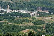
. Base camp is situated along the mighty Beas river, with tall and old Pine trees alongside the road.
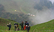
Two days are kept for orientation and acclimatization at base camp, which includes rappelling and rock climbing
Rock climbing
Rock climbing also lightly called 'The Gravity Game', is a sport in which participants climb up, down or across natural rock formations or artificial rock walls. The goal is to reach the summit of a formation or the endpoint of a pre-defined route without falling...
on one day and trekking up the nearby forests for a few kilometers up and down with a decent amount of weight in ones rucksack. After this, trekkers are ready to leave for their next destination.
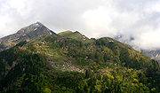
Segli
Kullu
Kullu, once known as Kul-anti-peetha - "the end of the habitable world", is the capital town of the Kullu District, in the state of Himachal Pradesh, India. It is located on the banks of the Beas River in the Kullu Valley about ten kilometres north of the airport at Bhuntar.Kullu is a broad open...
- Manali Highway by Bus). Camp is in an apple orchard and is surrounded by forests along the narrow trail.
Haura Thatch
Maylee Thatch
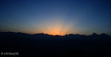
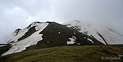
As one moves up, the trek becomes more and more difficult, though one is better equipped than the previous day through sheer experience. After 6 km of difficult and tiring trek, one wonders as to when he will reach the destination. However, this tiredness goes away on reaching the camp at Maylee Thatch (10,500 ft). A thatch is basically a vast ground with varied flora and fauna.Morning is studded with magnificent split-second changing views, starting with wonderful Morning Glows due to the effect of the first rays of Sun on the Mountain Peaks along with beautiful colorful patterns of the clouds. It changes so fast, that an opportunity missed is an opportunity lost.
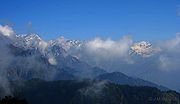
After a while, the valley below is completely under clouds, while everything is so bright and colorful above, as if being seen from an aeroplane. In no time every thing including our camp, is taken over by the clouds with a very poor visibility around us.
Doura Thatch
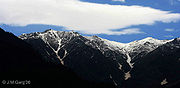
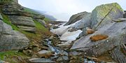
After trekking for about 10 km through the clouds and trekking a bit on the snow for the first time, trekkers reach their next camp at Doura Thatch (11,300 ft.). This day’s trek is basically a journey through the clouds. It is during this stretch that they have the first feeling of trekking on the snow.Saurkundi Pass
Longa Thatch
Lekhni
Finally after trekking another 10 km mainly down-hill, they reach their last camp site of Lekhni (8,100 ft.). It is situated alongside an apple orchard and one comes back across the civilization.One finally treks downhill from Lekhni to Aalloo ground along the Manali-Kullu
Kullu
Kullu, once known as Kul-anti-peetha - "the end of the habitable world", is the capital town of the Kullu District, in the state of Himachal Pradesh, India. It is located on the banks of the Beas River in the Kullu Valley about ten kilometres north of the airport at Bhuntar.Kullu is a broad open...
highway and from there by bus back to Babeli
Babeli
Babeli is a village in Tehsil Phagwara, Kapurthala district, in Punjab, India.-Demographics:According to the 2001 Census, Babeli has a population of 590 people. Neighbouring villages include Domeli., Bhabhiana, Rampur Sunra, Jagpalpur, Sikri, Dugga, Ucha, and Musapur.-Gurdwara Chounta...
. Here, the group breaks out after morning breakfast.
External links
- http://www.yhaindia.org/saurkundi-pass.htm on Saurkundi Pass Trek of Youth Hostels Association of India.
- http://www.yhaindia.org/Transaction/AdventurePrograms/ProgramDetails.aspx on National Himalayan Trekking Expedition of Youth Hostels Association of India.
- http://www.yhaindia.org/default.aspx on Youth Hostels Association of India.
- Butterflies, Landscapes etc. of Saurkundi Pass Trek
- Birds of Sar Pass Trek & Saurkundi Pass Trek
- Butterflies of Sar Pass Trek & Saurkundi Pass Trek
- Landscapes of Saurkundi Pass Trek