

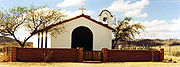
Sasabe, Arizona
Encyclopedia
Unincorporated area
In law, an unincorporated area is a region of land that is not a part of any municipality.To "incorporate" in this context means to form a municipal corporation, a city, town, or village with its own government. An unincorporated community is usually not subject to or taxed by a municipal government...
border community in the Altar Valley
Altar Valley
The Altar Valley is a 45-mile long north-south valley, trending slightly northeast from Sasabe, Arizona on the Mexico border to the Avra Valley, Arizona west of the Tucson Mountains...
of southern Pima County
Pima County, Arizona
-2010:Whereas according to the 2010 U.S. Census Bureau:*74.3% White*3.5% Black*3.3% Native American*2.6% Asian*0.2% Native Hawaiian or Pacific Islander*3.7% Two or more races*12.4% Other races*34.6% Hispanic or Latino -2000:...
, Arizona
Arizona
Arizona ; is a state located in the southwestern region of the United States. It is also part of the western United States and the mountain west. The capital and largest city is Phoenix...
, United States
United States
The United States of America is a federal constitutional republic comprising fifty states and a federal district...
. It hosts a little-used United States–Mexico
Mexico
The United Mexican States , commonly known as Mexico , is a federal constitutional republic in North America. It is bordered on the north by the United States; on the south and west by the Pacific Ocean; on the southeast by Guatemala, Belize, and the Caribbean Sea; and on the east by the Gulf of...
border crossing. Sasabe, Arizona is much smaller than its sister community, El Sásabe
Sáric
Sáric is a small town and the municipal area around it, located in the extreme north of the Mexican state of Sonora. Its northern boundary is the U.S. state of Arizona. The population of the municipality was 2,703 in 2010 living in an area of 1,676.23 square kilometers. The elevation is...
, Sonora
Sonora
Sonora officially Estado Libre y Soberano de Sonora is one of the 31 states which, with the Federal District, comprise the 32 Federal Entities of Mexico. It is divided into 72 municipalities; the capital city is Hermosillo....
, which is known for its burnt-adobe brickyard
Brickyard
A brickyard is a place or yard where the earthen building material called bricks are made, fired, and stored, or sometimes sold or otherwise distributed from.-See also:...
s.
Sasabe is best known for its historic Rancho de la Osa guest ranch, formerly the headquarters of a three million acre (12,000 km²) Spanish land grant
Land grant
A land grant is a gift of real estate – land or its privileges – made by a government or other authority as a reward for services to an individual, especially in return for military service...
. Some ranch buildings reportedly date to the late 17th century. The guest ranch opened in 1921. Guests have included Presidents Franklin Roosevelt and Lyndon Johnson.
Much of the area north and east of Sasabe is within the Buenos Aires National Wildlife Refuge
Buenos Aires National Wildlife Refuge
Buenos Aires National Wildlife Refuge provides of habitat for threatened and endangered plants and animals. The refuge was established in 1985.-Natural history:...
. In 2006, 3500 acres (14.2 km²) of the refuge that border Mexico east of Sasabe were closed to public entry due to problems with smugglers and unauthorized border crossings.
Sasabe has the ZIP Code
ZIP Code
ZIP codes are a system of postal codes used by the United States Postal Service since 1963. The term ZIP, an acronym for Zone Improvement Plan, is properly written in capital letters and was chosen to suggest that the mail travels more efficiently, and therefore more quickly, when senders use the...
of 85633; in 2000, the population of the 85633 ZCTA
ZIP Code Tabulation Area
ZIP Code Tabulation Areas are statistical entities developed by the United States Census Bureau for tabulating summary statistics from Census 2000. This new entity was developed to overcome the difficulties in precisely defining the land area covered by each ZIP code...
was 122.