
Santee, California
Encyclopedia
Santee is a suburban city in San Diego County
, California
with a population of 53,413 at the 2010 census. Although it is a part of the East County
region, Santee is located just 18 miles (29 km) from the Pacific Ocean. The city is connected to the coastline by State Route 52, a six-lane freeway that runs from Interstate 5 in La Jolla to State Route 67 in El Cajon. The city is bisected by the San Diego River, a linear greenbelt that includes parks, trails and more than 1100 acres (4.5 km²) of natural riparian habitat. The city's potential for growth and progress was touted in a San Diego Union-Tribune editorial titled "All Roads Lead to Santee".
Unlike most of the county's coastal cities, Santee still has sizable portions of vacant land suitable for development. It is a growing suburban community that in recent years has added upscale housing, a major corporate business park and expansive shopping centers, along with a destination recreational complex called Sportsplex USA Santee.
Outdoors: In addition to being a popular spot for mountain bikers, the city hosts a popular Southern California rock climbing venue called Santee Boulders
. Santee Lakes Regional Park and Campground offers 190 acre (0.7689034 km²) for fishing, camping, bird watching and picnicking.
Golf: A local landmark since 1958, the Carlton Oaks Golf Course and resort offers a premier golfing destination. The course was designed by the legendary Pete Dye
,who is in the World Golf Hall of Fame.
Music: A 10-week series of free concerts is organized each summer by the city's Community Services Department. The Santee Wine & Bluegrass Festival,http://www.ci.santee.ca.us/Index.aspx?page=74 a fund-raiser for local park and youth recreation programs, is held each fall at Town Center Community Park.
, currently of the Washington Nationals, graduated from Santee's West Hills High School and was the school's 2006 Scholar-Athlete of the Year.
, a ranching pioneer in the San Diego area.
has recently been extended eastward through this area from its current terminus at State Route 125
to State Route 67
on the city's east side. The city is bisected by four main thoroughfares: Mast Boulevard and Mission Gorge Road traverse east and west, while Magnolia Avenue and Cuyamaca Street cross north and south. Santee also is the eastern terminus of the San Diego Metropolitan Transit System
(MTS) Green Line trolley route, which connects East County to Old Town and downtown San Diego. MTS also provides bus service. Gillespie Field
, the oldest and largest of eight commercial aviation airports operated by San Diego County, is located on Santee's southern border with the city of El Cajon. The airport serves as a hub for local businesses.
As of 2011, the city had completed about half of a 4 miles (6.4 km)-long riverfront trail system that will eventually connect with trails in Lakeside and Mission Trails Regional Park.
Located on 15 acres (60,702.9 m²) in Santee is the Las Colinas Detention Facility, which serves as the primary point of intake for women prisoners in San Diego County. It began as a juvenile facility in 1967 and was converted to an adult women’s institution in 1979.
was 3,231.6 people per square mile (1,247.7/km²). The racial makeup of Santee was 44,083 (82.5%) White, 1,057 (2.0%) African American, 409 (0.8%) Native American, 2,044 (3.8%) Asian (1.8% Filipino, 0.4% Chinese, 0.5% Vietnamese, 0.3% Japanese, 0.2% Korean, 0.2% Indian, 0.5% Other), 253 (0.5%) Pacific Islander, 2,677 (5.0%) from other races
, and 2,890 (5.4%) from two or more races. Hispanic or Latino of any race were 8,699 persons (16.3%).
The Census reported that 52,447 people (98.2% of the population) lived in households, 77 (0.1%) lived in non-institutionalized group quarters, and 889 (1.7%) were institutionalized.
There were 19,306 households, out of which 7,156 (37.1%) had children under the age of 18 living in them, 10,304 (53.4%) were opposite-sex married couples
living together, 2,614 (13.5%) had a female householder with no husband present, 1,157 (6.0%) had a male householder with no wife present. There were 1,135 (5.9%) unmarried opposite-sex partnerships
, and 119 (0.6%) same-sex married couples or partnerships. 3,986 households (20.6%) were made up of individuals and 1,534 (7.9%) had someone living alone who was 65 years of age or older. The average household size was 2.72. There were 14,075 families
(72.9% of all households); the average family size was 3.13.
The population was spread out with 12,710 people (23.8%) under the age of 18, 5,068 people (9.5%) aged 18 to 24, 14,790 people (27.7%) aged 25 to 44, 15,105 people (28.3%) aged 45 to 64, and 5,740 people (10.7%) who were 65 years of age or older. The median age was 37.2 years. For every 100 females there were 93.6 males. For every 100 females age 18 and over, there were 90.2 males.
There were 20,048 housing units at an average density of 1,212.9 per square mile (468.3/km²), of which 13,576 (70.3%) were owner-occupied, and 5,730 (29.7%) were occupied by renters. The homeowner vacancy rate was 1.5%; the rental vacancy rate was 4.0%. 36,198 people (67.8% of the population) lived in owner-occupied housing units and 16,249 people (30.4%) lived in rental housing units.
of 2000, there were 52,975 people, 18,470 households, and 14,018 families residing in the city. The population density
was 3,298.7 inhabitants per square mile (1,273.6/km2). There were 18,833 housing units at an average density of 1,172.7 per square mile (452.8/km2). The racial makeup of the city was 86.70% White, 1.48% African American, 0.81% Native American, 2.55% Asian, 0.41% Pacific Islander, 4.03% from other races
, and 4.03% from two or more races. Hispanic or Latino of any race were 11.36% of the population.
There were 18,470 households out of which 40.9% had children under the age of 18 living with them, 57.7% were married couples
living together, 13.0% had a female householder with no husband present, and 24.1% were non-families. 18.2% of all households were made up of individuals and 6.9% had someone living alone who was 65 years of age or older. The average household size was 2.81 and the average family size was 3.19.
In the city, the population was spread out with 28.2% under the age of 18, 8.4% from 18 to 24, 32.9% from 25 to 44, 21.6% from 45 to 64, and 8.9% who were 65 years of age or older. The median age was 35 years. For every 100 females there were 93.2 males. For every 100 females age 18 and over, there were 89.1 males.
Estimated median household income in 2008: $71,806 (it was $53,624 in 2000)
Santee: $71,806
California: $61,021
Estimated per capita income in 2008: $28,330
Estimated median house or condo value in 2008: $393,609 (it was $172,800 in 2000)
Santee: $393,609
California: $467,000
Mean prices in 2008: All housing units: $358,473; Detached houses: $439,456; Townhouses or other attached units: $268,881; In 2-unit structures: $388,840; In 3-to-4-unit structures: $292,418; In 5-or-more-unit structures: $258,262; Mobile homes: $41,759; Occupied boats, RVs, vans, etc.: $95,000
Santee is located in the 36th Senate
District, represented by Republican
Joel Anderson
, and in the 77th Assembly
District, represented by Republican Brian Jones
, a former Santee Councilmember. Santee is located in California's 52nd congressional district
, which has a Cook PVI
of R +9 and is represented by Republican Duncan D. Hunter
.
 Santee is served by two school districts: Santee School District
and Grossmont Union High School District
. The two high schools in Santee are West Hills High School
and Santana High School
, they are both part of the Grossmont Union High School District. Elementary and junior high education is unique in Santee. Each campus serves kindergarten through eighth grade (k-8). The schools are divided into Elementary (k-6) and Junior High (7-8). Each using different parts of the campus, and having different start and end times. This is contrary to the traditional practice of many smaller elementary schools feeding students into consolidated middle schools.
.
San Diego County, California
San Diego County is a large county located in the southwestern corner of the US state of California. Hence, San Diego County is also located in the southwestern corner of the 48 contiguous United States. Its county seat and largest city is San Diego. Its population was about 2,813,835 in the 2000...
, California
California
California is a state located on the West Coast of the United States. It is by far the most populous U.S. state, and the third-largest by land area...
with a population of 53,413 at the 2010 census. Although it is a part of the East County
East County, San Diego
East County is a region of San Diego County, California. It is east of the city of San Diego.-Geography:East County does not have an official geographic definition. It commonly includes the four cities east of San Diego and South Bay—El Cajon, La Mesa, Santee, and Lemon Grove—as well as suburban...
region, Santee is located just 18 miles (29 km) from the Pacific Ocean. The city is connected to the coastline by State Route 52, a six-lane freeway that runs from Interstate 5 in La Jolla to State Route 67 in El Cajon. The city is bisected by the San Diego River, a linear greenbelt that includes parks, trails and more than 1100 acres (4.5 km²) of natural riparian habitat. The city's potential for growth and progress was touted in a San Diego Union-Tribune editorial titled "All Roads Lead to Santee".
Community profile
In 2010, the city was populated by 19,272 households, of which 64 percent had incomes greater than $45,000 annually. In 2009, the median household income was $78,872 per year, according to the San Diego Association of Governments. In 2010, Santee had one of the lowest crime rates among cities in San Diego County.Unlike most of the county's coastal cities, Santee still has sizable portions of vacant land suitable for development. It is a growing suburban community that in recent years has added upscale housing, a major corporate business park and expansive shopping centers, along with a destination recreational complex called Sportsplex USA Santee.
Recreational attractions
Sports: Sportsplex USA Santee,http://www.sportsplexusa.com/Santee/AboutSantee a 15 acres (60,702.9 m²) sports field complex, opened on June 1, 2010. Located within Town Center Community Park, it features three lighted softball fields, four batting cages, two lighted arena soccer fields, spectator seating, parking and a sports-themed restaurant offering food, beer and wine.Outdoors: In addition to being a popular spot for mountain bikers, the city hosts a popular Southern California rock climbing venue called Santee Boulders
Santee Boulders
Santee Boulders is a rock outcropping and recreational rock climbing area in the northern section of Santee, California.It is well-known for its thin faces and mantels. However, it also has challenging cracks and steep face climbs....
. Santee Lakes Regional Park and Campground offers 190 acre (0.7689034 km²) for fishing, camping, bird watching and picnicking.
Golf: A local landmark since 1958, the Carlton Oaks Golf Course and resort offers a premier golfing destination. The course was designed by the legendary Pete Dye
Pete Dye
Paul B. "Pete" Dye is a world-renowned golf course designer and a member of a famous family of course designers. He is married to fellow designer and former amateur champion Alice Dye.-Early life:Pete Dye was born in Urbana, Ohio...
,who is in the World Golf Hall of Fame.
Music: A 10-week series of free concerts is organized each summer by the city's Community Services Department. The Santee Wine & Bluegrass Festival,http://www.ci.santee.ca.us/Index.aspx?page=74 a fund-raiser for local park and youth recreation programs, is held each fall at Town Center Community Park.
Notable persons from Santee
Sharon Ryder Davis, wife of former California Gov. Gray Davis, was raised in the city and was crowned Miss Santee in 1968. Major League Baseball pitching pheom Stephen StrasburgStephen Strasburg
Stephen James Strasburg is a right-handed pitcher for the Washington Nationals, who selected him with the first pick in the 2009 Major League Baseball Draft...
, currently of the Washington Nationals, graduated from Santee's West Hills High School and was the school's 2006 Scholar-Athlete of the Year.
History
Original inhabitants were the Kumeyaay Indians, who established a village on the banks of the San Diego River called Sinyeweche. The city is named after Milton Santee, second husband of Jennie Blodgett, whose first husband was George A. CowlesGeorge A. Cowles
George A. Cowles was one of San Diego's early prominent ranching pioneers. George Cowles settled in the El Cajon valley in 1877, having first visited San Diego in 1873, then selecting this area over others he had considered in the relatively new state of California.-Early life:Born April 5, 1836...
, a ranching pioneer in the San Diego area.
Transportation
State Route 52California State Route 52
State Route 52 is a state highway in the U.S. state of California in San Diego County, that extends from La Jolla Parkway at Interstate 5 in La Jolla to Route 67 in Santee. Route 52 is a freeway for its entire length...
has recently been extended eastward through this area from its current terminus at State Route 125
California State Route 125
State Route 125 is a state highway in the U.S. state of California that currently runs from State Route 905 in Otay Mesa near the U.S.–Mexico border to State Route 52 in Santee....
to State Route 67
California State Route 67
State Route 67 runs from Interstate 8 in El Cajon to Lakeside as the San Vicente Freeway. It then becomes a smaller roadway through Poway and becomes Main Street in Ramona before ending into State Route 78....
on the city's east side. The city is bisected by four main thoroughfares: Mast Boulevard and Mission Gorge Road traverse east and west, while Magnolia Avenue and Cuyamaca Street cross north and south. Santee also is the eastern terminus of the San Diego Metropolitan Transit System
San Diego Metropolitan Transit System
The San Diego Metropolitan Transit System is the public transit service provider for Central, South, Northeast and Southeast San Diego County, in the United States. MTS operating subsidiaries include the San Diego Trolley, Incorporated , and San Diego Transit Corporation...
(MTS) Green Line trolley route, which connects East County to Old Town and downtown San Diego. MTS also provides bus service. Gillespie Field
Gillespie Field
Gillespie Field is a county-owned public-use airport located 10 miles northeast of the central business district of San Diego, in El Cajon, San Diego County, California, United States....
, the oldest and largest of eight commercial aviation airports operated by San Diego County, is located on Santee's southern border with the city of El Cajon. The airport serves as a hub for local businesses.
Public facilities
The 55 acres (222,577.3 m²) Town Center Community Park is located east of Cuyamaca Street along the San Diego River. The center of the park features a 15 acres (60,702.9 m²) sports field complex operated by Sportsplex USA Santee, and an aquatics center operated by the East County YMCA. The park's first two phases were completed in the fall of 2010. The $23.5 million facility was funded through a combination of redevelopment bonds, developer impact fees and grants.As of 2011, the city had completed about half of a 4 miles (6.4 km)-long riverfront trail system that will eventually connect with trails in Lakeside and Mission Trails Regional Park.
Located on 15 acres (60,702.9 m²) in Santee is the Las Colinas Detention Facility, which serves as the primary point of intake for women prisoners in San Diego County. It began as a juvenile facility in 1967 and was converted to an adult women’s institution in 1979.
Geography
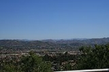
Santee, which averages 300 feet (91.4 m) above sea level, shares the northern part of a valley with the city of El Cajon. The city is bisected by the San Diego River, which flows east to west for approximately 4.2 miles (6.8 km) within the city limits. Hills form a natural barrier on its northern and western sides. Prominently overlooking the western side of Santee is Cowles Mountain. This natural landmark, which is the highest point in the city of San Diego, offers sweeping views of the county and is a popular hiking destination.Demographics
2010
The 2010 United States Census reported that Santee had a population of 53,413. The population densityPopulation density
Population density is a measurement of population per unit area or unit volume. It is frequently applied to living organisms, and particularly to humans...
was 3,231.6 people per square mile (1,247.7/km²). The racial makeup of Santee was 44,083 (82.5%) White, 1,057 (2.0%) African American, 409 (0.8%) Native American, 2,044 (3.8%) Asian (1.8% Filipino, 0.4% Chinese, 0.5% Vietnamese, 0.3% Japanese, 0.2% Korean, 0.2% Indian, 0.5% Other), 253 (0.5%) Pacific Islander, 2,677 (5.0%) from other races
Race (United States Census)
Race and ethnicity in the United States Census, as defined by the Federal Office of Management and Budget and the United States Census Bureau, are self-identification data items in which residents choose the race or races with which they most closely identify, and indicate whether or not they are...
, and 2,890 (5.4%) from two or more races. Hispanic or Latino of any race were 8,699 persons (16.3%).
The Census reported that 52,447 people (98.2% of the population) lived in households, 77 (0.1%) lived in non-institutionalized group quarters, and 889 (1.7%) were institutionalized.
There were 19,306 households, out of which 7,156 (37.1%) had children under the age of 18 living in them, 10,304 (53.4%) were opposite-sex married couples
Marriage
Marriage is a social union or legal contract between people that creates kinship. It is an institution in which interpersonal relationships, usually intimate and sexual, are acknowledged in a variety of ways, depending on the culture or subculture in which it is found...
living together, 2,614 (13.5%) had a female householder with no husband present, 1,157 (6.0%) had a male householder with no wife present. There were 1,135 (5.9%) unmarried opposite-sex partnerships
POSSLQ
POSSLQ is an abbreviation for "Persons of Opposite Sex Sharing Living Quarters," a term coined in the late 1970s by the United States Census Bureau as part of an effort to more accurately gauge the prevalence of cohabitation in American households....
, and 119 (0.6%) same-sex married couples or partnerships. 3,986 households (20.6%) were made up of individuals and 1,534 (7.9%) had someone living alone who was 65 years of age or older. The average household size was 2.72. There were 14,075 families
Family (U.S. Census)
A family or family household is defined by the United States Census Bureau for statistical purposes as "a householder and one or more other people related to the householder by birth, marriage, or adoption. They do not include same-sex married couples even if the marriage was performed in a state...
(72.9% of all households); the average family size was 3.13.
The population was spread out with 12,710 people (23.8%) under the age of 18, 5,068 people (9.5%) aged 18 to 24, 14,790 people (27.7%) aged 25 to 44, 15,105 people (28.3%) aged 45 to 64, and 5,740 people (10.7%) who were 65 years of age or older. The median age was 37.2 years. For every 100 females there were 93.6 males. For every 100 females age 18 and over, there were 90.2 males.
There were 20,048 housing units at an average density of 1,212.9 per square mile (468.3/km²), of which 13,576 (70.3%) were owner-occupied, and 5,730 (29.7%) were occupied by renters. The homeowner vacancy rate was 1.5%; the rental vacancy rate was 4.0%. 36,198 people (67.8% of the population) lived in owner-occupied housing units and 16,249 people (30.4%) lived in rental housing units.
2000
As of the censusCensus
A census is the procedure of systematically acquiring and recording information about the members of a given population. It is a regularly occurring and official count of a particular population. The term is used mostly in connection with national population and housing censuses; other common...
of 2000, there were 52,975 people, 18,470 households, and 14,018 families residing in the city. The population density
Population density
Population density is a measurement of population per unit area or unit volume. It is frequently applied to living organisms, and particularly to humans...
was 3,298.7 inhabitants per square mile (1,273.6/km2). There were 18,833 housing units at an average density of 1,172.7 per square mile (452.8/km2). The racial makeup of the city was 86.70% White, 1.48% African American, 0.81% Native American, 2.55% Asian, 0.41% Pacific Islander, 4.03% from other races
Race (United States Census)
Race and ethnicity in the United States Census, as defined by the Federal Office of Management and Budget and the United States Census Bureau, are self-identification data items in which residents choose the race or races with which they most closely identify, and indicate whether or not they are...
, and 4.03% from two or more races. Hispanic or Latino of any race were 11.36% of the population.
There were 18,470 households out of which 40.9% had children under the age of 18 living with them, 57.7% were married couples
Marriage
Marriage is a social union or legal contract between people that creates kinship. It is an institution in which interpersonal relationships, usually intimate and sexual, are acknowledged in a variety of ways, depending on the culture or subculture in which it is found...
living together, 13.0% had a female householder with no husband present, and 24.1% were non-families. 18.2% of all households were made up of individuals and 6.9% had someone living alone who was 65 years of age or older. The average household size was 2.81 and the average family size was 3.19.
In the city, the population was spread out with 28.2% under the age of 18, 8.4% from 18 to 24, 32.9% from 25 to 44, 21.6% from 45 to 64, and 8.9% who were 65 years of age or older. The median age was 35 years. For every 100 females there were 93.2 males. For every 100 females age 18 and over, there were 89.1 males.
Estimated median household income in 2008: $71,806 (it was $53,624 in 2000)
Santee: $71,806
California: $61,021
Estimated per capita income in 2008: $28,330
Estimated median house or condo value in 2008: $393,609 (it was $172,800 in 2000)
Santee: $393,609
California: $467,000
Mean prices in 2008: All housing units: $358,473; Detached houses: $439,456; Townhouses or other attached units: $268,881; In 2-unit structures: $388,840; In 3-to-4-unit structures: $292,418; In 5-or-more-unit structures: $258,262; Mobile homes: $41,759; Occupied boats, RVs, vans, etc.: $95,000
Politics
In 2011, the Santee City Council was composed of Mayor Randy Voepel and council members Jack Dale, John W. Minto, John Ryan and Rob McNelis. In the state legislatureCalifornia State Legislature
The California State Legislature is the state legislature of the U.S. state of California. It is a bicameral body consisting of the lower house, the California State Assembly, with 80 members, and the upper house, the California State Senate, with 40 members...
Santee is located in the 36th Senate
California State Senate
The California State Senate is the upper house of the California State Legislature. There are 40 state senators. The state legislature meets in the California State Capitol in Sacramento. The Lieutenant Governor is the ex officio President of the Senate and may break a tied vote...
District, represented by Republican
Republican Party (United States)
The Republican Party is one of the two major contemporary political parties in the United States, along with the Democratic Party. Founded by anti-slavery expansion activists in 1854, it is often called the GOP . The party's platform generally reflects American conservatism in the U.S...
Joel Anderson
Joel Anderson
Joel Anderson is a California politician and Republican member of the California State Senate in the 36th Senate District. Before his election to the State Senate he was a member of the California Assembly representing the 77th Assembly District, and he also served on the Padre Dam Municipal Water...
, and in the 77th Assembly
California State Assembly
The California State Assembly is the lower house of the California State Legislature. There are 80 members in the Assembly, representing an approximately equal number of constituents, with each district having a population of at least 420,000...
District, represented by Republican Brian Jones
Brian Jones
Lewis Brian Hopkins Jones , known as Brian Jones, was an English musician and a founding member of the Rolling Stones....
, a former Santee Councilmember. Santee is located in California's 52nd congressional district
California's 52nd congressional district
California's 52nd congressional district is a congressional district in the U.S. state of California based in San Diego County. The district consists of many of San Diego's suburbs, including Lakeside, Poway, Ramona, La Mesa, and Spring Valley....
, which has a Cook PVI
Cook Partisan Voting Index
The Cook Partisan Voting Index , sometimes referred to as simply the Partisan Voting Index , is a measurement of how strongly an American congressional district or state leans toward one political party compared to the nation as a whole...
of R +9 and is represented by Republican Duncan D. Hunter
Duncan D. Hunter
Duncan Duane Hunter is the U.S. Representative for , serving since 2009. He is a member of the Republican Party. He is the son of his predecessor Duncan Hunter...
.
Schools
Santee School District
Santee School District is the district that governs all public elementary schools in Santee, California...
and Grossmont Union High School District
Grossmont Union High School District
The Grossmont Union High School District is a public school district located in eastern San Diego County, California, and serves high school, adult school, and Regional Occupational Program students in the cities of El Cajon, La Mesa, Lemon Grove, and Santee; and the unincorporated communities of...
. The two high schools in Santee are West Hills High School
West Hills High School
West Hills High School is a public, comprehensive high school located in Santee, California, and serves students in grades nine through twelve...
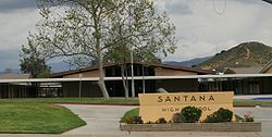
and Santana High School
Santana High School
Santana High School, located in Santee, California, is part of the Grossmont Union High School District. The school serves 1,750 students in grades 9-12, as well as 84 faculty members.-History:...
, they are both part of the Grossmont Union High School District. Elementary and junior high education is unique in Santee. Each campus serves kindergarten through eighth grade (k-8). The schools are divided into Elementary (k-6) and Junior High (7-8). Each using different parts of the campus, and having different start and end times. This is contrary to the traditional practice of many smaller elementary schools feeding students into consolidated middle schools.
Elementary and junior high campuses
All elementary and junior high campuses are part of the Santee School DistrictSantee School District
Santee School District is the district that governs all public elementary schools in Santee, California...
.
- Cajon Park School
- Carlton Hills School
- Carlton Oaks School
- Chet F. Harrit School
- Hill Creek School
- Pepper Drive School
- Prospect Avenue School
- Rio Seco School
- Sycamore Canyon School
High schools
There are two high schools in Santee. Both are part of the Grossmont High School District.- Santana High SchoolSantana High SchoolSantana High School, located in Santee, California, is part of the Grossmont Union High School District. The school serves 1,750 students in grades 9-12, as well as 84 faculty members.-History:...
- West Hills High SchoolWest Hills High SchoolWest Hills High School is a public, comprehensive high school located in Santee, California, and serves students in grades nine through twelve...