
Santa Venetia, California
Encyclopedia
Santa Venetia is a census-designated place
(CDP) in Marin County
, California
, United States
. Santa Venetia is located 1.5 miles (2.4 km) north of downtown San Rafael
, at an elevation of 56 feet (17 m). The population was 4,292 at the 2010 census.
According to the United States Census Bureau
, the CDP has a total area of 3.7 square miles (9.6 km²), of which, 3.7 square miles (9.6 km²) of it is land and 0.51% is water.
Santa Venetia was envisioned in the early 1900s as a little Venice so canals were built and houses and structures built along them. It was a vacation spot for the wealthy for a brief period of time in the 1920s. The plan of building a little Venice was abandoned. In the 1960s, houses were built along North San Pedro Road.
The main road of this unincorporated neighborhood is North San Pedro Road, which passes by the Frank Lloyd Wright
-designed Marin County Civic Center
. The road goes through China Camp State Park
, along the bay through Peacock Gap and ends in San Rafael
. Santa Venetia has an open space preserve for its marsh as it borders San Pablo Bay
, the northern part of the San Francisco Bay
estuary.
was 1,166.3 people per square mile (450.3/km²). The racial makeup of Santa Venetia was 3,335 (77.7%) White, 88 (2.1%) African American, 27 (0.6%) Native American, 306 (7.1%) Asian, 16 (0.4%) Pacific Islander, 350 (8.2%) from other races
, and 170 (4.0%) from two or more races. Hispanic or Latino of any race were 815 persons (19.0%).
The Census reported that 4,080 people (95.1% of the population) lived in households, 65 (1.5%) lived in non-institutionalized group quarters, and 147 (3.4%) were institutionalized.
There were 1,655 households, out of which 480 (29.0%) had children under the age of 18 living in them, 769 (46.5%) were opposite-sex married couples
living together, 180 (10.9%) had a female householder with no husband present, 81 (4.9%) had a male householder with no wife present. There were 87 (5.3%) unmarried opposite-sex partnerships
, and 21 (1.3%) same-sex married couples or partnerships. 455 households (27.5%) were made up of individuals and 228 (13.8%) had someone living alone who was 65 years of age or older. The average household size was 2.47. There were 1,030 families
(62.2% of all households); the average family size was 2.97.
The population was spread out with 802 people (18.7%) under the age of 18, 220 people (5.1%) aged 18 to 24, 961 people (22.4%) aged 25 to 44, 1,435 people (33.4%) aged 45 to 64, and 874 people (20.4%) who were 65 years of age or older. The median age was 47.7 years. For every 100 females there were 90.2 males. For every 100 females age 18 and over, there were 87.1 males.
There were 1,706 housing units at an average density of 463.6 per square mile (179.0/km²), of which 1,188 (71.8%) were owner-occupied, and 467 (28.2%) were occupied by renters. The homeowner vacancy rate was 1.1%; the rental vacancy rate was 2.1%. 2,925 people (68.2% of the population) lived in owner-occupied housing units and 1,155 people (26.9%) lived in rental housing units.
of 2000, there were 4,298 people, 1,646 households, and 1,048 families residing in the CDP. The population density
was 1,143.0 people per square mile (441.3/km²). There were 1,667 housing units at an average density of 443.3 per square mile (171.2/km²). The racial makeup of the CDP in 2010 was 68.5% non-Hispanic White, 2.0% non-Hispanic African American, 0.2% Native American, 7.0% Asian, 0.3% Pacific Islander, 0.3% from other races
, and 2.6% from two or more races. Hispanic or Latino of any race were 19.0% of the population.
There were 1,646 households out of which 25.5% had children under the age of 18 living with them, 49.0% were married couples
living together, 10.6% had a female householder with no husband present, and 36.3% were non-families. 26.2% of all households were made up of individuals and 12.7% had someone living alone who was 65 years of age or older. The average household size was 2.47 and the average family size was 2.91.
In the CDP the population was spread out with 18.1% under the age of 18, 5.2% from 18 to 24, 27.3% from 25 to 44, 29.1% from 45 to 64, and 20.3% who were 65 years of age or older. The median age was 45 years. For every 100 females there were 93.0 males. For every 100 females age 18 and over, there were 87.5 males.
The median income for a household in the CDP was $75,600, and the median income for a family was $77,202. Males had a median income of $48,938 versus $42,500 for females. The per capita income
for the CDP was $34,732. About 4.3% of families and 7.3% of the population were below the poverty line, including 10.3% of those under age 18 and 6.1% of those age 65 or over.
, Italy (hence the name "Santa Venetia" - there is no actual Christian saint
named Venice or Venetia), complete with canals and gondolas. The economic decline following the First World War put an end to this development.
Back in the day Marin-ites used to refer to Santa Venetia as 'Lower Skabo'. No one is sure where this started (however it is rumoured to be a reference to Lower Slobbovia from Lil' Abner, due to Santa Venetia's geographical separation from San Rafael proper.) but it was widely know by this name throughout the 50-60s and still in the 2000s you hear highschoolers using this name.
It was only after the Second World War that significant development took place in Santa Venetia, with suburban developments such as Gallinas Village being built on the land originally filled in 1914.
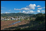
Today Santa Venetia is a quiet neighborhood with a rural feel. Residents treasure its proximity to China Camp State Park, and many homes along the canal have water access.
The SVNA holds regular community meetings, hosts social events and neighborhood work days, and publishes an exemplary bimonthly newsletter. http://thesvna.org
Census-designated place
A census-designated place is a concentration of population identified by the United States Census Bureau for statistical purposes. CDPs are delineated for each decennial census as the statistical counterparts of incorporated places such as cities, towns and villages...
(CDP) in Marin County
Marin County, California
Marin County is a county located in the North San Francisco Bay Area of the U.S. state of California, across the Golden Gate Bridge from San Francisco. As of 2010, the population was 252,409. The county seat is San Rafael and the largest employer is the county government. Marin County is well...
, California
California
California is a state located on the West Coast of the United States. It is by far the most populous U.S. state, and the third-largest by land area...
, United States
United States
The United States of America is a federal constitutional republic comprising fifty states and a federal district...
. Santa Venetia is located 1.5 miles (2.4 km) north of downtown San Rafael
San Rafael, California
San Rafael is a city and the county seat of Marin County, California, United States. The city is located in the North Bay region of the San Francisco Bay Area...
, at an elevation of 56 feet (17 m). The population was 4,292 at the 2010 census.
Geography
Santa Venetia is located at 37°59′55"N 122°31′31"W.According to the United States Census Bureau
United States Census Bureau
The United States Census Bureau is the government agency that is responsible for the United States Census. It also gathers other national demographic and economic data...
, the CDP has a total area of 3.7 square miles (9.6 km²), of which, 3.7 square miles (9.6 km²) of it is land and 0.51% is water.
Santa Venetia was envisioned in the early 1900s as a little Venice so canals were built and houses and structures built along them. It was a vacation spot for the wealthy for a brief period of time in the 1920s. The plan of building a little Venice was abandoned. In the 1960s, houses were built along North San Pedro Road.
The main road of this unincorporated neighborhood is North San Pedro Road, which passes by the Frank Lloyd Wright
Frank Lloyd Wright
Frank Lloyd Wright was an American architect, interior designer, writer and educator, who designed more than 1,000 structures and completed 500 works. Wright believed in designing structures which were in harmony with humanity and its environment, a philosophy he called organic architecture...
-designed Marin County Civic Center
Marin County Civic Center
Marin County Civic Center, the last commission by Frank Lloyd Wright, is located in San Rafael, California. Groundbreaking for the Civic Center Administration Building took place in 1960, after Wright's death and under the watch of Wright's protégé, Aaron Green, and was completed in 1962. The...
. The road goes through China Camp State Park
China Camp State Park
China Camp State Park is a state park of California, USA, surrounding a historic Chinese American shrimp-fishing village and a salt marsh. The park is located in San Rafael, California, on the shore of San Pablo Bay. It is known for its hiking and mountain biking trails, scenic views, and open...
, along the bay through Peacock Gap and ends in San Rafael
San Rafael, California
San Rafael is a city and the county seat of Marin County, California, United States. The city is located in the North Bay region of the San Francisco Bay Area...
. Santa Venetia has an open space preserve for its marsh as it borders San Pablo Bay
San Pablo Bay
San Pablo Bay is a tidal estuary that forms the northern extension of San Francisco Bay in northern California in the United States. Most of the Bay is shallow; however, there is a deep water channel approximately in mid bay, which allows access to Sacramento, Stockton, Benicia, Martinez, and...
, the northern part of the San Francisco Bay
San Francisco Bay
San Francisco Bay is a shallow, productive estuary through which water draining from approximately forty percent of California, flowing in the Sacramento and San Joaquin rivers from the Sierra Nevada mountains, enters the Pacific Ocean...
estuary.
2010
The 2010 United States Census reported that Santa Venetia had a population of 4,292. The population densityPopulation density
Population density is a measurement of population per unit area or unit volume. It is frequently applied to living organisms, and particularly to humans...
was 1,166.3 people per square mile (450.3/km²). The racial makeup of Santa Venetia was 3,335 (77.7%) White, 88 (2.1%) African American, 27 (0.6%) Native American, 306 (7.1%) Asian, 16 (0.4%) Pacific Islander, 350 (8.2%) from other races
Race (United States Census)
Race and ethnicity in the United States Census, as defined by the Federal Office of Management and Budget and the United States Census Bureau, are self-identification data items in which residents choose the race or races with which they most closely identify, and indicate whether or not they are...
, and 170 (4.0%) from two or more races. Hispanic or Latino of any race were 815 persons (19.0%).
The Census reported that 4,080 people (95.1% of the population) lived in households, 65 (1.5%) lived in non-institutionalized group quarters, and 147 (3.4%) were institutionalized.
There were 1,655 households, out of which 480 (29.0%) had children under the age of 18 living in them, 769 (46.5%) were opposite-sex married couples
Marriage
Marriage is a social union or legal contract between people that creates kinship. It is an institution in which interpersonal relationships, usually intimate and sexual, are acknowledged in a variety of ways, depending on the culture or subculture in which it is found...
living together, 180 (10.9%) had a female householder with no husband present, 81 (4.9%) had a male householder with no wife present. There were 87 (5.3%) unmarried opposite-sex partnerships
POSSLQ
POSSLQ is an abbreviation for "Persons of Opposite Sex Sharing Living Quarters," a term coined in the late 1970s by the United States Census Bureau as part of an effort to more accurately gauge the prevalence of cohabitation in American households....
, and 21 (1.3%) same-sex married couples or partnerships. 455 households (27.5%) were made up of individuals and 228 (13.8%) had someone living alone who was 65 years of age or older. The average household size was 2.47. There were 1,030 families
Family (U.S. Census)
A family or family household is defined by the United States Census Bureau for statistical purposes as "a householder and one or more other people related to the householder by birth, marriage, or adoption. They do not include same-sex married couples even if the marriage was performed in a state...
(62.2% of all households); the average family size was 2.97.
The population was spread out with 802 people (18.7%) under the age of 18, 220 people (5.1%) aged 18 to 24, 961 people (22.4%) aged 25 to 44, 1,435 people (33.4%) aged 45 to 64, and 874 people (20.4%) who were 65 years of age or older. The median age was 47.7 years. For every 100 females there were 90.2 males. For every 100 females age 18 and over, there were 87.1 males.
There were 1,706 housing units at an average density of 463.6 per square mile (179.0/km²), of which 1,188 (71.8%) were owner-occupied, and 467 (28.2%) were occupied by renters. The homeowner vacancy rate was 1.1%; the rental vacancy rate was 2.1%. 2,925 people (68.2% of the population) lived in owner-occupied housing units and 1,155 people (26.9%) lived in rental housing units.
2000
As of the censusCensus
A census is the procedure of systematically acquiring and recording information about the members of a given population. It is a regularly occurring and official count of a particular population. The term is used mostly in connection with national population and housing censuses; other common...
of 2000, there were 4,298 people, 1,646 households, and 1,048 families residing in the CDP. The population density
Population density
Population density is a measurement of population per unit area or unit volume. It is frequently applied to living organisms, and particularly to humans...
was 1,143.0 people per square mile (441.3/km²). There were 1,667 housing units at an average density of 443.3 per square mile (171.2/km²). The racial makeup of the CDP in 2010 was 68.5% non-Hispanic White, 2.0% non-Hispanic African American, 0.2% Native American, 7.0% Asian, 0.3% Pacific Islander, 0.3% from other races
Race (United States Census)
Race and ethnicity in the United States Census, as defined by the Federal Office of Management and Budget and the United States Census Bureau, are self-identification data items in which residents choose the race or races with which they most closely identify, and indicate whether or not they are...
, and 2.6% from two or more races. Hispanic or Latino of any race were 19.0% of the population.
There were 1,646 households out of which 25.5% had children under the age of 18 living with them, 49.0% were married couples
Marriage
Marriage is a social union or legal contract between people that creates kinship. It is an institution in which interpersonal relationships, usually intimate and sexual, are acknowledged in a variety of ways, depending on the culture or subculture in which it is found...
living together, 10.6% had a female householder with no husband present, and 36.3% were non-families. 26.2% of all households were made up of individuals and 12.7% had someone living alone who was 65 years of age or older. The average household size was 2.47 and the average family size was 2.91.
In the CDP the population was spread out with 18.1% under the age of 18, 5.2% from 18 to 24, 27.3% from 25 to 44, 29.1% from 45 to 64, and 20.3% who were 65 years of age or older. The median age was 45 years. For every 100 females there were 93.0 males. For every 100 females age 18 and over, there were 87.5 males.
The median income for a household in the CDP was $75,600, and the median income for a family was $77,202. Males had a median income of $48,938 versus $42,500 for females. The per capita income
Per capita income
Per capita income or income per person is a measure of mean income within an economic aggregate, such as a country or city. It is calculated by taking a measure of all sources of income in the aggregate and dividing it by the total population...
for the CDP was $34,732. About 4.3% of families and 7.3% of the population were below the poverty line, including 10.3% of those under age 18 and 6.1% of those age 65 or over.
History
Santa Venetia is built on marshland that was filled in 1914. At that time, real estate developer Mabry McMahan envisioned a bayside luxury development modeled after VeniceVenice
Venice is a city in northern Italy which is renowned for the beauty of its setting, its architecture and its artworks. It is the capital of the Veneto region...
, Italy (hence the name "Santa Venetia" - there is no actual Christian saint
Saint
A saint is a holy person. In various religions, saints are people who are believed to have exceptional holiness.In Christian usage, "saint" refers to any believer who is "in Christ", and in whom Christ dwells, whether in heaven or in earth...
named Venice or Venetia), complete with canals and gondolas. The economic decline following the First World War put an end to this development.
Back in the day Marin-ites used to refer to Santa Venetia as 'Lower Skabo'. No one is sure where this started (however it is rumoured to be a reference to Lower Slobbovia from Lil' Abner, due to Santa Venetia's geographical separation from San Rafael proper.) but it was widely know by this name throughout the 50-60s and still in the 2000s you hear highschoolers using this name.
It was only after the Second World War that significant development took place in Santa Venetia, with suburban developments such as Gallinas Village being built on the land originally filled in 1914.
Today Santa Venetia is a quiet neighborhood with a rural feel. Residents treasure its proximity to China Camp State Park, and many homes along the canal have water access.
Notable residents
- Science fiction author Philip K. DickPhilip K. DickPhilip Kindred Dick was an American novelist, short story writer and essayist whose published work is almost entirely in the science fiction genre. Dick explored sociological, political and metaphysical themes in novels dominated by monopolistic corporations, authoritarian governments and altered...
lived in Santa Venetia from 1967–1972. His experiences during this time formed much of the basis for his novel A Scanner DarklyA Scanner DarklyA Scanner Darkly is a BSFA Award winning 1977 science fiction novel by American writer Philip K. Dick. The semi-autobiographical story is set in a dystopian Orange County, California, in the then-future of June 1994...
.
The Santa Venetia Neighborhood Association
The SVNA is an active force in keeping Santa Venetia a vibrant community. Its mission: To preserve and promote the quality of life in the Santa Venetia community. This is achieved through encouraging healthy social interaction; facilitating the flow of information; and protecting the natural beauty and economic well-being of the community.The SVNA holds regular community meetings, hosts social events and neighborhood work days, and publishes an exemplary bimonthly newsletter. http://thesvna.org