

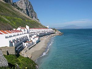
Sandy Bay, Gibraltar
Encyclopedia
Headlands and bays
Headlands and bays are two related features of the coastal environment.- Geology and geography :Headlands and bays are often found on the same coastline. A bay is surrounded by land on three sides, whereas a headland is surrounded by water on three sides. Headlands are characterized by high,...
on the eastern Mediterranean coast
Mediterranean Sea
The Mediterranean Sea is a sea connected to the Atlantic Ocean surrounded by the Mediterranean region and almost completely enclosed by land: on the north by Anatolia and Europe, on the south by North Africa, and on the east by the Levant...
of Gibraltar
Gibraltar
Gibraltar is a British overseas territory located on the southern end of the Iberian Peninsula at the entrance of the Mediterranean. A peninsula with an area of , it has a northern border with Andalusia, Spain. The Rock of Gibraltar is the major landmark of the region...
, on the opposite side of The Rock
Rock of Gibraltar
The Rock of Gibraltar is a monolithic limestone promontory located in Gibraltar, off the southwestern tip of Europe on the Iberian Peninsula. It is high...
from the main city. It is situated to the south of Catalan Bay
Catalan Bay
Catalan Bay is a small bay and fishing village in Gibraltar, on the eastern side of The Rock away from the main city.-Etymology:The true origin of the name of Catalan Bay is unknown, but a couple of theories exist...
and is accessible via Sir Herbert Miles
Herbert Miles
Lieutenant General Sir Herbert Scott Gould Miles GCB GCMG GBE CVO was Quartermaster-General to the Forces.-Military career:Miles was commissioned into the 101st Regiment of Foot in 1869....
Road.
Water Catchments
Directly above Sandy Bay and the Sir Herbert Miles coast road were Gibraltar's large Water Catchments which are no longer in use. The slope on which they sat is an ancient consolidated sand dune which dominates the Eastside of the Rock of GibraltarRock of Gibraltar
The Rock of Gibraltar is a monolithic limestone promontory located in Gibraltar, off the southwestern tip of Europe on the Iberian Peninsula. It is high...
. The dune's naturally smooth surface allowed for the construction of a water catchment area made up of a corrugated steel
Corrugated galvanised iron
Corrugated galvanised iron is a building material composed of sheets of hot-dip galvanised mild steel, cold-rolled to produce a linear corrugated pattern in them...
sheets and a layer of concrete
Concrete
Concrete is a composite construction material, composed of cement and other cementitious materials such as fly ash and slag cement, aggregate , water and chemical admixtures.The word concrete comes from the Latin word...
. Rain
Rain
Rain is liquid precipitation, as opposed to non-liquid kinds of precipitation such as snow, hail and sleet. Rain requires the presence of a thick layer of the atmosphere to have temperatures above the melting point of water near and above the Earth's surface...
water flowed down the slope into an open channel which fed into the reservoir system inside The Rock.
In 1898, work began on four 5,000,000 gallon water reservoirs which were cut into the western side of The Rock. They were officially opened by Governor
Governor of Gibraltar
The Governor and Commander-in-Chief of Gibraltar is the representative of the British monarch in the British overseas territory of Gibraltar. The Governor is appointed by the British Monarch on the advice of the British Government...
George Stuart White in 1901. These reservoirs were fed by relatively small water catchment areas on the western side of The Rock.
The Water Catchments above Sandy Bay were built in stages between 1903 and 1961, and were designed to cater for Gibraltar's ever increasing demand. The original plan was to cover an area of 10 acres (40,468.6 m²). Between 1911 and 1914 a fifth reservoir was excavated inside the Rock and the catchment area increased to 24 acres (97,124.6 m²). By 1961 the total catchment area had increased to its maximum of 34 acres (137,593.2 m²).
Today
In 2001, the Gibraltar Ornithological and Natural History Society began to manage the phased work of dismantling this catchment construction. By 2006 the slope was entirely restored to its natural state and is now completely covered in vegetation native to this unique habitat of Gibraltar.It is possible to continue south along Sir Herbert Miles road and through Dudley Ward Tunnel
Dudley Ward Tunnel
The Dudley Ward Tunnel is a road tunnel through the south-eastern part of the Rock of Gibraltar. It is named after Sir Alfred Dudley Ward, Governor of Gibraltar from 8 June 1962 to 5 August 1965...
all the way to Europa Point
Europa Point
Europa Point, also called Great Europa Point, is the southernmost point of Gibraltar. At the end of Rock of Gibraltar, the area is flat and occupied by such features as a playing field and a few buildings...
at the southern tip of Gibraltar. Following a rockfall
Rockfall
Rockfall or rock-fall refers to quantities of rock falling freely from a cliff face. A rockfall is a fragment of rock detached by sliding, toppling, or falling, that falls along a vertical or sub-vertical cliff, proceeds down slope by bouncing and flying along ballistic trajectories or by rolling...
on 18 February 2002, which killed a man, the Government concluded that the risk of further such incidents was too great, and the tunnel was closed indefinitely. However, in 2007 its reopening was suggested by the Government to ease traffic flow in the area of the new Rosia residential developments. The tunnel re-opened in November 2010, on completion of extensive engineering works.
Sandy Bay is home to one of the few residential areas on the Eastside of The Rock, known as Both Worlds.
See also
- Catalan BayCatalan BayCatalan Bay is a small bay and fishing village in Gibraltar, on the eastern side of The Rock away from the main city.-Etymology:The true origin of the name of Catalan Bay is unknown, but a couple of theories exist...
- Eastern Beach, GibraltarEastern Beach, GibraltarEastern Beach is the largest beach in Gibraltar, stretching for several hundred metres along the east side of the isthmus joining The Rock to Spain. The sandy beach extends from the north of Catalan Bay to the runway of Gibraltar Airport....