

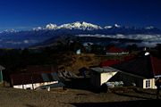
Sandakfu
Encyclopedia


West Bengal
West Bengal is a state in the eastern region of India and is the nation's fourth-most populous. It is also the seventh-most populous sub-national entity in the world, with over 91 million inhabitants. A major agricultural producer, West Bengal is the sixth-largest contributor to India's GDP...
, India
India
India , officially the Republic of India , is a country in South Asia. It is the seventh-largest country by geographical area, the second-most populous country with over 1.2 billion people, and the most populous democracy in the world...
. It is situated at the edge of the Singalila National Park
Singalila National Park
Singalila National Park is a national park of India located on the Singalila Ridge at an altitude of more than 7000 feet above sea level, in the Darjeeling district of West Bengal. It is well known for the trekking route to Sandakphu that runs through it....
in Darjeeling district
Darjeeling district
Darjeeling District is the northernmost district of the state of West Bengal in eastern India in the foothills of the Himalayas. The district is famous for its beautiful hill stations and Darjeeling tea. Darjeeling is the district headquarters...
on the West Bengal
West Bengal
West Bengal is a state in the eastern region of India and is the nation's fourth-most populous. It is also the seventh-most populous sub-national entity in the world, with over 91 million inhabitants. A major agricultural producer, West Bengal is the sixth-largest contributor to India's GDP...
-Sikkim
Sikkim
Sikkim is a landlocked Indian state nestled in the Himalayan mountains...
border, and is the highest point of the Singalila Ridge
Singalila Ridge
The Singalila Ridge is a North - South running mountain ridge in Northwestern West Bengal, India.The district of Ilam falls on the western part of this ridge and the northern ridge ends up in Sikkim Part of the Himalayas, it separates other mountain ranges of West Bengal from other Himalayan...
. Sandakphu has a small village on the peak with a number of hostels. The peaks of Kanchendzonga
Kangchenjunga
Kangchenjunga is the third highest mountain of the world with an elevation of and located along the India-Nepal border in the Himalayas.Kangchenjunga is also the name of the section of the Himalayas and means "The Five Treasures of Snows", as it contains five peaks, four of them over...
and Everest
Mount Everest
Mount Everest is the world's highest mountain, with a peak at above sea level. It is located in the Mahalangur section of the Himalayas. The international boundary runs across the precise summit point...
can be seen from its summit.
From Sandakphu the best view of the mountain Kanchendzonga is possible, which is known as the sleeping Buddha or the sleeping Shiva.
How to reach
Sandakphu can be reached by trekking. The trekking starts from Manebhanjan via Tonglu, Kala PokhriKala Pokhri
Kala Pokhri is a small Himalayan village inside the Singalila National Park in the Darjeeling subdivision, Darjeeling district in the state of West Bengal, India. It lies on the trekking route from Mane Bhanjang to Sandakphu , and is roughly halfway between the steep final stretch of the trek from...
, Meghma
Meghma
Meghma is a small hamlet inside the Singalila National Park in the Darjeeling subdivision, Darjeeling district in the state of West Bengal in India near the India - Nepal border, and lies on the Sandakphu trek.-Tourism:...
to Sandakphu.
Trekking
The trek along the Singalila Ridge to Sandakphu and Phalut is one of the most popular ones in the Eastern Himalayas due to the grand vistas of the Kanchenjunga range and the Everest range which can be seen from the ridge, and also for the seasonal wildflower blooms and birding. Treks begin at Manebhanjan which is 51 km (1.5 hours by road) from Darjeeling.The trekking routes inside the Singalila National Park have four legs or stages.
- Manebhanjan to Meghma (2600 m): This is a 4 hour trek through the lower forest.
- Meghma to Gairibans (2621 m): There are two alternative trekking routes. Both go via Tonglu (3070 m) and Tumling (2900 m). The boundary of the national park passes though Tumling where a checkpost is located. From Tumling, a shorter trail cuts through Nepal and Jaubari (2750 m).
- Gairibans to Sandakphu (3636 m): This is a steep 4 hour climb. Roughly half-way up the climb is the village of Kala PokhriKala PokhriKala Pokhri is a small Himalayan village inside the Singalila National Park in the Darjeeling subdivision, Darjeeling district in the state of West Bengal, India. It lies on the trekking route from Mane Bhanjang to Sandakphu , and is roughly halfway between the steep final stretch of the trek from...
(3186 m). - Sandakphu to Phalut (3600 m): This is the most pristine stretch of the trek, offering great views of Kanchenjunga and Mt. Everest. It is a one-day trek via Sabarkum (3536 m) covering 21 km. But the main problem of this Sandakphu-Phalut route is that there is no water source in between, so the trekkers have to carry enough water to reach Phalut.
The descent from Sandakphu can be accomplished in several ways:
- Retracing the way back to Manebhanjan.
- A steep descent to the village of Sirikhola on the banks of the River Sirikhola, via Gurdum (2300 m), and from there to RimbickRimbickRimbick is a village near the India-Nepal border in the Darjeeling district of West Bengal state, India. It is 100 km away from Darjeeling town....
. - There is now a 4WD motorable road to Sandakphu, so one can hire a cab down to Manebhanjan and Darjeeling via Tumling and Tonglu if needed. The drive on the gravel road, however, is very arduous.