

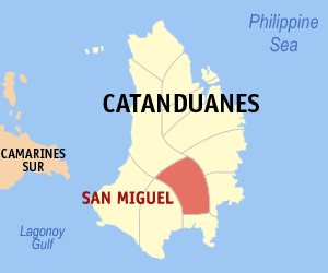
San Miguel, Catanduanes
Encyclopedia
Philippines
The Philippines , officially known as the Republic of the Philippines , is a country in Southeast Asia in the western Pacific Ocean. To its north across the Luzon Strait lies Taiwan. West across the South China Sea sits Vietnam...
. According to the 2007 census, it has a population of 12,966 people in 2,387 households.
History
San Miguel, which is once, a part of the Municipality of Bato, first inhabited by the early mountaineers and the part of the Malayan race that were pushed to the open valley with the coming of the Spanish Colonizers.There are myths and fables about how the town got its name. According to a pioneer, San Miguel was once a sitio known as “Aguas” named after fish species bigger than the “Balanak”. In the 1930’s during the celebration of the feast in honor of Santa Cruz the former Patron Saint; Aguas was changed to San Miguel in grateful recognition and commendation to the invaluable services of Don Miguel Triumfante and Juez de Cnado of Bato who were present then during the celebration.
There was also an event handed down to the present generation that once upon a time the chapel caretaker in the person of Marcelo Tapanan, in one early morning heard a long and loud ringing of bells. He hurried to the chapel and was surprised to see the image of Saint Michael the Archangel in the altar. The story passed on every ear of the residents and finally made a common move of changing the name of the place from Aguas to San Miguel.
Formerly, a barrio of San Miguel, Bato become a full pledge municipality through then President Elpidio Quirino’s Executive Order No. 803 dated August 23, 1952 comprising previously twelve (12) barangays.
Since its emancipation in 1952, San Miguel Municipality is now forty-four years old. The reign of government was handed down through political choice; the first town mayor was Torribio Taopa who was chosen through a plebiscite in 1952 until the first local elections in 1953 where he won.
Living memory testifies that San Miguel was once upon a time a forlorn and poor orphan of its mother town of Bato. Its life was filled with lonely chapters, too, with its pain and headache, longing and privations. Now, it presents a brighter picture. Past and present administrators with the aid of support of the National, Regional and Provincial Government had transformed the town from the limbo of backwardness into the light and aura of dynamic activities and achievements.
The Municipality of San Miguel is located at the Mid-south part of the province of Catanduanes. It is bounded on the north by the municipality of Caramoran, on the east by the municipality of Baras and Gigmoto, on the west by the municipality of Virac and on the south by the municipality of Bato.
Presently, the municipality of San Miguel has 24 barangays. It has a total land area of 18,372.5 hectares. San Miguel geographical location has the following orientation in terms of coordinate: 124o21’-124.9o21’ longitude and 13o37’-13o47’ latitude
The present mayor is Edna Bernal who is on her second-term after winning over former Mayor and former SP Francisco Camano Jr.
Barangays
San Miguel is politically subdivided into 24 barangayBarangay
A barangay is the smallest administrative division in the Philippines and is the native Filipino term for a village, district or ward...
s.
| Barangay | Pop. (2007) |
|---|---|
| Balatohan | |
| Salvacion (Patagan) | |
| Boton | |
| Buhi | |
| Dayawa | |
| Atsan (District I) | |
| Poblacion District II | |
| Poblacion District III | |
| J.M. Alberto | |
| Katipunan | |
| Kilikilihan | |
| Mabato | |
| Barangay | Pop. (2007) |
|---|---|
| Obo | |
| Pacogon | |
| Pagsangahan | |
| Pangilaw | |
| Paraiso | |
| Santa Elena (Patagan) | |
| Progreso | |
| San Juan (Aroyao) | |
| San Marcos | |
| Siay | |
| Solong | |
| Tobrehon | |