
San Andreas Lake
Encyclopedia
San Andreas Lake is a reservoir
adjacent to the San Francisco Peninsula
cities of Millbrae
and San Bruno
in San Mateo County, California
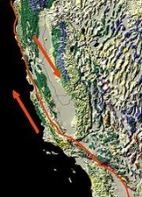
. It is situated directly on the San Andreas Fault
, which is named after the lake.
on November 4, 1769, the Portolà expedition
descended what Portolà
called the Cañada de San Francisco, now San Andreas Creek
, to camp the next day at a '"Laguna Grande" which today is covered by the Upper Crystal Springs Reservoir. The campsite is marked by California Historical Marker No. 94 "Portola Expedition Camp", located at Crystal Springs Dam, on Skyline Boulevard, 0.1 mi south of Crystal Springs Road. They camped here a second time on November 12, on their return trip. Padre Palóu
, on an expedition from Monterey to explore the western side of San Francisco Bay led by Captain Rivera
, renamed Portola's Cañada de San Francisco to Cañada de San Andrés on November 30, 1774, it being the feast day of St. Andrew. Captain Juan Bautista de Anza
, after forging the first overland route from Monterey, California
to San Francisco Bay, explored the peninsula and selected the sites for Mission San Francisco de Asís
(Mission Dolores) and the Presidio of San Francisco
. De Anza returned to Monterey via the Cañada de San Andrés and camped on the banks of San Mateo Creek on March 29, 1776. In de Anza's diary on March 29, 1776, he wrote: "Night having fallen, at a quarter past six I went down to the arroyo of San Andreas and to another, that of San Matheo, where it descends to empty into the estuary..."
, the lake was expanded by the construction of a 100 foot high earth dam in 1868. The dam survived the 1906 earthquake despite the fact that the fault runs directly under the dam.
In 1895, Professor Andrew Lawson
of the University of California, Berkeley
, conferred the name of the lake on the earthquake fault he discovered in its vicinity.
, crosses the rift valley
on the San Andreas Dam. This 6 mile (10 km) trail eventually reaches the eastern shores of the Lower Crystal Springs reservoir and the Crystal Springs Dam
.
Reservoir
A reservoir , artificial lake or dam is used to store water.Reservoirs may be created in river valleys by the construction of a dam or may be built by excavation in the ground or by conventional construction techniques such as brickwork or cast concrete.The term reservoir may also be used to...
adjacent to the San Francisco Peninsula
San Francisco Peninsula
The San Francisco Peninsula is a peninsula in the San Francisco Bay Area that separates the San Francisco Bay from the Pacific Ocean. On its northern tip is the City and County of San Francisco. Its southern base is in Santa Clara County, including the cities of Palo Alto, Los Altos, and Mountain...
cities of Millbrae
Millbrae, California
Millbrae is a city in San Mateo County, California, United States, just west of San Francisco Bay, with San Bruno on the north and Burlingame on the south. The population was 21,532 at the 2010 census.-History:...
and San Bruno
San Bruno, California
San Bruno is a city in San Mateo County, California, United States. The population was 41,114 at the 2010 census.The city is adjacent to San Francisco International Airport and Golden Gate National Cemetery.-Geography:San Bruno is located at...
in San Mateo County, California
San Mateo County, California
San Mateo County is a county located in the San Francisco Bay Area of the U.S. state of California. It covers most of the San Francisco Peninsula just south of San Francisco, and north of Santa Clara County. San Francisco International Airport is located at the northern end of the county, and...
. It is situated directly on the San Andreas Fault
San Andreas Fault
The San Andreas Fault is a continental strike-slip fault that runs a length of roughly through California in the United States. The fault's motion is right-lateral strike-slip...
, which is named after the lake.
History
After discovering San Francisco Bay from Sweeney RidgeSweeney Ridge
Sweeney Ridge, a national park in Pacifica, California, is part of the Golden Gate National Recreation Area. Historically, the ridge was the location of the San Francisco Bay Discovery Site, as part of the Portolá Expedition on November 4, 1769.-Description:...
on November 4, 1769, the Portolà expedition
Portola expedition
250px|right|Point of San Francisco Bay DiscoveryThe Portolá Expedition was led by Gaspar de Portolá from July 14, 1769 to January 24, 1770. It was the first recorded Spanish land entry and exploration of present day California, United States...
descended what Portolà
Gaspar de Portolà
Gaspar de Portolà i Rovira was a soldier, governor of Baja and Alta California , explorer and founder of San Diego and Monterey. He was born in Os de Balaguer, province of Lleida, in Catalonia, Spain, of Catalan nobility. Don Gaspar served as a soldier in the Spanish army in Italy and Portugal...
called the Cañada de San Francisco, now San Andreas Creek
San Andreas Creek
San Andrés Creek , now called San Andreas Creek, is a perennial stream that flows miles southeasterly along the San Andreas Fault from Sweeney Ridge in San Mateo County, California, providing the inflow to and outflow from San Andreas Reservoir, and then entering Lower Crystal Springs Reservoir,...
, to camp the next day at a '"Laguna Grande" which today is covered by the Upper Crystal Springs Reservoir. The campsite is marked by California Historical Marker No. 94 "Portola Expedition Camp", located at Crystal Springs Dam, on Skyline Boulevard, 0.1 mi south of Crystal Springs Road. They camped here a second time on November 12, on their return trip. Padre Palóu
Francisco Palóu
Francesc Palou was a Franciscan missionary, administrator, and historian on the Baja California peninsula and in Alta California. Father Palou's made significant contributions to the Alta California and Baja California mission systems...
, on an expedition from Monterey to explore the western side of San Francisco Bay led by Captain Rivera
Fernando Rivera y Moncada
Fernando Javier Rivera y Moncada was a soldier from New Spain who served in the Baja California peninsula and upper Las Californias, participating in several early overland explorations. Fernando Rivera y Moncada served as a Spanish Miilitary Governor from 1774-1777. -Biography:Rivera was born...
, renamed Portola's Cañada de San Francisco to Cañada de San Andrés on November 30, 1774, it being the feast day of St. Andrew. Captain Juan Bautista de Anza
Juan Bautista de Anza
Juan Bautista de Anza Bezerra Nieto was a Novo-Spanish explorer and Governor of New Mexico for the Spanish Empire.-Early life:...
, after forging the first overland route from Monterey, California
Monterey, California
The City of Monterey in Monterey County is located on Monterey Bay along the Pacific coast in Central California. Monterey lies at an elevation of 26 feet above sea level. As of the 2010 census, the city population was 27,810. Monterey is of historical importance because it was the capital of...
to San Francisco Bay, explored the peninsula and selected the sites for Mission San Francisco de Asís
Mission San Francisco de Asís
Mission San Francisco de Asís, or Mission Dolores, is the oldest surviving structure in San Francisco and the sixth religious settlement established as part of the California chain of missions...
(Mission Dolores) and the Presidio of San Francisco
Presidio of San Francisco
The Presidio of San Francisco is a park on the northern tip of the San Francisco Peninsula in San Francisco, California, within the Golden Gate National Recreation Area...
. De Anza returned to Monterey via the Cañada de San Andrés and camped on the banks of San Mateo Creek on March 29, 1776. In de Anza's diary on March 29, 1776, he wrote: "Night having fallen, at a quarter past six I went down to the arroyo of San Andreas and to another, that of San Matheo, where it descends to empty into the estuary..."
Description
Originally a small natural sag pondSag pond
A sag pond is a body of water, which forms as water collects in the lowest parts of the depression that forms between two strands of an active strike-slip fault. The relative motion of the two fault strands results in a stretching of the land between them, causing the land between them to...
, the lake was expanded by the construction of a 100 foot high earth dam in 1868. The dam survived the 1906 earthquake despite the fact that the fault runs directly under the dam.
In 1895, Professor Andrew Lawson
Andrew Lawson
Andrew Cowper Lawson July 25,1861- June 16,1952 was a professor of geology at the University of California, Berkeley. He was the editor and co-author of the 1908 report on the 1906 San Francisco Earthquake which became known as the "Lawson Report"...
of the University of California, Berkeley
University of California, Berkeley
The University of California, Berkeley , is a teaching and research university established in 1868 and located in Berkeley, California, USA...
, conferred the name of the lake on the earthquake fault he discovered in its vicinity.
Public access
Since the lake is a public water source, it is closed to the public. However, hikers and bicyclists may travel along the eastern shores of the lake on a paved trail that runs just west of Skyline Boulevard from San Bruno Avenue to Millbrae Avenue. A connecting trail, called the Sawyer Camp TrailSawyer Camp Trail
Sawyer Camp Trail is a popular six mile trail located in the San Andreas Fault rift valley in San Mateo County, California near Hillsborough and the San Mateo Highlands. Approximately 300,000 people use the trail every year. It provides excellent views of San Francisco Peninsula's Crystal...
, crosses the rift valley
Rift valley
A rift valley is a linear-shaped lowland between highlands or mountain ranges created by the action of a geologic rift or fault. This action is manifest as crustal extension, a spreading apart of the surface which is subsequently further deepened by the forces of erosion...
on the San Andreas Dam. This 6 mile (10 km) trail eventually reaches the eastern shores of the Lower Crystal Springs reservoir and the Crystal Springs Dam
Crystal Springs Dam
Crystal Springs Dam is a gravity dam constructed across the San Mateo Creek, impounding water to form the Lower Crystal Springs Reservoir in San Mateo County, California....
.