

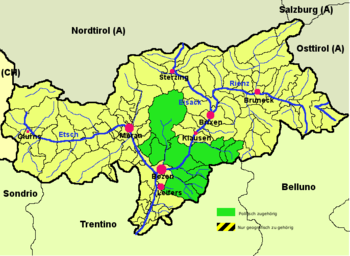
Salten-Schlern
Encyclopedia
South Tyrol
South Tyrol , also known by its Italian name Alto Adige, is an autonomous province in northern Italy. It is one of the two autonomous provinces that make up the autonomous region of Trentino-Alto Adige/Südtirol. The province has an area of and a total population of more than 500,000 inhabitants...
, Italy
Italy
Italy , officially the Italian Republic languages]] under the European Charter for Regional or Minority Languages. In each of these, Italy's official name is as follows:;;;;;;;;), is a unitary parliamentary republic in South-Central Europe. To the north it borders France, Switzerland, Austria and...
. It comprises the lower part of the valley of the Eisack
Eisack
The Eisack is a river in Northern Italy, the second largest river in South Tyrol. Its source is near the Brenner Pass, at an altitude of about 1990 m above sea level. The river draws water from an area of about 4,200 km². After about 96 km, it joins the Adige river south of Bolzano. At first the...
River, from Waidbruck to Bolzano. It is named after the Salten plaeau and the mountain Schlern
Schlern
The Schlern is a mountain of the Dolomites in South Tyrol, Italy.The peak at the north west end of the mountain was first ascended in 1888 by Johann Santner...
. The seat of the district is in Bolzano, itself not part of the district.
According to the 2001 census, 77.15% of the population of the district speak German, 18.82% Ladin
Ladin
Ladin is a language consisting of a group of dialects spoken in the Dolomite Mountains in Northern Italy in the border regions of the provinces Trentino, South Tyrol and Belluno...
and 4.03% Italian as mother language.
The following municipalities are part of the Salten-Schlern district:
- DeutschnofenDeutschnofenDeutschnofen is a comune in the province of South Tyrol in the Italian region of Trentino-Alto Adige/Südtirol, located about 70 km northeast of the city of Trento and about 30 km southeast of the city of Bolzano, on the border with Austria.-Geography:As of 30 November 2010, it had a...
- JenesienJenesienJenesien is a comune in the province of South Tyrol in the Italian region Trentino-Alto Adige/Südtirol, located about 50 km northeast of the city of Trento and about 4 km northwest of the city of Bolzano .-Geography:...
- KarneidKarneidKarneid is a comune in the province of South Tyrol in the Italian region Trentino-Alto Adige/Südtirol, located about 50 km northeast of the city of Trento and about 4 km east of the city of Bolzano .-Geography:...
- KastelruthKastelruthKastelruth is a comune in South Tyrol in the Italian region Trentino-Alto Adige/Südtirol, located about 70 km northeast of the city of Trento and about 20 km northeast of the city of Bolzano ....
- MöltenMöltenMölten is a comune in South Tyrol in the Italian region Trentino-Alto Adige/Südtirol, located about 60 km north of Trento and about 12 km northwest of Bolzano .-Geography:...
- RittenRittenRitten is a comune in South Tyrol in the Italian region Trentino-Alto Adige/Südtirol.-Territory:The 111 km² community is named after the high plateau , the Ritten or the Renon, on which most of the villages are located...
- Santa Cristina Gherdëina
- SarntalSarntalSarntal is a valley and a comune in South Tyrol in the Italian region Trentino-Alto Adige/Südtirol, located about 70 km northeast of the city of Trento and about 15 km north of the city of Bolzano....
- SëlvaSëlvaSëlva is a comune in the Val Gardena in South Tyrol, northern Italy, located about 70 km northeast of the city of Trento and about 30 km east of the city of Bolzano.-Geography:...
- Tiers
- UrtijëiUrtijëiUrtijëi is a town of 4,637 inhabitants in South Tyrol, in the Italian region of Trentino-Alto Adige/Südtirol. It occupies the Val Gardena within the Dolomites, a mountain chain that is part of the Alps...
- Völs am Schlern
- Welschnofen