

Salt Fork Arkansas River
Encyclopedia
Tributary
A tributary or affluent is a stream or river that flows into a main stem river or a lake. A tributary does not flow directly into a sea or ocean...
of the Arkansas River
Arkansas River
The Arkansas River is a major tributary of the Mississippi River. The Arkansas generally flows to the east and southeast as it traverses the U.S. states of Colorado, Kansas, Oklahoma, and Arkansas. The river's initial basin starts in the Western United States in Colorado, specifically the Arkansas...
in southern Kansas
Kansas
Kansas is a US state located in the Midwestern United States. It is named after the Kansas River which flows through it, which in turn was named after the Kansa Native American tribe, which inhabited the area. The tribe's name is often said to mean "people of the wind" or "people of the south...
and northern Oklahoma
Oklahoma
Oklahoma is a state located in the South Central region of the United States of America. With an estimated 3,751,351 residents as of the 2010 census and a land area of 68,667 square miles , Oklahoma is the 28th most populous and 20th-largest state...
in the United States
United States
The United States of America is a federal constitutional republic comprising fifty states and a federal district...
. Via the Arkansas River, it is part of the watershed
Drainage basin
A drainage basin is an extent or an area of land where surface water from rain and melting snow or ice converges to a single point, usually the exit of the basin, where the waters join another waterbody, such as a river, lake, reservoir, estuary, wetland, sea, or ocean...
of the Mississippi River
Mississippi River
The Mississippi River is the largest river system in North America. Flowing entirely in the United States, this river rises in western Minnesota and meanders slowly southwards for to the Mississippi River Delta at the Gulf of Mexico. With its many tributaries, the Mississippi's watershed drains...
.
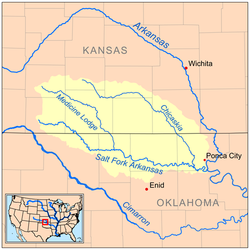
Course
The Salt Fork rises in Comanche County, KansasComanche County, Kansas
Comanche County is a county located in Southwest Kansas, in the Central United States. As of the 2010 census, the county population was 1,891...
, and flows initially southeastwardly through Barber County, Kansas
Barber County, Kansas
Barber County is a county located in South Central Kansas, in the Central United States. As of the 2010 census, the county population was 4,861. Its county seat and most populous city is Medicine Lodge...
, and Woods County, Oklahoma
Woods County, Oklahoma
Woods County is a county located in the U.S. state of Oklahoma. As of 2000, the population was 9,089. Its county seat is Alva. The county is named after Samuel Newitt Wood, a renowned Kansas populist. -Geography:According to the U.S...
, to the town of Alva
Alva, Oklahoma
Alva is a city in Woods County, Oklahoma, along the Salt Fork Arkansas River. The population was 4,945 at the 2010 census. It is the county seat of Woods County....
, where it turns eastwardly for the remainder of its course through Alfalfa
Alfalfa County, Oklahoma
Alfalfa County is a county located in the U.S. state of Oklahoma. As of 2000, the population is 6,105. Its county seat is Cherokee. Alfalfa County was formed in 1907 from Woods County. The county is named after William H...
, Grant
Grant County, Oklahoma
Grant County is a county located in the U.S. state of Oklahoma. As of 2010 census, the population was 4,527. Its county seat is Medford.-History:...
, Kay
Kay County, Oklahoma
Kay County is a county located in the U.S. state of Oklahoma. As of 2000, the population was 48,080. Its county seat is Newkirk. The largest city in Kay County is Ponca City.-19th century:...
and Noble
Noble County, Oklahoma
Noble County is a county located in the U.S. state of Oklahoma. As of 2010, the population was 11,561. Its county seat is Perry.-21st century:In 2010, the Keystone-Cushing Pipeline was constructed north to south through Noble County....
counties in Oklahoma, past the towns of Pond Creek
Pond Creek, Oklahoma
Pond Creek is a city in Grant County, Oklahoma, along the Salt Fork Arkansas River. As of the 2010 census, the city population was 856.-History:...
, Lamont
Lamont, Oklahoma
Lamont is a town in Grant County, Oklahoma, along the Salt Fork Arkansas River. The population was 465 at the 2000 census.-Geography:Lamont is located at ....
and Tonkawa
Tonkawa, Oklahoma
Tonkawa is a city in Kay County, Oklahoma, United States, along the Salt Fork Arkansas River. The population was 3,299 at the 2000 census.-History:...
. It flows into the Arkansas River in southern Kay County, 7 miles (11 km) south of Ponca City
Ponca City, Oklahoma
Ponca City is a small city in Kay and Osage counties in the U.S. state of Oklahoma, which was named after the Ponca Tribe. Located in north central Oklahoma, it lies approximately south of the Kansas border, and approximately east of Interstate 35. 25,919 people called Ponca City home at the...
.
In Alfalfa County, a dam
Dam
A dam is a barrier that impounds water or underground streams. Dams generally serve the primary purpose of retaining water, while other structures such as floodgates or levees are used to manage or prevent water flow into specific land regions. Hydropower and pumped-storage hydroelectricity are...
on the river maintains Great Salt Plains Lake
Great Salt Plains Lake
Great Salt Plains Lake is a reservoir located within the Salt Plains National Wildlife Refuge in Alfalfa County, Oklahoma in the United States named because of the salt flats in the area and for the Salt Fork Arkansas River, which is dammed to form the lake....
, which is lined with salt flats and is the site of Great Salt Plains National Wildlife Refuge and a state park
State park
State parks are parks or other protected areas managed at the federated state level within those nations which use "state" as a political subdivision. State parks are typically established by a state to preserve a location on account of its natural beauty, historic interest, or recreational...
.
The Salt Fork's largest tributaries are the Medicine Lodge River
Medicine Lodge River
The Medicine Lodge River is a tributary of the Salt Fork of the Arkansas River in southern Kansas and northern Oklahoma in the United States. Via the Salt Fork and Arkansas rivers, it is part of the watershed of the Mississippi River....
, which joins it in Alfalfa County and the Chikaskia River
Chikaskia River
The Chikaskia River is a tributary of the Salt Fork of the Arkansas River in southern Kansas and northern Oklahoma in the United States...
, which joins it in Kay County.
Variant names
According to the Geographic Names Information SystemGeographic Names Information System
The Geographic Names Information System is a database that contains name and locative information about more than two million physical and cultural features located throughout the United States of America and its territories. It is a type of gazetteer...
, the Salt Fork Arkansas River has also been known as:
|
|
Sources
- Columbia Gazetteer of North America entry
- DeLormeDeLormeDeLorme is a major vendor of business-to-business and consumer mapping and GPS products and technologies. It is based in Yarmouth, Maine, United States....
(2003). Kansas Atlas & Gazetteer. Yarmouth, Maine: DeLorme. ISBN 0-89933-342-7. - DeLormeDeLormeDeLorme is a major vendor of business-to-business and consumer mapping and GPS products and technologies. It is based in Yarmouth, Maine, United States....
(2003). Oklahoma Atlas & Gazetteer. Yarmouth, Maine: DeLorme. ISBN 0-89933-283-8.