
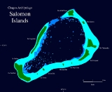
Salomon Islands
Encyclopedia
Atoll
An atoll is a coral island that encircles a lagoon partially or completely.- Usage :The word atoll comes from the Dhivehi word atholhu OED...
of the Chagos Archipelago
Chagos Archipelago
The Chagos Archipelago , is a group of seven atolls comprising more than 60 individual tropical islands in the Indian Ocean; situated some due south of the Maldives archipelago. This chain of islands are the southernmost archipelago of the Chagos-Laccadive Ridge a long submarine mountain range...
, British Indian Ocean Territory
British Indian Ocean Territory
The British Indian Ocean Territory or Chagos Islands is an overseas territory of the United Kingdom situated in the Indian Ocean, halfway between Africa and Indonesia...
.
Description
It is located in the Northeast of the Chagos ArchipelagoChagos Archipelago
The Chagos Archipelago , is a group of seven atolls comprising more than 60 individual tropical islands in the Indian Ocean; situated some due south of the Maldives archipelago. This chain of islands are the southernmost archipelago of the Chagos-Laccadive Ridge a long submarine mountain range...
, between Blenheim Reef
Blenheim Reef
Blenheim Reef is a partly submerged atoll structure in the Chagos Archipelago, Indian Ocean]]. It includes the coral reef of Baxio Predassa in its southeastern rim, plus another completely submerged part. It is located in the northeastern part of the Chagos Archipelago...
and Peros Banhos
Peros Banhos
Peros Banhos, Pedro dos Banhos or Baixo de Pero dos Banhos in old maps, is a formerly inhabited atoll in the Chagos Archipelago of the British Indian Ocean Territory....
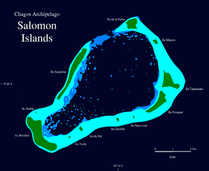
. The main islands in the group are Île Boddam, with the former main settlement, and a land area of 1.08 km², and Île Anglaise (0.82 km²), both on the western rim of the reef. There were smaller settlements of Chagossians in Fouquet (0.45 km²) and Takamaka (0.48 km) Islands. Île de la Passe is 0.28 km² in area, and Île Mapou 0.04 km². The remaining islets are much smaller.
The total land area is about 3.5 km².
There is a passage into the lagoon
Lagoon
A lagoon is a body of shallow sea water or brackish water separated from the sea by some form of barrier. The EU's habitat directive defines lagoons as "expanses of shallow coastal salt water, of varying salinity or water volume, wholly or partially separated from the sea by sand banks or shingle,...
, named Baie de Salomon, on the Northern side, between Île Anglaise and Île de la Passe. The Salomon Islands are one of the favorite anchoring spots for itinerant yachtsmen passing through the Chagos, even though there are no proper moorings for yachts and a permit of the BIOT authorities is needed. Now uninhabited, the islands are overrun by low jungle between the coconut trees and it is hard to find the traces of the former settlements.
History
This atoll was settled in the last half of the 18th century by coconut plantation workers from MauritiusMauritius
Mauritius , officially the Republic of Mauritius is an island nation off the southeast coast of the African continent in the southwest Indian Ocean, about east of Madagascar...
(then known as Île de France). Little is known about the condition of the workers who were mostly of African
African diaspora
The African diaspora was the movement of Africans and their descendants to places throughout the world—predominantly to the Americas also to Europe, the Middle East and other places around the globe...
origin. Most probably they lived in conditions close to slavery
Slavery
Slavery is a system under which people are treated as property to be bought and sold, and are forced to work. Slaves can be held against their will from the time of their capture, purchase or birth, and deprived of the right to leave, to refuse to work, or to demand compensation...
. The company exploiting the plantation was called the Chagos Agalega Company.
The Salomon Islands were surveyed in 1837 by Commander Robert Moresby
Robert Moresby
Robert Moresby was a distinguished captain of the British Royal Navy. He was also an excellent hydrographer, maritime surveyor and draughtsman....
of the Indian Navy on the HMS Benares. Moresby's survey produced the first detailed map of this atoll. The atoll was surveyed again in 1905 by Commander B.T. Sommerville on the HMS Sealark, who drew a more accurate map.
Some of the Salomon Islands were inhabited by the Chagossians, but at the time that the British Government decided to empty the Chagos of local inhabitants only Île Boddam was inhabited.
The inhabitants of the Salomon Islands, numbering about 400, were forcefully evicted by the British and resettled in Mauritius
Mauritius
Mauritius , officially the Republic of Mauritius is an island nation off the southeast coast of the African continent in the southwest Indian Ocean, about east of Madagascar...
.
Île Boddam had a jetty, shops, offices, a school, a church and a villa where the plantation manager lived. All these buildings are hidden by thick jungle now. There are wells in Boddam and Takamaka islands. It is possible to collect water by yachtsmen in order to replenish their supplies.
Islets
The individual islets of the atoll are, starting in the North, clockwise:- Île de la Passe
- Île Mapou
- Île Takamaka
- Île Fouquet
- Île Sepulture
- Île Jacobin
- Île du Sel
- Île Poule
- Île Boddam
- Île Diable
- Île Anglaise