

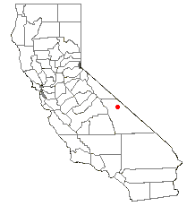
Saline Valley, California
Encyclopedia
Mojave Desert
The Mojave Desert occupies a significant portion of southeastern California and smaller parts of central California, southern Nevada, southwestern Utah and northwestern Arizona, in the United States...
of California
California
California is a state located on the West Coast of the United States. It is by far the most populous U.S. state, and the third-largest by land area...
. Most of it became a part of Death Valley National Park
Death Valley National Park
Death Valley National Park is a national park in the U.S. states of California and Nevada located east of the Sierra Nevada in the arid Great Basin of the United States. The park protects the northwest corner of the Mojave Desert and contains a diverse desert environment of salt-flats, sand dunes,...
when the park expanded in 1994. This area had previously been administered by the BLM. It is located northwest of Death Valley
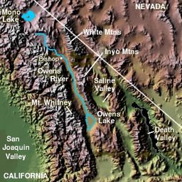
Death Valley
Death Valley is a desert valley located in Eastern California. Situated within the Mojave Desert, it features the lowest, driest, and hottest locations in North America. Badwater, a basin located in Death Valley, is the specific location of the lowest elevation in North America at 282 feet below...
proper, south of Eureka Valley
Eureka Valley, Inyo County
Eureka Valley is located in Inyo County, in eastern California in the southwestern United States. It is approximately 28 miles long and up to 10 miles wide, with elevations varying from 2870 feet up to 8456 feet...
, and east of the Owens Valley
Owens Valley
Owens Valley is the arid valley of the Owens River in eastern California in the United States, to the east of the Sierra Nevada and west of the White Mountains and Inyo Mountains on the west edge of the Great Basin section...
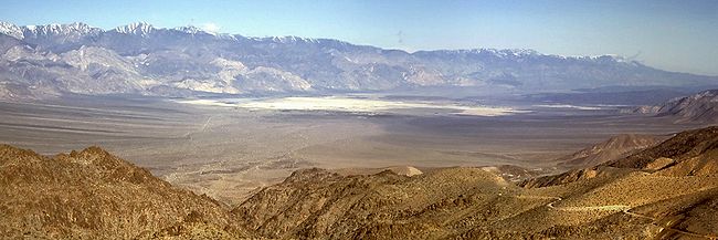
. The valley's lowest elevations are about 1000 feet (304.8 m) and it lies in the rain shadow of the 14000 feet (4,267.2 m) Sierra Nevada Range, plus the 11000 feet (3,352.8 m) Inyo Mountains
Inyo Mountains
The Inyo Mountains are a short mountain range east of the Sierra Nevada mountains in eastern California in the United States. The range separates the Owens Valley to the west with Saline Valley to the east, extending for approximately 70 mi SSE from the southern end of the White Mountains,...
bordering the valley on the west.
Natural features
Dry lake
Dry lakes are ephemeral lakebeds, or a remnant of an endorheic lake. Such flats consist of fine-grained sediments infused with alkali salts. Dry lakes are also referred to as alkali flats, sabkhas, playas or mud flats...
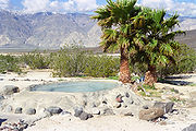
occupies the center of the valley. The west end of the lake supports a salt marsh
Salt marsh
A salt marsh is an environment in the upper coastal intertidal zone between land and salt water or brackish water, it is dominated by dense stands of halophytic plants such as herbs, grasses, or low shrubs. These plants are terrestrial in origin and are essential to the stability of the salt marsh...
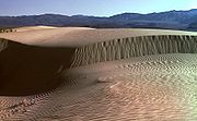
, which contains a variety of plant and animal life. The marsh is fed by a perennial stream from Hunter Canyon. North of the lake is a large area of low sand dunes.
There are a number of hot springs
Hot Springs
Hot Springs may refer to:* Hot Springs, Arkansas** Hot Springs National Park, Arkansas*Hot Springs, California**Hot Springs, Lassen County, California**Hot Springs, Modoc County, California**Hot Springs, Placer County, California...
in the northeast corner of the valley. The water temperature at the source of these springs averages at 107 °F (42 °C).
Saline Valley is a closed or endorheic basin. If filled with water it would be over 4000 feet (1200 m) deep, form a lake with a surface area of roughly 500 square miles (1,300 km²), and hold approximately 500000000 acre.ft of water.
Saline Valley Road
Saline Valley Road is a sporadically maintained dirt road running north-south through the length of the valley, and is the most commonly used access route. From SR 168 in the north to SR 190 in the south, it is 95 miles (153 km) long, and ranges in elevation from 1094 to 7593 feet (333 to 2314 m). It goes through two mountain passes: the Inyo Mountains in the north, and the Nelson RangeNelson Range
The Nelson Range is a subrange of the Selkirk Mountains in the West Kootenay region of British Columbia, Canada. It is located south of the west arm of Kootenay Lake between the Salmo and Kootenay Rivers and also to the west of the south arm of Kootenay Lake...
in the south. The northern pass is higher, and has rougher terrain, but is about 20 miles (30 km) closer to the hot springs. One or both passes may be closed during the winter due to snow, ice, or washouts. The "Road Closed" signs are often left in place year-round in an attempt to deter motorists who may not realize how treacherous the road is, and to limit Park Service liability. Officially, the entire length of the road is passable by non-4WD vehicles, but long stretches of road are extremely rough and surfaced by sharp-edged primitive rock gravel. High ground clearance and mounted full-size spare tires are strongly recommended.
History
Timbisha
The Timbisha are a Native American tribe federally recognized as the Death Valley Timbisha Shoshone Band of California. They are known as the Timbisha Shoshone Tribe and are located in south central California, near the Nevada border.-History:The Timbisha have lived in the Death Valley region of...
(also known as Panamint or Koso). The village in Saline Valley was known as Ko'on, which also referred to the valley as a whole. The village was abandoned in the early 20th century and the inhabitants moved to Darwin, California
Darwin, California
Darwin is a census-designated place in Inyo County, California, United States. Darwin is located southeast of Keeler, at an elevation of 4790 feet . The population was 43 at the 2010 census, down from 54 at the 2000 census. It is named after Dr...
.
Saline Valley was a significant mineral source in the late 19th and early 20th centuries. The Conn and Trudo Borax Company mined borax
Borax
Borax, also known as sodium borate, sodium tetraborate, or disodium tetraborate, is an important boron compound, a mineral, and a salt of boric acid. It is usually a white powder consisting of soft colorless crystals that dissolve easily in water.Borax has a wide variety of uses...
from the salt marsh from 1874 to 1895. The remains of this site can be seen today as a few shallow pits near Saline Valley Road. Salt
Sodium chloride
Sodium chloride, also known as salt, common salt, table salt or halite, is an inorganic compound with the formula NaCl. Sodium chloride is the salt most responsible for the salinity of the ocean and of the extracellular fluid of many multicellular organisms...
mining began in 1903 at the south end of the lake, and continued into the 1930s.
An electric aerial tram was constructed in 1911 to carry the salt 14 miles (22 km) over the Inyo Mountains to Keeler, California
Keeler, California
Keeler is a census-designated place in Inyo County, California, United States. Keeler is located on the east shore of Owens Lake south-southeast of New York Butte, at an elevation of 3602 feet...
in the Owens Valley. It operated sporadically from 1913 to 1936, but ultimately proved to be too expensive to run. The tram, which was placed on the National Register of Historic Places
National Register of Historic Places
The National Register of Historic Places is the United States government's official list of districts, sites, buildings, structures, and objects deemed worthy of preservation...
in 1973, was the steepest ever constructed in the United States
United States
The United States of America is a federal constitutional republic comprising fifty states and a federal district...
. It rose from an elevation of 1100 feet (340 m) in Saline Valley to 8500 feet (2600 m) over the mountains, and then down to 3600 feet (1100 m) in Keeler. In recent years it has been badly damaged by vandals.
In the 1960s, the hot springs in the valley became popular among nudists, and were eventually improved by volunteer labor, to include concrete tubs, a shower, a sink, and three outhouses (which the Park Service later replaced with concrete-lined latrines). For improved access, two airstrips were built, the "Chicken Strip" and "Tail-Dragger Strip" (the latter is now closed).
The Saline Valley Warm Springs, as they are called, have become controversial in recent years. The improvements would have violated Park Service
National Park Service
The National Park Service is the U.S. federal agency that manages all national parks, many national monuments, and other conservation and historical properties with various title designations...
policy if they had taken place today, and nudity is against park regulations. There has been compromise so far; a park host is always on duty, visitors are limited to 30 days per year, and the springs do not appear on any official NPS map. A "clothing optional" policy is still permitted at the springs, but nudity is frowned upon elsewhere at the site. The Timbisha Shoshone
Timbisha
The Timbisha are a Native American tribe federally recognized as the Death Valley Timbisha Shoshone Band of California. They are known as the Timbisha Shoshone Tribe and are located in south central California, near the Nevada border.-History:The Timbisha have lived in the Death Valley region of...
Indian tribe, which was displaced from the area in 1933, says it objects to the nudity at the springs, and will shut them down if it ever regains ownership of the valley.
There are 3 sections of springs, the upper, middle and lower springs. The middle and lower springs have been developed with concrete soaking tubs and showers are present. The upper spring is in an undeveloped natural state. In late 2005, seismic activity disturbed the flow of water to the lower springs. The only functional section remaining after that was the middle springs. However, the flow appears to be returning to the lower springs. As of early 2007, flow is estimated to be about 50% of what it was before the earthquake, and is increasing, making both springs functional.
Military Use
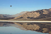
Jet aircraft
A jet aircraft is an aircraft propelled by jet engines. Jet aircraft generally fly much faster than propeller-powered aircraft and at higher altitudes – as high as . At these altitudes, jet engines achieve maximum efficiency over long distances. The engines in propeller-powered aircraft...
have long been common in the valley. The airspace over the valley is part of the US military's vast R-2508 Special Use Airspace complex.http://r2508.edwards.af.mil/index.html The Saline Military Operating Area (MOA) covers the entire valley south to Hunter Mountain from 200' AGL up to FL180 with an ATCAA located over the same area extending from FL180 up to FL600. The airspace is used by military aircraft primarily from Nellis AFB, Edwards AFB, NAWS China Lake, and NAS Lemoore for high and low altitude mission training. Military aircraft utilize radio communications on either 256.8 MHz or 123.95 MHz while operating in the Saline MOA; however, military aircraft throughout the R-2508 complex often use 315.9 MHz when conducting low altitude operations below 1500' AGL.
In December 2003, Edwards Air Force Base
Edwards Air Force Base
Edwards Air Force Base is a United States Air Force base located on the border of Kern County, Los Angeles County, and San Bernardino County, California, in the Antelope Valley. It is southwest of the central business district of North Edwards, California and due east of Rosamond.It is named in...
completed an environmental assessment
Environmental impact assessment
An environmental impact assessment is an assessment of the possible positive or negative impact that a proposed project may have on the environment, together consisting of the natural, social and economic aspects....
for proposed construction and operation of a radar
Radar
Radar is an object-detection system which uses radio waves to determine the range, altitude, direction, or speed of objects. It can be used to detect aircraft, ships, spacecraft, guided missiles, motor vehicles, weather formations, and terrain. The radar dish or antenna transmits pulses of radio...
system and microwave
Microwave
Microwaves, a subset of radio waves, have wavelengths ranging from as long as one meter to as short as one millimeter, or equivalently, with frequencies between 300 MHz and 300 GHz. This broad definition includes both UHF and EHF , and various sources use different boundaries...
repeater facility in the valley. The assessment's conclusion is that "A Finding of No Significant Impact (FONSI) for the alternatives considered has been determined. No potentially significant issues have been identified at any of the five alternative beacon radar sites or any of the three repeater sites considered for the proposed project. A careful review of the environmental issues that have been brought forward to date has not identified any potentially significant issues. Therefore, an Environmental Impact Statement
Environmental impact statement
An environmental impact statement , under United States environmental law, is a document required by the National Environmental Policy Act for certain actions "significantly affecting the quality of the human environment". An EIS is a tool for decision making...
will not be prepared."