

Salinas, Minas Gerais
Encyclopedia

Brazil
Brazil , officially the Federative Republic of Brazil , is the largest country in South America. It is the world's fifth largest country, both by geographical area and by population with over 192 million people...
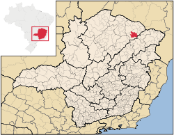
ian state of Minas Gerais
Minas Gerais
Minas Gerais is one of the 26 states of Brazil, of which it is the second most populous, the third richest, and the fourth largest in area. Minas Gerais is the Brazilian state with the largest number of Presidents of Brazil, the current one, Dilma Rousseff, being one of them. The capital is the...
. Its population in 2007 was 37,370 inhabitants in a total area of 1,897 km².
Important facts and Distances
The elevation is 471 meters. It became a municipality in 1880. The postal code (CEP) is 39560-000. Population density was around 18 inhab/km².Salinas is located on highway BR-251. The distance to Montes Claros
Montes Claros
Montes Claros is a city located in northern Minas Gerais state, in Brazil. The estimated population in 2010 was 412,284 inhabitants and the total area of the municipality was 3,470 km²...
is 210 km. The distance to the Rio-Bahia BR-116 is 108 km.
- Important distances: Belo Horizonte/MG 631 km; Vit. da Conquista/BA 250 km; São Paulo/SP 1210 km; Brasília/DF 720 km; and Rio de Janeiro/RJ 1070 km.
Neighboring municipalities
- Neighboring municipalities are: TaiobeirasTaiobeirasTaiobeiras is a municipality in the north of the state of Minas Gerais in Brazil. As of 2007 the population was 29,732 in an area of 1,194 km². The elevation of the municipal seat is 821 meters. It became a municipality in 1953. The postal code is 39550-000 and it belongs to the statistical...
, RubelitaRubelitaRubelita is a municipality in the northeast of the Brazilian state of Minas Gerais. Its population in 2007 was 8,299 inhabitants in a total area of 1,109 km²....
, Santa Cruz de SalinasSanta Cruz de SalinasSanta Cruz de Salinas is a municipality in the northeast of the Brazilian state of Minas Gerais. Its population in 2007 was 5,192 inhabitants in a total area of 587 km²....
, NovorizonteNovorizonteNovorizonte is a municipality in the northeast of the Brazilian state of Minas Gerais. Its population in 2007 was 4,899 inhabitants in a total area of 264 km²....
, Fruta de LeiteFruta de LeiteFruta de Leite is a municipality in the northeast of the Brazilian state of Minas Gerais. As of 2007 the population was 6,327 in a total area of 758 km². The elevation is 910 meters. It became a municipality in 1997. The postal code is 39558-000....
, Rio Pardo de MinasRio Pardo de MinasRio Pardo de Minas is a municipality in the northeast of the Brazilian state of Minas Gerais. Its population in 2007 was 28,633 inhabitants in a total area of 3,119 km².-Important facts and Distances:...
and ComercinhoComercinhoFor Comercinho in the state of Bahia see Comercinho, Bahia.Comercinho is a municipality in the northeast of the Brazilian state of Minas Gerais. Its population in 2007 was 8,720 inhabitants in a total area of 657 km²....
.
Climate
Salinas has a semi-arid climate with high temperatures almost all year round. There is a period of severe drought and another with torrential and sporadic rains. The average summer temperature high is 33°C and the average winter high is 18°C.The economy
The main economic activities are cattle raising (46,000 head in 2006), small industries and agriculture. The main crops are bananas, citrus fruits, mangoes, beans, sugarcane, and corn. The local rum (cachaça) is well-known. In the rural area there were 2,084 producers on 111,541 ha. Natural pasture made up 62,000 ha, woodland 35,000 ha. and planted area 7,500 ha. Around 6,000 persons worked in agriculture.In the urban area there were 4 banking agencies in 2006. The GDP in 2005 was R$157,547.
IBGE statistical microregion
Salinas is also a statistical microregion (53) consisting of 17 municipalities: Águas VermelhasÁguas Vermelhas
Águas Vermelhas is a city in the northeast of the Brazilian state of Minas Gerais. In 2007 its population was estimated to be 12,674 in a total area of 1,258 km²....
, Berizal
Berizal
Berizal is a Brazilian municipality located in the northeast of the state of Minas Gerais. As of 2007 the population was 4,399 in a total area of 493 km²....
, Curral de Dentro
Curral de Dentro
Curral de Dentro is a municipality in the northeast of the Brazilian state of Minas Gerais. As of 2007 the population was 6,907 in a total area of 571 km². The elevation is 890 meters. It became a municipality in 1997....
, Divisa Alegre
Divisa Alegre
Divisa Alegre is a Brazilian municipality located in the northeast of the state of Minas Gerais. As of 2007 the population was 5,793 in a total area of 118 km²....
, Fruta de Leite
Fruta de Leite
Fruta de Leite is a municipality in the northeast of the Brazilian state of Minas Gerais. As of 2007 the population was 6,327 in a total area of 758 km². The elevation is 910 meters. It became a municipality in 1997. The postal code is 39558-000....
, Indaiabira
Indaiabira
Indaiabira is a municipality in the northeast of the Brazilian state of Minas Gerais. As of 2007 the population was 7,482 in a total area of 1,008 km². The elevation is 857 meters. It became a municipality in 1997....
, Montezuma
Montezuma, Minas Gerais
Montezuma is a municipality in the northeast of the Brazilian state of Minas Gerais. As of 2007 the population was 7,259 in a total area of 1,134 km². The elevation is 850 meters. It became a municipality in 1993....
, Ninheira
Ninheira
Ninheira is a city in the northeast of the Brazilian state of Minas Gerais. In 2007 its population was estimated to be 10,414 in a total area of 1,114 km²....
, Novorizonte
Novorizonte
Novorizonte is a municipality in the northeast of the Brazilian state of Minas Gerais. Its population in 2007 was 4,899 inhabitants in a total area of 264 km²....
, Rio Pardo de Minas
Rio Pardo de Minas
Rio Pardo de Minas is a municipality in the northeast of the Brazilian state of Minas Gerais. Its population in 2007 was 28,633 inhabitants in a total area of 3,119 km².-Important facts and Distances:...
, Rubelita
Rubelita
Rubelita is a municipality in the northeast of the Brazilian state of Minas Gerais. Its population in 2007 was 8,299 inhabitants in a total area of 1,109 km²....
, Salinas, Santa Cruz de Salinas
Santa Cruz de Salinas
Santa Cruz de Salinas is a municipality in the northeast of the Brazilian state of Minas Gerais. Its population in 2007 was 5,192 inhabitants in a total area of 587 km²....
, Santo Antônio do Retiro
Santo Antônio do Retiro
Santo Antônio do Retiro is a city in the northeast of the Brazilian state of Minas Gerais. In 2007 its population was estimated to be 6,817 in a total area of 797 km²....
, São João do Paraíso
São João do Paraíso
São João do Paraíso is a city in the northeast of the Brazilian state of Minas Gerais. In 2007 its population was estimated to be 21,839 in a total area of 1,921 km²....
, Taiobeiras
Taiobeiras
Taiobeiras is a municipality in the north of the state of Minas Gerais in Brazil. As of 2007 the population was 29,732 in an area of 1,194 km². The elevation of the municipal seat is 821 meters. It became a municipality in 1953. The postal code is 39550-000 and it belongs to the statistical...
, Vargem Grande do Rio Pardo
Vargem Grande do Rio Pardo
Vargem Grande do Rio Pardo is a municipality in the northeast of the Brazilian state of Minas Gerais. As of 2007 the population was 4,703 in a total area of 494 km². The elevation is 800 meters...
. The population of this region was 180,136 in 2000 and the area is 17,883.30 km².
Health and education
This municipality is isolated from major population centers and suffers from drought and poor soils.- Municipal Human Development IndexHuman Development IndexThe Human Development Index is a composite statistic used to rank countries by level of "human development" and separate "very high human development", "high human development", "medium human development", and "low human development" countries...
: .699 (2000) - State ranking: 551 out of 853 municipalities as of 2000
- National ranking: 3,015 out of 5,138 municipalities as of 2000
(For the complete list see
- Degree of urbanization: 71.56%
- Infant mortality rate: 21.28 (2003) The rate for Minas Gerais was 17.40; the rate for Brazil was 18.91.
- Illiteracy rate: 23.85% (15 years old or older)(2003) The rate for Minas Gerais was 11.96; the rate for Brazil was 13.63
- Urban area covered by sewage system: 60.60%--the rate for Minas Gerais was 81.39%
- Health clinics, health centers, and hospitals: 4, 6, 4 with 175 beds