

Saint Peter Islands
Encyclopedia
Tundra
In physical geography, tundra is a biome where the tree growth is hindered by low temperatures and short growing seasons. The term tundra comes through Russian тундра from the Kildin Sami word tūndâr "uplands," "treeless mountain tract." There are three types of tundra: Arctic tundra, alpine...
vegetation, shingle
Shingle beach
A shingle beach is a beach which is armoured with pebbles or small- to medium-sized cobbles. Typically, the stone composition may grade from characteristic sizes ranging from two to 200 mm diameter....
and ice. These islands, as well as some other islands nearby (Ostrova Andreia, Ostrov Pavla) were originally named after Christian Apostles.
The Saint Peter Islands are surrounded by narrow beach ridges and swale
Swale
Swale is a local government district with borough status in Kent, England. Its council is based in Sittingbourne. The borough is named after the narrow channel called The Swale, a channel that separates the mainland of Kent from the Isle of Sheppey, and which occupies the central part of the...
s. They are located in the Laptev Sea
Laptev Sea
The Laptev Sea is a marginal sea of the Arctic Ocean. It is located between the northern coast of Siberia, the Taimyr Peninsula, Severnaya Zemlya and the New Siberian Islands. Its northern boundary passes from the Arctic Cape to a point with co-ordinates of 79°N and 139°E, and ends at the Anisiy...
coastal region, off the eastern shores of the Taymyr Peninsula
Taymyr Peninsula
The Taymyr Peninsula is a peninsula in the Far North of Russia, in the Siberian Federal District, that forms the northernmost part of mainland Eurasia and Asia...
, between Bukhta Marii Pronchishchevoy and Bukhta Faddeya
Faddey Bay
The Faddey Bay is a gulf in the Laptev Sea on the eastern coast of the Taymyr Peninsula. It measures about 47 km from its innermost point in the southwest, the delta of the Pregradnaya River, to its broadest opening to the sea in the northeast...
.
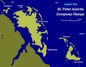
- The largest island is Ostrov Petr-Severnyy with a surface of 175 km². It is located very close to the coast, separated from it by a sound that is only 1.2 km wide in its narrowest point. The latitude of this island is 76° 40' N and its longitude 112° 25' E.
- Ostrov Petr-Yuzhnyy is significantly smaller than its northern neighbor. It is located 9 km to the SW of Ostrov Petr-Severnyy and it is farther offshore. The latitude is 76° 20' N and its longitude 113° 15' E.
Other lesser islands in the Saint Peter group are Dozhdevoy, Vstrech, Bezymyannyy, Serpovidnyy and Kleshnya.
The climate is Arctic and severe with frequent blizzards in the winter. The sea surrounding these Islands is covered with fast ice most of the year and is obstructed by pack ice even in the summer, so that these islands are merged with the mainland and animals can go across the ice.
This island group belongs to the Krasnoyarsk Krai
Krasnoyarsk Krai
Krasnoyarsk Krai is a federal subject of Russia . It is the second largest federal subject after the Sakha Republic, and Russia's largest krai, occupying an area of , which is 13% of the country's total territory. The administrative center of the krai is the city of Krasnoyarsk...
administrative division of Russia
Russia
Russia or , officially known as both Russia and the Russian Federation , is a country in northern Eurasia. It is a federal semi-presidential republic, comprising 83 federal subjects...
.
Other coastal islands
- Saint Andrew Island (Остров Андрея; Ostrov Andreia) is an island of similar characteristics lying about 40 km further northwest along the coast. This island, Paul Island (Остров Павла; Ostrov Pavla) and Koshka Island (Остров Кошка; Ostrov Koshka), a neighboring long and narrow coastal island, are sometimes included as part of the same group, the Saint Andrew Islands (Острова Андрея; Ostrova Andreia).
- Vos'mogo Marta Island (Остров Восьмого Марта) is located only 8.5 km to the south of Petr-Yuzhnyy's SW end.
- Psov Island (Остров Псов) is 4 km long and 3 km wide. It lies further down the coast, 43 km from Petr-Yuzhnyy's southeastern point.
None of these islands have had much historical importance, except for the fact that they are located very close to the Northern Sea Route
Northern Sea Route
The Northern Sea Route is a shipping lane officially defined by Russian legislation from the Atlantic Ocean to the Pacific Ocean specifically running along the Russian Arctic coast from Murmansk on the Barents Sea, along Siberia, to the Bering Strait and Far East. The entire route lies in Arctic...
.