

Sabalana Islands
Encyclopedia
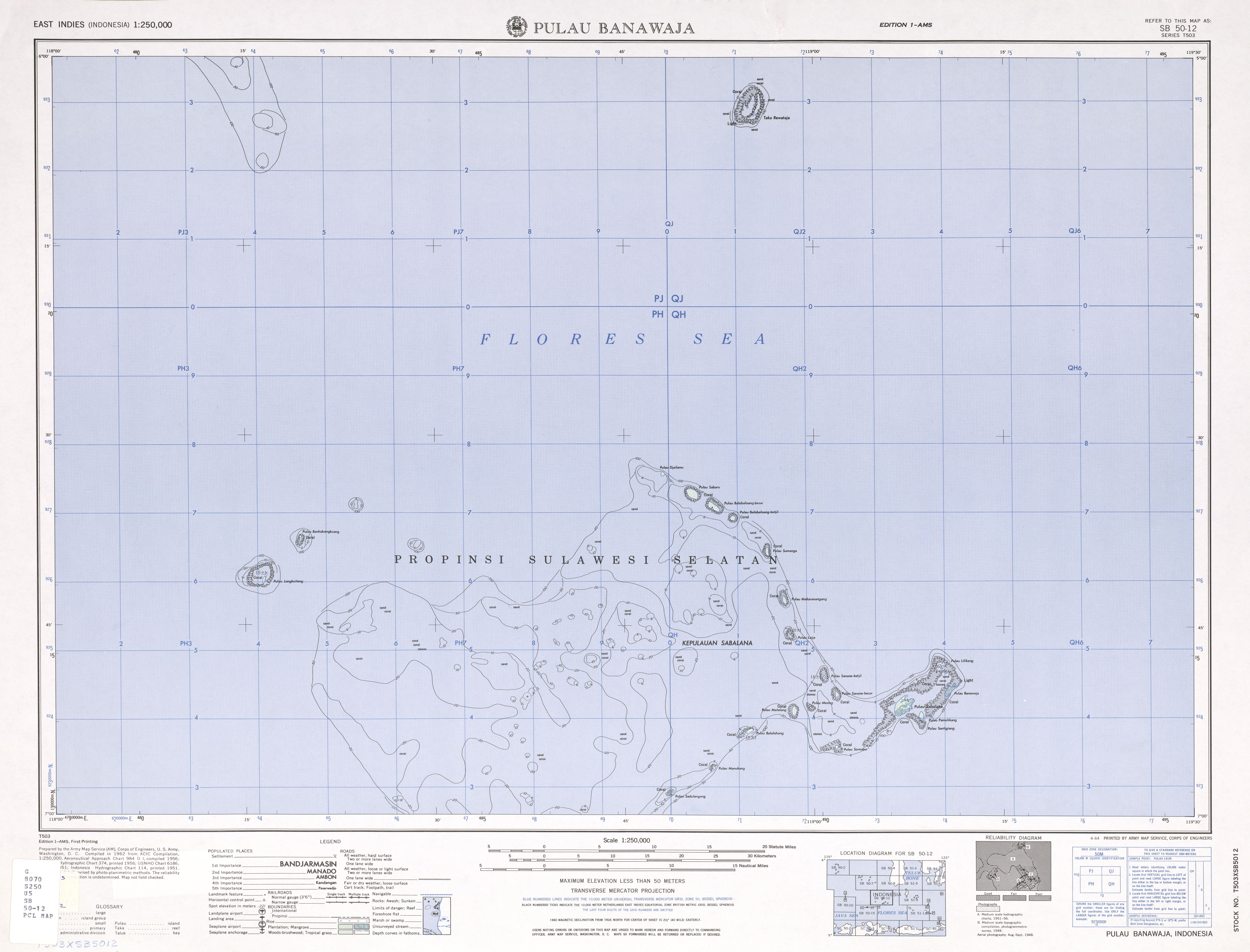
The Sabalana Islands are an Atoll
in the Flores Sea
in Indonesia, lying just north of the Lesser Sunda Islands
, closer to Sumbawa
than Sulawesi
. They are west of Tanahjampea Island and northeast of the Tengah Islands
(Central Islands). Administratively, the atoll belongs to the province of South Sulawesi
. The total area, including the large lagoon
, is 2694 km², making Sabalana one of the largest atolls by total area. The land area of the largest individual island, Pulau Sabalana, measures about 7 km², followed by Pulau Banawaja with 3 km² and Pulau Sabaru with 1.4 km².
The individual islets are listed, clockwise from the northernmost to the southernmost (the western rim of the atoll is free of islets):
Atoll
An atoll is a coral island that encircles a lagoon partially or completely.- Usage :The word atoll comes from the Dhivehi word atholhu OED...
in the Flores Sea
Flores Sea
The Flores Sea covers 93,000 square miles of water in Indonesia.- Geography :The seas that border the Flores Sea are the Bali Sea , Java Sea , and the Banda Sea ....
in Indonesia, lying just north of the Lesser Sunda Islands
Lesser Sunda Islands
The Lesser Sunda Islands or Nusa Tenggara are a group of islands in the southern Maritime Southeast Asia, north of Australia. Together with the Greater Sunda Islands to the west they make up the Sunda Islands...
, closer to Sumbawa
Sumbawa
Sumbawa is an Indonesian island, located in the middle of the Lesser Sunda Islands chain, with Lombok to the west, Flores to the east, and Sumba further to the southeast. It is in the province of West Nusa Tenggara....
than Sulawesi
Sulawesi
Sulawesi is one of the four larger Sunda Islands of Indonesia and is situated between Borneo and the Maluku Islands. In Indonesia, only Sumatra, Borneo, and Papua are larger in territory, and only Java and Sumatra have larger Indonesian populations.- Etymology :The Portuguese were the first to...
. They are west of Tanahjampea Island and northeast of the Tengah Islands
Tengah Islands
Tengah Islands are a group of islands in the Flores Sea in Indonesia, lying just north of the Lesser Sunda Islands, scattered off the north coast of Mount Tambora in Sumbawa. They are southwest of the Sabalana Islands....
(Central Islands). Administratively, the atoll belongs to the province of South Sulawesi
South Sulawesi
South Sulawesi is a province of Indonesia, located on the western southern peninsula of Sulawesi Island. The province is bordered by Central Sulawesi province to the north, South East Sulawesi province to the east and West Sulawesi province to the west...
. The total area, including the large lagoon
Lagoon
A lagoon is a body of shallow sea water or brackish water separated from the sea by some form of barrier. The EU's habitat directive defines lagoons as "expanses of shallow coastal salt water, of varying salinity or water volume, wholly or partially separated from the sea by sand banks or shingle,...
, is 2694 km², making Sabalana one of the largest atolls by total area. The land area of the largest individual island, Pulau Sabalana, measures about 7 km², followed by Pulau Banawaja with 3 km² and Pulau Sabaru with 1.4 km².
The individual islets are listed, clockwise from the northernmost to the southernmost (the western rim of the atoll is free of islets):
- Pulau Djailamu
- Pulau Sabaru
- Pulau Balobaloang-besar
- Pulau Balobaloang-ketjil
- Pulau Sumanga
- Pulau Makaranangang
- Pulau Laija
- Pulau Sanane-ketjil
- Pulau Sanane-besar
- Pulau Sabalana
- Pulau Banawaja (easternmost)
- Pulau Pamolikang
- Pulau Santigiang
- Pulau Soroabu
- Pulau Meong
- Pulau Matalang
- Pulau Balalohong
- Pulau Manukang
- Pulau Sadulangang
- Pulau Sarege