
Sa Pa
Encyclopedia
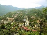
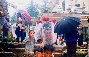
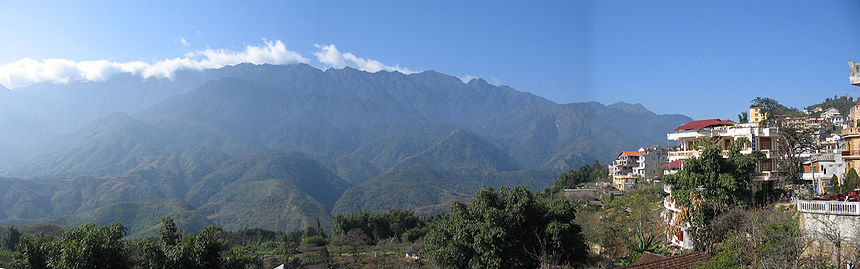
Sa Pa or Sapa, is a frontier town and capital of Sa Pa District
in the Lao Cai province
in northwest Vietnam
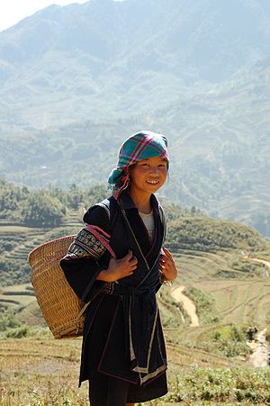
. It is one of the main market towns in the area, where several ethnic minority groups such as Hmong
, Dao (Yao), Giay, Pho Lu, and Tay live.
and Yao groups, as well as by smaller numbers of Tày and Giay. These are the four main minority groups still present in Sa Pa district today. The Kinh (lowland Vietnamese) never originally colonised this highest of Việt Nam’s valleys, which lies in the shadow of Phan-Xi-Pǎng
(Fansipan, 3143 meters), the highest peak in the country.
It was only when the French debarked in highland Tonkin
in the late 1880s that Sa Pa, or Chapa (from Chinese Xa Pa, the "sandy place")as the French called it, began to appear on the national map. In the following decade, the future site of Sa Pa town started to see military parties as well as missionaries from the Société des Missions Etrangères de Paris (MEP) visit. The French military marched from the Red River Delta into the northern mountainous regions as part of Tonkin’s ‘pacification’. In 1894-96 the border between China and Tonkin was formally agreed upon and the Sa Pa area, just to the south of this frontier, was placed under French authority. From 1891 the entire Lào Cai
region, including Sa Pa, came under direct colonial military administration so as to curtail banditry and political resistance on the sensitive northern frontier.
The first permanent French civilian resident arrived in Sa Pa in 1909. With its attractive continental climate, health authorities believed the site had potential. By 1912 a military sanatorium
for ailing officers had been erected along with a fully fledged military garrison. Then, from the 1920s onwards, several wealthy professionals with enough financial capital also had a number of private villas built in the vicinity.
At the end of the Second World War a long period of hostilities began in Tonkin that was to last until 1954. In the process, nearly all of the 200 or so colonial buildings in or around Sa Pa were destroyed, either by Việt Minh sympathisers in the late 1940s, or, in the early 1950s by French air raids. The vast majority of the Viet population fled for their lives, and the former town entered a prolonged sleep.
 In the early 1960s, thanks to the New Economic Zones migration scheme set up by the new Socialist regime, new inhabitants from the lowlands started to migrate to the region.
The short 1979 occupation of the northern border region by Chinese troops
had little impact on Sa Pa town, but did force the Kinh (lowland Vietnamese) population out for a month.
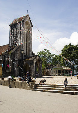
In 1993 the last obstacle to Sa Pa's full rebirth as a prominent holiday destination was lifted as the decision was made to open the door fully to international tourism. Sa Pa was back on the tourist trail again, this time for a newly emerging local elite tourist crowd, as well as international tourists.
In 2006, the Chairman of The People's Committee of Sapa Province was elected to The Communist Party Central Committee as the youngest ever member (born in 1973).
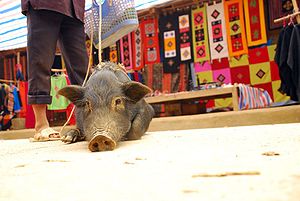
 Sa Pa is a quiet mountain town and home to a great diversity of ethnic minority peoples. The total population of 36,000 consists mostly of minority groups. Besides the Kinh (Viet) people (15%) there are mainly 5 ethnic groups in Sapa: Hmong 52%, Dao 25%, Tay 5%, Giay 2% and a small number of Xa Pho. Approximately 7,000 live in Sapa, the other 36,000 being scattered in small communes throughout the district.
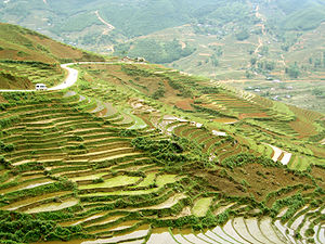
Most of the ethnic minority people work their land on sloping terraces since the vast majority of the land is mountainous. Their staple foods are rice and corn. Rice, by its very nature of being a labour intensive crop, makes the daily fight for survival paramount. The unique climate in Sapa has a major influence on the ethnic minorities who live in the area. With sub-tropical summers, temperate winters and 160 days of mist annually, the influence on agricultural yields and health related issues are significant.
The minority people can only yield one crop of rice annually, which leads to food shortfalls in many communes at specific times. This shortage of food contributes to malnutrition and other related health problems. The climatic conditions also contribute to many health issues including coughs, colds, and bronchial and respiratory problems that are commonplace throughout the community.
The geographical location of the area makes it a truly unique place for many interesting plants and animals, allowing it to support many inhabitants. Many very rare or even endemic species have been recorded in the region.
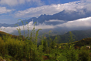
 The scenery of the Sa Pa region in large part reflects the relationship between the minority people and nature. This is seen especially in the paddy fields carpeting the rolling lower slopes of the Hoang Lien Mountains. The impressive physical landscape which underlies this has resulted from the work of the elements over thousands of years, wearing away the underlying rock. On a clear day, the imposing peak of Fan Si Pan comes into view. The last major peak in the Himalayan chain, Fan Si Pan offers a real challenge to even the keenest walker, the opportunity of staggering views, and a rare glimpse of some of the last remaining primary rain forest in Vietnam.
Geology, climate and human activity have combined to produce a range of very distinct habitats around Sa Pa. Especially important is Sa Pa’s geographic position, at the convergence of the worlds 14 “biomes” (distinct biographic areas), producing an assemblage of plant and animal species unique in the world.
 The Hoang Lien Mountains are home to a rich variety of plants, birds, mammals, amphibians, reptiles and insects, many only found in northwestern Vietnam. For this reason, the Hoang Lien Nature Reserve was made a National Park
in 2006, and covers much of the mountain range to the immediate south of Sa Pa.
Forest type and quality change with increasing altitude. At 2000 meters the natural, undisturbed forest begins to be seen. Above 2500 meters dwarf conifers and rhododendrons predominate in the harsh “elfin forest”, so called because a lack of topsoil and nutrients means that fully mature trees grow to measure only a few meters in height. Higher still, only the hardiest of plant species are found. At over 3000 meters, Fan Si Pan’s summit can only support dwarf bamboo.
 The climate of Hoang Lien National Park is unique to Vietnam. It is highly seasonal, with a subtropical climate in the summer and a temperate climate during the winter. Mean annual temperature for Sa Pa town is 15.4°C, with a maximum of 29.4°C and a minimum of 1°C. The warmest months are July and August, and the coldest months are December and January. Snow falls in some years on the highest peaks.
In common with the rest of northern Vietnam, Hoang Lien National Park experiences a marked wet season from May to September, with the heaviest rainfall occurring in July and August. Mean annual rainfall is 2,763mm, with a high of 4,023mm and a low of 2,064mm. Humidity ranges from 75 to 91 percent with a yearly mean of 86 percent.
Climate varies considerably within the national park. The prevalent wind direction for most of the year is west to east, leading to cloud formation on the upper slopes of the Fansipan massif. These high-altitude areas are covered by cloud most days of the year and have very high humidity. Cloud also penetrates into the valleys but these areas are usually less humid than the mountain slopes. In the extreme east of the national park, around Ban Ho village, mean temperatures are considerably higher due to the lower altitude of these areas.
 The geology of Hoang Lien National Park includes metamorphosed sediments and a granitic intrusion. The metamorphosed sediments strike from northwest to southeast along the Muong Hoa valley. On the northeastern side of the valley is a craggy ridge of marble and metamorphosed carbonate rocks that exhibit a karst style of weathering. These formations are currently being quarried for road building. The valley floor is characterised by schist and, to a lesser extent, gneiss. The granitic intrusion extends from the Muong Hoa River to the summit ridge of Fansipan and beyond. Due to the high humidity and rainfall in the area, chemical weathering is prevalent. This is reflected in the clay nature of the soil.
 Before the 1990s, the town's economy was mainly based on small size agriculture.
Tourist arrival between 1995 and 2003 grew from a total of 4860 to 138,622. On average, this cohort is made of 79% Vietnamese and 21% foreigners.
In addition to the forest habitats, the national park contains large areas of agricultural land, scrub land and Savannah. Agriculture is concentrated at altitudes below 1,500m, in the bottom of valleys. Scrub land and Savannah areas are found where forest has been cleared: around the edge of cultivated areas and on ridge tops, which have been subjected to burning.
A final vegetation type represented at Hoang Lien National Park is dwarf bamboo. This habitat is confined to the highest ridges of the Fansipan massif, at altitudes above 2,800 m.
Sa Pa District
Sa Pa is a district huyện of Lao Cai province in the Northeastern region of Vietnam.As of 2003 the district had a population of 42,095. The district covers an area of 677 km²...
in the Lao Cai province
Lao Cai Province
Lào Cai , is a province of northeastern in the mountainous region of Vietnam, bordering the province of Yunnan in the China. The province covers an area of 6383.9 square kilometres and as of 2008 it had a population of 602,300 people....
in northwest Vietnam
Vietnam
Vietnam – sometimes spelled Viet Nam , officially the Socialist Republic of Vietnam – is the easternmost country on the Indochina Peninsula in Southeast Asia. It is bordered by China to the north, Laos to the northwest, Cambodia to the southwest, and the South China Sea –...
. It is one of the main market towns in the area, where several ethnic minority groups such as Hmong
Hmong people
The Hmong , are an Asian ethnic group from the mountainous regions of China, Vietnam, Laos, and Thailand. Hmong are also one of the sub-groups of the Miao ethnicity in southern China...
, Dao (Yao), Giay, Pho Lu, and Tay live.
History
It is most likely that Sa Pa was first inhabited by highland minorities of the HmongHmong people
The Hmong , are an Asian ethnic group from the mountainous regions of China, Vietnam, Laos, and Thailand. Hmong are also one of the sub-groups of the Miao ethnicity in southern China...
and Yao groups, as well as by smaller numbers of Tày and Giay. These are the four main minority groups still present in Sa Pa district today. The Kinh (lowland Vietnamese) never originally colonised this highest of Việt Nam’s valleys, which lies in the shadow of Phan-Xi-Pǎng
Fansipan
Fansipan is a mountain in Vietnam, the highest in Indochina, at . It is located in the Lào Cai province of Northwest Vietnam, 9 km southwest of Sa Pa Township in the Hoang Lien Son mountain range....
(Fansipan, 3143 meters), the highest peak in the country.
It was only when the French debarked in highland Tonkin
Tonkin
Tonkin , also spelled Tongkin, Tonquin or Tongking, is the northernmost part of Vietnam, south of China's Yunnan and Guangxi Provinces, east of northern Laos, and west of the Gulf of Tonkin. Locally, it is known as Bắc Kỳ, meaning "Northern Region"...
in the late 1880s that Sa Pa, or Chapa (from Chinese Xa Pa, the "sandy place")as the French called it, began to appear on the national map. In the following decade, the future site of Sa Pa town started to see military parties as well as missionaries from the Société des Missions Etrangères de Paris (MEP) visit. The French military marched from the Red River Delta into the northern mountainous regions as part of Tonkin’s ‘pacification’. In 1894-96 the border between China and Tonkin was formally agreed upon and the Sa Pa area, just to the south of this frontier, was placed under French authority. From 1891 the entire Lào Cai
Lao Cai
Lào Cai is a city in northeastern Vietnam. It is the capital of Lao Cai province. The city borders the city of Hekou, in the Yunnan province of Southwest China. It lies at the junction of the Red River and the Nam Ti River approximately 160 miles northwest of Hanoi...
region, including Sa Pa, came under direct colonial military administration so as to curtail banditry and political resistance on the sensitive northern frontier.
The first permanent French civilian resident arrived in Sa Pa in 1909. With its attractive continental climate, health authorities believed the site had potential. By 1912 a military sanatorium
Sanatorium
A sanatorium is a medical facility for long-term illness, most typically associated with treatment of tuberculosis before antibiotics...
for ailing officers had been erected along with a fully fledged military garrison. Then, from the 1920s onwards, several wealthy professionals with enough financial capital also had a number of private villas built in the vicinity.
At the end of the Second World War a long period of hostilities began in Tonkin that was to last until 1954. In the process, nearly all of the 200 or so colonial buildings in or around Sa Pa were destroyed, either by Việt Minh sympathisers in the late 1940s, or, in the early 1950s by French air raids. The vast majority of the Viet population fled for their lives, and the former town entered a prolonged sleep.
The short 1979 occupation of the northern border region by Chinese troops
Sino-Vietnamese War
The Sino–Vietnamese War , also known as the Third Indochina War, known in the PRC as and in Vietnam as Chiến tranh chống bành trướng Trung Hoa , was a brief but bloody border war fought in 1979 between the People's Republic of China and the Socialist Republic of Vietnam...
had little impact on Sa Pa town, but did force the Kinh (lowland Vietnamese) population out for a month.
In 1993 the last obstacle to Sa Pa's full rebirth as a prominent holiday destination was lifted as the decision was made to open the door fully to international tourism. Sa Pa was back on the tourist trail again, this time for a newly emerging local elite tourist crowd, as well as international tourists.
In 2006, the Chairman of The People's Committee of Sapa Province was elected to The Communist Party Central Committee as the youngest ever member (born in 1973).
Geography
Sa Pa District is located in Lao Cai Province, north-west Vietnam, and 350 km north-west of Hanoi, close to the border with China. The Hoang Lien Son range of mountains dominates the district, which is at the eastern extremity of the Himalayas. This range includes Vietnam's highest mountain, Fan Si Pan, at a height of 3142m above sea level. The town of Sa Pa lies at an altitude of about 1600 m. The climate is moderate and rainy in summer (May—August), and foggy and cold with occasional snowfalls in winter.Most of the ethnic minority people work their land on sloping terraces since the vast majority of the land is mountainous. Their staple foods are rice and corn. Rice, by its very nature of being a labour intensive crop, makes the daily fight for survival paramount. The unique climate in Sapa has a major influence on the ethnic minorities who live in the area. With sub-tropical summers, temperate winters and 160 days of mist annually, the influence on agricultural yields and health related issues are significant.
The minority people can only yield one crop of rice annually, which leads to food shortfalls in many communes at specific times. This shortage of food contributes to malnutrition and other related health problems. The climatic conditions also contribute to many health issues including coughs, colds, and bronchial and respiratory problems that are commonplace throughout the community.
The geographical location of the area makes it a truly unique place for many interesting plants and animals, allowing it to support many inhabitants. Many very rare or even endemic species have been recorded in the region.
Geology, climate and human activity have combined to produce a range of very distinct habitats around Sa Pa. Especially important is Sa Pa’s geographic position, at the convergence of the worlds 14 “biomes” (distinct biographic areas), producing an assemblage of plant and animal species unique in the world.
Ecological life
Hoang Lien National Park
Hoang Lien National Park is a national park within Hoang Lien Son Range, in the districts of Sa Pa, Than Uyên of Lào Cai Province, and part of Phong Thổ District in Lai Châu Province....
in 2006, and covers much of the mountain range to the immediate south of Sa Pa.
Forest type and quality change with increasing altitude. At 2000 meters the natural, undisturbed forest begins to be seen. Above 2500 meters dwarf conifers and rhododendrons predominate in the harsh “elfin forest”, so called because a lack of topsoil and nutrients means that fully mature trees grow to measure only a few meters in height. Higher still, only the hardiest of plant species are found. At over 3000 meters, Fan Si Pan’s summit can only support dwarf bamboo.
Topography
The Hoang Lien Mountains lie at the southeastern extent of the Himalayan chain. The national park is located on the northeast flank of these mountains and includes Vietnam’s highest peak, Fansipan, at 3,143 m (see map). The lowest point is 380 m but most of the national park lies above 1,000 m. The flanks of the mountains are very steep and many areas are almost inaccessible on foot. Between Fansipan Mountain and Sa Pa town, lies the Muong Hoa valley, which has been terraced for wet rice agriculture. This valley becomes wider towards the east of the national park.Climate
In common with the rest of northern Vietnam, Hoang Lien National Park experiences a marked wet season from May to September, with the heaviest rainfall occurring in July and August. Mean annual rainfall is 2,763mm, with a high of 4,023mm and a low of 2,064mm. Humidity ranges from 75 to 91 percent with a yearly mean of 86 percent.
Climate varies considerably within the national park. The prevalent wind direction for most of the year is west to east, leading to cloud formation on the upper slopes of the Fansipan massif. These high-altitude areas are covered by cloud most days of the year and have very high humidity. Cloud also penetrates into the valleys but these areas are usually less humid than the mountain slopes. In the extreme east of the national park, around Ban Ho village, mean temperatures are considerably higher due to the lower altitude of these areas.
Geology
Economy
Tourist arrival between 1995 and 2003 grew from a total of 4860 to 138,622. On average, this cohort is made of 79% Vietnamese and 21% foreigners.
Hydrology
Hoang Lien National Park is drained by the Muong Hoa and Ta Trung Ho rivers, which feed the Nam Po River and, finally, the Song Hong (Red) river. The forest has an essential role in water catchment protection, particularly the forest at high altitudes, which is frequently covered in cloud. Water condenses on the vegetation and falls as ‘occult’ precipitation. Occult precipitation makes a major contribution to stream-flow during the dry season when rainfall is low.Vegetation
The forest of Hoang Lien National Park can be classified as belonging to 3 types: sub-montane dry evergreen forest, tropical montane deciduous forest and sub-alpine forest. The sub-montane dry evergreen forest, which occurs at lower altitudes, has been the most heavily disturbed by the activities of man.In addition to the forest habitats, the national park contains large areas of agricultural land, scrub land and Savannah. Agriculture is concentrated at altitudes below 1,500m, in the bottom of valleys. Scrub land and Savannah areas are found where forest has been cleared: around the edge of cultivated areas and on ridge tops, which have been subjected to burning.
A final vegetation type represented at Hoang Lien National Park is dwarf bamboo. This habitat is confined to the highest ridges of the Fansipan massif, at altitudes above 2,800 m.