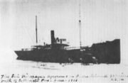
SS Nicaragua
Encyclopedia

Ship
Since the end of the age of sail a ship has been any large buoyant marine vessel. Ships are generally distinguished from boats based on size and cargo or passenger capacity. Ships are used on lakes, seas, and rivers for a variety of activities, such as the transport of people or goods, fishing,...
that was sailing in the Gulf of Mexico
Gulf of Mexico
The Gulf of Mexico is a partially landlocked ocean basin largely surrounded by the North American continent and the island of Cuba. It is bounded on the northeast, north and northwest by the Gulf Coast of the United States, on the southwest and south by Mexico, and on the southeast by Cuba. In...
when it ran aground on Padre Island
Padre Island
Padre Island is part of the U.S. state of Texas. The island is located on Texas' southern coast of the Gulf of Mexico and is famous for its white sandy beaches at the south end...
in 1912.
During the nineteenth and early twentieth centuries, Padre Island was the site of a number of shipwrecks. "Devil's Elbow," is a point of tidal convergence around milepost 50 from Malaquite Beach of the north island, wrecked many vessels. One of these was the Nicaragua. This ship, bound from Port Arthur, Texas
Port Arthur, Texas
-Demographics:As of the 2000 census, there were 57,755 people, 21,839 households, and 14,675 families residing in the city. The population density was 696.5 people per square mile . There were 24,713 housing units at an average density of 298.0 per square mile...
, for Tampico, Tamaulipas was wrecked on 16 October 1912. The stern, engine room section and masthead of the vessel remained visible off the island for many years, serving as a landmark for down-island travelers. Rumors have arisen about the gun running and illegal activities it might have performed, however there is no evidence of the ship's true mission that October evening.
The remaining structure of the ship can be seen at low tide.
The ship was built in 1891 in Bergen, Norway, and her plans show that she was 190 feet overall. Lloyd’s of London [illegible] at 611 gross tons.
Carrying cotton and miscellaneous cargo, she left Tampico bound for Port Arthur. Five days later, on Oct. 16, 1912, during a storm that sank vessels all over the Gulf of Mexico, the Nicaragua went down on the shores of Padre Island, in that section of the coast known as the Devil’s Elbow.

