
.gif)
Route 7 (New Jersey)
Encyclopedia
Route 7 is a state highway
in the northern part of New Jersey
in the United States
. It has two sections, an east–west alignment running from U.S. Route 1/9 Truck in Jersey City
to Route 21 in Belleville
, and a north–south alignment running from the Newark
/Belleville to the Nutley
/Clifton
border, and is one of two state highways in New Jersey to have an intentional discontinuity (New Jersey Route 440 is the other). The New Jersey Department of Transportation
lists Route 7 as a single north–south highway with a small gap between the alignments. The entire highway has a combined length of 10.16 mi (16.35 km).
The southern section of Route 7, which runs from Jersey City to Belleville, passes through industrial areas, the New Jersey Meadowlands
, Arlington Memorial Park
, and some residential and business areas. West of the interchange with County Route 508
in Kearny
, Route 7 is the Belleville Turnpike, a historic road created in 1759. The northern section of Route 7 runs north through residential and business areas of Belleville and Nutley into Clifton, where it turns west and crosses back into Nutley, briefly turning to the north to come to its northern terminus. A portion of the route in Nutley is municipally maintained while the portion within Clifton is maintained by Passaic County
. The two separate sections of Route 7 are linked by County Route 506
(Rutgers Street) in Belleville, which is signed as Route 7 despite the fact it is not officially part of the route.
Route 7 was established in 1927 to run from Jersey City
to Paterson
, replacing Pre-1927 Route 11 between Belleville and Paterson. The routing was amended in 1929 to head to Route 3 in Wallington
and was extended north to Route 6 (now U.S. Route 46
) in East Paterson in 1949. In 1953, the route was modified to follow its current alignment.
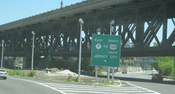 The first section of Route 7 begins at an intersection with U.S. Route 1-9 Truck and County Route 645 (Charlotte Avenue) in Jersey City
, Hudson County
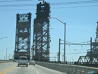
, heading to the west on a four-lane highway that is signed east–west. The route crosses the Hackensack River
on the Wittpenn Bridge
into Kearny
. Route 7 interchanges with County Route 659 (Fish House Road) and widens to a six-lane divided highway
. The route than passes by industrial areas and a railroad yard and then interchanges with County Route 508
. Past this interchange, Route 7 becomes the four-lane, divided Belleville Turnpike. The route narrows to a two-lane, undivided road and heads northwest into the New Jersey Meadowlands
, passing under the mainline of the New Jersey Turnpike
(Interstate 95
) and the western spur of the New Jersey Turnpike a short distance later.
Route 7 continues northwest, widens into a divided highway, and forms the border of Kearny to the south and North Arlington
, Bergen County
to the north, entering a more residential environment. The route is signed north–south along the border of Kearny and North Arlington. The road intersects Schuyler Avenue, which runs as County Route 507
to the south of Route 7 and County Route 130 to the north of Route 7. County Route 507 joins Route 7 at this intersection and the two routes continue west, meeting the southern terminus of Route 17 (Ridge Road) and the northern terminus of County Route 697 (Kearny Avenue). Past this intersection, County Route 507 splits from Route 7 by heading north on River Road, County Route 699 heads to the south on Passaic Avenue, and Route 7 continues west, crossing the Passaic River
on a drawbridge
into Belleville
, Essex County
, where the first section of Route 7 ends at an intersection with Route 21.
crossing on the Newark
/Belleville
border, passing through a business district. The route intersects County Route 506
(Belleville Avenue), and that route forms a concurrency
with Route 7 that lasts one block to the intersection with Rutgers Street, where County Route 506 heads to the east. Rutgers Street is used to connect the two sections of Route 7 and is named for Colonel Henry Rutgers
, an American Revolutionary War
hero and benefactor of what is now Rutgers University
. It is signed as but not officially part of Route 7. Route 7 is not signed on Washington Avenue between the Second River and Rutgers Street except on overhead signs suspended from traffic signals.
From Rutgers Street, Route 7 continues north, crossing into Nutley
. At the intersection with County Route 646 (Park Avenue), Route 7 turns into a municipally maintained road and enters a more residential area. Upon intersecting County Route 606 (Kingsland Road), Route 7 crosses into Clifton
, Passaic County
and heads to the west on county-maintained Kingsland Street signed east–west. It crosses back into Nutley, Essex County and regains state maintenance. At the intersection with County Route 644, Route 7 turns north onto Cathedral Avenue and comes to its terminus at the Nutley/Clifton border less than one-half mile from an interchange with Route 3.
 The Belleville Turnpike was created in 1759 as a turnpike
made out of cedar logs and was chartered in 1808. It served as a part of the Underground Railroad
route for escaped slaves to get to Jersey City
. The northern segment of Route 7 was originally a part of Pre-1927 Route 11, which was legislated in 1917 to run from Newark
to Paterson
. In the 1927 New Jersey state highway renumbering
, Route 7 was designated to run from Jersey City
to Paterson, replacing Pre-1927 Route 11 between Belleville
and Paterson.
In 1929, the routing was amended to run from Route 25 (now U.S. Route 1/9 Truck) in Jersey City to Route 3 in Wallington
. Route 7 was extended north in 1949 to continue to Route 6 (now U.S. Route 46
) in East Paterson (now Elmwood Park
). In the 1953 New Jersey state highway renumbering
, Route 7 was legislated onto its current alignment, with the northern terminus moved to the Nutley
/Clifton
border. The route was also realigned to head south on Washington Avenue between the Newark border and Rutgers Street in Belleville on what was Route 11N, a remnant of Pre-1927 Route 11, making Route 7 discontinuous. County Route 506
used to follow the southern portion of Route 7 but has been truncated to the intersection with Routes 7 and 21 in Belleville.
|-
!County
!Location
!Mile
!Road(s)
!Notes
|-
|rowspan=4|Hudson
|rowspan=2|Jersey City
|0.00
|
|Eastern terminus
|-
|0.42
|colspan=5 align="center"|Wittpenn Bridge
over Hackensack River
|-
|rowspan=2|Kearny
|0.56
|
|Interchange
|-
|1.40
|
|Interchange
|-
|rowspan=3|Hudson
/Bergen
|rowspan=3|Kearny
/North Arlington
|4.22
|
|South end of CR 507 overlap
|-
|4.74
|
|
|-
|5.22
|
|North end of CR 507 overlap
|-
|rowspan=5|Essex
|rowspan=4|Belleville
|5.35
|
|Interchange; Northern terminus of first section
|-
|6.05
|Newark
/Belleville
border
|Southern terminus of second section
|-
|6.40
|
|South end of CR 506 overlap
|-
|6.48
|
|North end of CR 506 overlap
|-
|Nutley
|10.16
|Nutley
/Clifton
border
|Northern terminus
|-
State highway
State highway, state road or state route can refer to one of three related concepts, two of them related to a state or provincial government in a country that is divided into states or provinces :#A...
in the northern part of New Jersey
New Jersey
New Jersey is a state in the Northeastern and Middle Atlantic regions of the United States. , its population was 8,791,894. It is bordered on the north and east by the state of New York, on the southeast and south by the Atlantic Ocean, on the west by Pennsylvania and on the southwest by Delaware...
in the United States
United States
The United States of America is a federal constitutional republic comprising fifty states and a federal district...
. It has two sections, an east–west alignment running from U.S. Route 1/9 Truck in Jersey City
Jersey City, New Jersey
Jersey City is the seat of Hudson County, New Jersey, United States.Part of the New York metropolitan area, Jersey City lies between the Hudson River and Upper New York Bay across from Lower Manhattan and the Hackensack River and Newark Bay...
to Route 21 in Belleville
Belleville, New Jersey
Belleville is a Township in Essex County, New Jersey, United States. As of the 2010 United States Census, the township population was 35,926.-History:...
, and a north–south alignment running from the Newark
Newark, New Jersey
Newark is the largest city in the American state of New Jersey, and the seat of Essex County. As of the 2010 United States Census, Newark had a population of 277,140, maintaining its status as the largest municipality in New Jersey. It is the 68th largest city in the U.S...
/Belleville to the Nutley
Nutley, New Jersey
2010 Census Data:*TOTAL: 28,370 or 100%*White: 23,405 *African American: 628 *Asian: 2,824 *American Indian and Alaska Native: 36 *Native Hawaiian and Pacific Islander: 4...
/Clifton
Clifton, New Jersey
Clifton is a city in Passaic County, New Jersey, United States. As of the 2010 United States Census, the city had a total population of 84,136. The 2010 population represented an increase of 5,464 residents from its population of 78,672 in the 2000 Census, making it the state's 11th largest...
border, and is one of two state highways in New Jersey to have an intentional discontinuity (New Jersey Route 440 is the other). The New Jersey Department of Transportation
New Jersey Department of Transportation
The New Jersey Department of Transportation is the agency responsible for transportation issues and policy in New Jersey. It is headed by the Commissioner of Transportation...
lists Route 7 as a single north–south highway with a small gap between the alignments. The entire highway has a combined length of 10.16 mi (16.35 km).
The southern section of Route 7, which runs from Jersey City to Belleville, passes through industrial areas, the New Jersey Meadowlands
New Jersey Meadowlands
New Jersey Meadowlands, also known as the Hackensack Meadowlands after the primary river flowing through it, is a general name for the large ecosystem of wetlands in northeast New Jersey in the United States. The Meadowlands are known for being the site of large landfills and decades of...
, Arlington Memorial Park
Arlington Memorial Park
Arlington Memorial Park is a cemetery located mostly in Kearny in Hudson County, New Jersey, on Schuyler Avenue. A small portion of the cemetery is located across Belleville Turnpike in North Arlington in Bergen County....
, and some residential and business areas. West of the interchange with County Route 508
County Route 508 (New Jersey)
County Route 508 is a county highway in the U.S. state of New Jersey. The highway extends 16.14 miles from Mount Pleasant Avenue in Livingston to Belleville Turnpike in Kearny.-Essex County:...
in Kearny
Kearny, New Jersey
Kearny is a town in Hudson County, New Jersey, United States. It was named after Civil War general Philip Kearny. As of the United States 2010 Census, the town population was 40,684. The town is a suburb of the nearby city of Newark....
, Route 7 is the Belleville Turnpike, a historic road created in 1759. The northern section of Route 7 runs north through residential and business areas of Belleville and Nutley into Clifton, where it turns west and crosses back into Nutley, briefly turning to the north to come to its northern terminus. A portion of the route in Nutley is municipally maintained while the portion within Clifton is maintained by Passaic County
Passaic County, New Jersey
Passaic County is a county located in the U.S. state of New Jersey. As of the 2010 Census, the population was 501,226. Its county seat is Paterson...
. The two separate sections of Route 7 are linked by County Route 506
County Route 506 (New Jersey)
County Route 506 is a county highway in the U.S. state of New Jersey. The highway extends 10.74 miles from Oak Road in Fairfield to Route 7 at the Passaic River in Belleville.- Route description :...
(Rutgers Street) in Belleville, which is signed as Route 7 despite the fact it is not officially part of the route.
Route 7 was established in 1927 to run from Jersey City
Jersey City, New Jersey
Jersey City is the seat of Hudson County, New Jersey, United States.Part of the New York metropolitan area, Jersey City lies between the Hudson River and Upper New York Bay across from Lower Manhattan and the Hackensack River and Newark Bay...
to Paterson
Paterson, New Jersey
Paterson is a city serving as the county seat of Passaic County, New Jersey, United States. As of the 2010 United States Census, its population was 146,199, rendering it New Jersey's third largest city and one of the largest cities in the New York City Metropolitan Area, despite a decrease of 3,023...
, replacing Pre-1927 Route 11 between Belleville and Paterson. The routing was amended in 1929 to head to Route 3 in Wallington
Wallington, New Jersey
Wallington is a borough in Bergen County, New Jersey, United States. As of the 2010 United States Census, the borough population was 11,335.Wallington was created as a borough on January 2, 1895 , at the height of the "Boroughitis" fever then sweeping through Bergen County...
and was extended north to Route 6 (now U.S. Route 46
U.S. Route 46
U.S. Route 46 is an east–west U.S. Highway, running for , completely within the state of New Jersey. The west end is at an interchange with Interstate 80 and Route 94 in Columbia, Warren County on the Delaware River...
) in East Paterson in 1949. In 1953, the route was modified to follow its current alignment.
Southern section
Jersey City, New Jersey
Jersey City is the seat of Hudson County, New Jersey, United States.Part of the New York metropolitan area, Jersey City lies between the Hudson River and Upper New York Bay across from Lower Manhattan and the Hackensack River and Newark Bay...
, Hudson County
Hudson County, New Jersey
Hudson County is the smallest county in New Jersey and one of the most densely populated in United States. It takes its name from the Hudson River, which creates part of its eastern border. Part of the New York metropolitan area, its county seat and largest city is Jersey City.- Municipalities...
, heading to the west on a four-lane highway that is signed east–west. The route crosses the Hackensack River
Hackensack River
The Hackensack River is a river, approximately 45 miles long, in the U.S. states of New York and New Jersey, emptying into Newark Bay, a back chamber of New York Harbor. The watershed of the river includes part of the suburban area outside New York City just west of the lower Hudson River,...
on the Wittpenn Bridge
Wittpenn Bridge
The Wittpenn Bridge is a vertical lift bridge that carries New Jersey Route 7 over the Hackensack River connecting Kearny and Jersey City, New Jersey. It is named after H. Otto Wittpenn, a former mayor of Jersey City. The bridge comprises four -wide lanes, extending and standing above mean high...
into Kearny
Kearny, New Jersey
Kearny is a town in Hudson County, New Jersey, United States. It was named after Civil War general Philip Kearny. As of the United States 2010 Census, the town population was 40,684. The town is a suburb of the nearby city of Newark....
. Route 7 interchanges with County Route 659 (Fish House Road) and widens to a six-lane divided highway
Divided Highway
Divided Highway is a compilation album by American rock band The Doobie Brothers, released in 2003. . All tracks are taken from the albums Cycles and Brotherhood .-Track listing:...
. The route than passes by industrial areas and a railroad yard and then interchanges with County Route 508
County Route 508 (New Jersey)
County Route 508 is a county highway in the U.S. state of New Jersey. The highway extends 16.14 miles from Mount Pleasant Avenue in Livingston to Belleville Turnpike in Kearny.-Essex County:...
. Past this interchange, Route 7 becomes the four-lane, divided Belleville Turnpike. The route narrows to a two-lane, undivided road and heads northwest into the New Jersey Meadowlands
New Jersey Meadowlands
New Jersey Meadowlands, also known as the Hackensack Meadowlands after the primary river flowing through it, is a general name for the large ecosystem of wetlands in northeast New Jersey in the United States. The Meadowlands are known for being the site of large landfills and decades of...
, passing under the mainline of the New Jersey Turnpike
New Jersey Turnpike
The New Jersey Turnpike is a toll road in New Jersey, maintained by the New Jersey Turnpike Authority. According to the International Bridge, Tunnel and Turnpike Association, the Turnpike is the nation's sixth-busiest toll road and is among one of the most heavily traveled highways in the United...
(Interstate 95
Interstate 95 in New Jersey
Interstate 95 is a major Interstate Highway that traverses the full extent of the East Coast of the United States, from Florida to Maine...
) and the western spur of the New Jersey Turnpike a short distance later.
Route 7 continues northwest, widens into a divided highway, and forms the border of Kearny to the south and North Arlington
North Arlington, New Jersey
North Arlington is a borough in Bergen County, New Jersey, United States. As of the 2010 United States Census, the borough population was 15,392...
, Bergen County
Bergen County, New Jersey
Bergen County is the most populous county of the state of New Jersey, United States. As of the 2010 United States Census, its population was 905,116. The county is part of the New York City Metropolitan Area. Its county seat is Hackensack...
to the north, entering a more residential environment. The route is signed north–south along the border of Kearny and North Arlington. The road intersects Schuyler Avenue, which runs as County Route 507
County Route 507 (New Jersey)
County Route 507 is a county highway in the U.S. state of New Jersey. The highway extends from Harrison Avenue on the Kearny-Harrison town line to the New York state line in Mahwah. Between Ho-Ho-Kus and Mahwah, this highway is known as Franklin Turnpike...
to the south of Route 7 and County Route 130 to the north of Route 7. County Route 507 joins Route 7 at this intersection and the two routes continue west, meeting the southern terminus of Route 17 (Ridge Road) and the northern terminus of County Route 697 (Kearny Avenue). Past this intersection, County Route 507 splits from Route 7 by heading north on River Road, County Route 699 heads to the south on Passaic Avenue, and Route 7 continues west, crossing the Passaic River
Passaic River
The Passaic River is a mature surface river, approximately 80 mi long, in northern New Jersey in the United States. The river in its upper course flows in a highly circuitous route, meandering through the swamp lowlands between the ridge hills of rural and suburban northern New Jersey,...
on a drawbridge
Drawbridge
A drawbridge is a type of movable bridge typically associated with the entrance of a castle surrounded by a moat. The term is often used to describe all different types of movable bridges, like bascule bridges and lift bridges.-Castle drawbridges:...
into Belleville
Belleville, New Jersey
Belleville is a Township in Essex County, New Jersey, United States. As of the 2010 United States Census, the township population was 35,926.-History:...
, Essex County
Essex County, New Jersey
Essex County is a county located in the northeastern part of the U.S. state of New Jersey. As of the United States 2010 Census, the population was 783,969, ranking it third in the state after Bergen County and Middlesex County; Essex County's population has declined from 786,147 as of the bureau's...
, where the first section of Route 7 ends at an intersection with Route 21.
Northern section
The second section of Route 7, designated a north–south road, heads north on Washington Avenue from the Second RiverSecond River (New Jersey)
The Second River, or Watsessing River, in the state of New Jersey in the United States, is the second main tributary of the Passaic River encountered while travelling upstream from its mouth at Newark Bay....
crossing on the Newark
Newark, New Jersey
Newark is the largest city in the American state of New Jersey, and the seat of Essex County. As of the 2010 United States Census, Newark had a population of 277,140, maintaining its status as the largest municipality in New Jersey. It is the 68th largest city in the U.S...
/Belleville
Belleville, New Jersey
Belleville is a Township in Essex County, New Jersey, United States. As of the 2010 United States Census, the township population was 35,926.-History:...
border, passing through a business district. The route intersects County Route 506
County Route 506 (New Jersey)
County Route 506 is a county highway in the U.S. state of New Jersey. The highway extends 10.74 miles from Oak Road in Fairfield to Route 7 at the Passaic River in Belleville.- Route description :...
(Belleville Avenue), and that route forms a concurrency
Concurrency (road)
A concurrency, overlap, or coincidence in a road network is an instance of one physical road bearing two or more different highway, motorway, or other route numbers...
with Route 7 that lasts one block to the intersection with Rutgers Street, where County Route 506 heads to the east. Rutgers Street is used to connect the two sections of Route 7 and is named for Colonel Henry Rutgers
Henry Rutgers
Henry Rutgers was a United States Revolutionary War hero and philanthropist from New York City, New York.-Biography:...
, an American Revolutionary War
American Revolutionary War
The American Revolutionary War , the American War of Independence, or simply the Revolutionary War, began as a war between the Kingdom of Great Britain and thirteen British colonies in North America, and ended in a global war between several European great powers.The war was the result of the...
hero and benefactor of what is now Rutgers University
Rutgers University
Rutgers, The State University of New Jersey , is the largest institution for higher education in New Jersey, United States. It was originally chartered as Queen's College in 1766. It is the eighth-oldest college in the United States and one of the nine Colonial colleges founded before the American...
. It is signed as but not officially part of Route 7. Route 7 is not signed on Washington Avenue between the Second River and Rutgers Street except on overhead signs suspended from traffic signals.
From Rutgers Street, Route 7 continues north, crossing into Nutley
Nutley, New Jersey
2010 Census Data:*TOTAL: 28,370 or 100%*White: 23,405 *African American: 628 *Asian: 2,824 *American Indian and Alaska Native: 36 *Native Hawaiian and Pacific Islander: 4...
. At the intersection with County Route 646 (Park Avenue), Route 7 turns into a municipally maintained road and enters a more residential area. Upon intersecting County Route 606 (Kingsland Road), Route 7 crosses into Clifton
Clifton, New Jersey
Clifton is a city in Passaic County, New Jersey, United States. As of the 2010 United States Census, the city had a total population of 84,136. The 2010 population represented an increase of 5,464 residents from its population of 78,672 in the 2000 Census, making it the state's 11th largest...
, Passaic County
Passaic County, New Jersey
Passaic County is a county located in the U.S. state of New Jersey. As of the 2010 Census, the population was 501,226. Its county seat is Paterson...
and heads to the west on county-maintained Kingsland Street signed east–west. It crosses back into Nutley, Essex County and regains state maintenance. At the intersection with County Route 644, Route 7 turns north onto Cathedral Avenue and comes to its terminus at the Nutley/Clifton border less than one-half mile from an interchange with Route 3.
History
Toll road
A toll road is a privately or publicly built road for which a driver pays a toll for use. Structures for which tolls are charged include toll bridges and toll tunnels. Non-toll roads are financed using other sources of revenue, most typically fuel tax or general tax funds...
made out of cedar logs and was chartered in 1808. It served as a part of the Underground Railroad
Underground Railroad
The Underground Railroad was an informal network of secret routes and safe houses used by 19th-century black slaves in the United States to escape to free states and Canada with the aid of abolitionists and allies who were sympathetic to their cause. The term is also applied to the abolitionists,...
route for escaped slaves to get to Jersey City
Jersey City, New Jersey
Jersey City is the seat of Hudson County, New Jersey, United States.Part of the New York metropolitan area, Jersey City lies between the Hudson River and Upper New York Bay across from Lower Manhattan and the Hackensack River and Newark Bay...
. The northern segment of Route 7 was originally a part of Pre-1927 Route 11, which was legislated in 1917 to run from Newark
Newark, New Jersey
Newark is the largest city in the American state of New Jersey, and the seat of Essex County. As of the 2010 United States Census, Newark had a population of 277,140, maintaining its status as the largest municipality in New Jersey. It is the 68th largest city in the U.S...
to Paterson
Paterson, New Jersey
Paterson is a city serving as the county seat of Passaic County, New Jersey, United States. As of the 2010 United States Census, its population was 146,199, rendering it New Jersey's third largest city and one of the largest cities in the New York City Metropolitan Area, despite a decrease of 3,023...
. In the 1927 New Jersey state highway renumbering
1927 New Jersey state highway renumbering
In 1927, New Jersey's state highways were renumbered. The old system, which had been defined in sequence by the legislature, was growing badly, as several routes shared the same number, and many unnumbered state highways had been defined...
, Route 7 was designated to run from Jersey City
Jersey City, New Jersey
Jersey City is the seat of Hudson County, New Jersey, United States.Part of the New York metropolitan area, Jersey City lies between the Hudson River and Upper New York Bay across from Lower Manhattan and the Hackensack River and Newark Bay...
to Paterson, replacing Pre-1927 Route 11 between Belleville
Belleville, New Jersey
Belleville is a Township in Essex County, New Jersey, United States. As of the 2010 United States Census, the township population was 35,926.-History:...
and Paterson.
In 1929, the routing was amended to run from Route 25 (now U.S. Route 1/9 Truck) in Jersey City to Route 3 in Wallington
Wallington, New Jersey
Wallington is a borough in Bergen County, New Jersey, United States. As of the 2010 United States Census, the borough population was 11,335.Wallington was created as a borough on January 2, 1895 , at the height of the "Boroughitis" fever then sweeping through Bergen County...
. Route 7 was extended north in 1949 to continue to Route 6 (now U.S. Route 46
U.S. Route 46
U.S. Route 46 is an east–west U.S. Highway, running for , completely within the state of New Jersey. The west end is at an interchange with Interstate 80 and Route 94 in Columbia, Warren County on the Delaware River...
) in East Paterson (now Elmwood Park
Elmwood Park, New Jersey
Elmwood Park is a borough in Bergen County, New Jersey, United States. As of the 2010 United States Census, the borough population was 19,403....
). In the 1953 New Jersey state highway renumbering
1953 New Jersey state highway renumbering
On January 1, 1953, the New Jersey Department of Transportation renumbered many of the State Routes. A few rules were followed in deciding what to renumber:...
, Route 7 was legislated onto its current alignment, with the northern terminus moved to the Nutley
Nutley, New Jersey
2010 Census Data:*TOTAL: 28,370 or 100%*White: 23,405 *African American: 628 *Asian: 2,824 *American Indian and Alaska Native: 36 *Native Hawaiian and Pacific Islander: 4...
/Clifton
Clifton, New Jersey
Clifton is a city in Passaic County, New Jersey, United States. As of the 2010 United States Census, the city had a total population of 84,136. The 2010 population represented an increase of 5,464 residents from its population of 78,672 in the 2000 Census, making it the state's 11th largest...
border. The route was also realigned to head south on Washington Avenue between the Newark border and Rutgers Street in Belleville on what was Route 11N, a remnant of Pre-1927 Route 11, making Route 7 discontinuous. County Route 506
County Route 506 (New Jersey)
County Route 506 is a county highway in the U.S. state of New Jersey. The highway extends 10.74 miles from Oak Road in Fairfield to Route 7 at the Passaic River in Belleville.- Route description :...
used to follow the southern portion of Route 7 but has been truncated to the intersection with Routes 7 and 21 in Belleville.
Major intersections
{| class=wikitable|-
!County
!Location
!Mile
!Road(s)
!Notes
|-
|rowspan=4|Hudson
Hudson County, New Jersey
Hudson County is the smallest county in New Jersey and one of the most densely populated in United States. It takes its name from the Hudson River, which creates part of its eastern border. Part of the New York metropolitan area, its county seat and largest city is Jersey City.- Municipalities...
|rowspan=2|Jersey City
Jersey City, New Jersey
Jersey City is the seat of Hudson County, New Jersey, United States.Part of the New York metropolitan area, Jersey City lies between the Hudson River and Upper New York Bay across from Lower Manhattan and the Hackensack River and Newark Bay...
|0.00
|
|Eastern terminus
|-
|0.42
|colspan=5 align="center"|Wittpenn Bridge
Wittpenn Bridge
The Wittpenn Bridge is a vertical lift bridge that carries New Jersey Route 7 over the Hackensack River connecting Kearny and Jersey City, New Jersey. It is named after H. Otto Wittpenn, a former mayor of Jersey City. The bridge comprises four -wide lanes, extending and standing above mean high...
over Hackensack River
Hackensack River
The Hackensack River is a river, approximately 45 miles long, in the U.S. states of New York and New Jersey, emptying into Newark Bay, a back chamber of New York Harbor. The watershed of the river includes part of the suburban area outside New York City just west of the lower Hudson River,...
|-
|rowspan=2|Kearny
Kearny, New Jersey
Kearny is a town in Hudson County, New Jersey, United States. It was named after Civil War general Philip Kearny. As of the United States 2010 Census, the town population was 40,684. The town is a suburb of the nearby city of Newark....
|0.56
|
|Interchange
|-
|1.40
|
|Interchange
|-
|rowspan=3|Hudson
Hudson County, New Jersey
Hudson County is the smallest county in New Jersey and one of the most densely populated in United States. It takes its name from the Hudson River, which creates part of its eastern border. Part of the New York metropolitan area, its county seat and largest city is Jersey City.- Municipalities...
/Bergen
Bergen County, New Jersey
Bergen County is the most populous county of the state of New Jersey, United States. As of the 2010 United States Census, its population was 905,116. The county is part of the New York City Metropolitan Area. Its county seat is Hackensack...
|rowspan=3|Kearny
Kearny, New Jersey
Kearny is a town in Hudson County, New Jersey, United States. It was named after Civil War general Philip Kearny. As of the United States 2010 Census, the town population was 40,684. The town is a suburb of the nearby city of Newark....
/North Arlington
North Arlington, New Jersey
North Arlington is a borough in Bergen County, New Jersey, United States. As of the 2010 United States Census, the borough population was 15,392...
|4.22
|
|South end of CR 507 overlap
|-
|4.74
|
|
|-
|5.22
|
|North end of CR 507 overlap
|-
|rowspan=5|Essex
Essex County, New Jersey
Essex County is a county located in the northeastern part of the U.S. state of New Jersey. As of the United States 2010 Census, the population was 783,969, ranking it third in the state after Bergen County and Middlesex County; Essex County's population has declined from 786,147 as of the bureau's...
|rowspan=4|Belleville
Belleville, New Jersey
Belleville is a Township in Essex County, New Jersey, United States. As of the 2010 United States Census, the township population was 35,926.-History:...
|5.35
|
|Interchange; Northern terminus of first section
|-
|6.05
|Newark
Newark, New Jersey
Newark is the largest city in the American state of New Jersey, and the seat of Essex County. As of the 2010 United States Census, Newark had a population of 277,140, maintaining its status as the largest municipality in New Jersey. It is the 68th largest city in the U.S...
/Belleville
Belleville, New Jersey
Belleville is a Township in Essex County, New Jersey, United States. As of the 2010 United States Census, the township population was 35,926.-History:...
border
|Southern terminus of second section
|-
|6.40
|
|South end of CR 506 overlap
|-
|6.48
|
|North end of CR 506 overlap
|-
|Nutley
Nutley, New Jersey
2010 Census Data:*TOTAL: 28,370 or 100%*White: 23,405 *African American: 628 *Asian: 2,824 *American Indian and Alaska Native: 36 *Native Hawaiian and Pacific Islander: 4...
|10.16
|Nutley
Nutley, New Jersey
2010 Census Data:*TOTAL: 28,370 or 100%*White: 23,405 *African American: 628 *Asian: 2,824 *American Indian and Alaska Native: 36 *Native Hawaiian and Pacific Islander: 4...
/Clifton
Clifton, New Jersey
Clifton is a city in Passaic County, New Jersey, United States. As of the 2010 United States Census, the city had a total population of 84,136. The 2010 population represented an increase of 5,464 residents from its population of 78,672 in the 2000 Census, making it the state's 11th largest...
border
|Northern terminus
|-