
.gif)
Route 10 (Rhode Island)
Encyclopedia
Route 10 is a numbered state highway
connector
in the U.S. state
of Rhode Island
, running along the Huntington Expressway, the first freeway in the state. It connects Route 12 (Park Avenue) on the Cranston-Providence border with Interstate 95, U.S. Route 6 and Memorial Boulevard in downtown Providence, passing just east of the Olneyville area of Providence. It provides an alternate route to I-95 south of downtown, and connects it with the US 6 freeway west from Olneyville towards Interstate 295 and Connecticut
.
 Route 10 begins at an incomplete interchange
with Route 12 (Park Avenue) on the Cranston-Providence border. The bridge that carries Route 12 over Route 10 has enough space for a four-lane freeway underneath, but only the ramp from Route 12 east to Route 10 north passes under it. Until around 2000, the ramp from Route 10 south to Route 12 east instead passed under the bridge; that movement is now made with a left turn onto Route 12. There were once plans to extend Route 10 south, in conjunction with an eastern extension of the Route 37 freeway.
Route 10 heads north through Providence, turning west before crossing U.S. Route 1 (Elmwood Avenue) at a partial interchange. There is no ramp to Route 10 south, and traffic exiting from Route 10 north must turn north on US 1. After crossing US 1, Route 10 crosses over Amtrak
's Northeast Corridor
and enters Cranston.
Route 10 crosses Interstate 95 at a full interchange, sometimes known as the "Friendly Interchange" for the community of Quakers it partially destroyed. It then heads northwest, crossing under Pontiac Avenue and then junctioning Route 2 (Reservoir Avenue) just after crossing back into Providence. After the Route 2 interchange, Route 10 again crosses back into Cranston, running west of the parallel Niantic Avenue, which is on the city line. The final crossing, back into Providence, is just after the Cranston Street interchange, where Niantic Avenue ends.
Upon crossing into Providence, Route 10 passes over and begins to parallel the Northeast Corridor
, and interchanges with Huntington Avenue. From that interchange north to Olneyville, Huntington Avenue was upgraded on the spot to become the Huntington Expressway - hence the name. A single interchange - with Union Avenue - lies along that stretch.
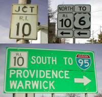
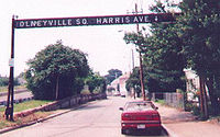 The junction and merge with U.S. Route 6 at Olneyville is part of the Olneyville Bypass, the first freeway in Rhode Island. In the space of about 1/4 mile (1/2 km), Route 10 interchanges with US 6, Westminster Street and Harris Avenue. (None of these except US 6 provide access to or from the north on Route 10.) The interchange with US 6 - a freeway - is partial, with no direct access from Route 10 north to US 6 west. Traffic making that movement must exit at Westminster Street and make several turns via Westminster Street, Barton Street, Broadway and Tobey Street, entering the combined Route 10 south/US 6 west on the right side from Tobey Street. There are current plans to rebuild this area of Route 10.
The combined Route 10 and US 6 - known as the Route 6-10 Connector - is the newest part of the Huntington Expressway. It heads northeast and east from Olneyville, interchanging with Dean Street (which provides access to Providence Place Mall). East of Dean Street, the freeway ends at a complicated interchange with Interstate 95. Route 10 ends there, while US 6 turns south with I-95 to reach Interstate 195. Access to downtown Providence is provided by ramps to the west end of Memorial Boulevard at Francis Street (U.S. Route 1).
 Despite the first section opening in 1953, the Route 10 designation was not used until 1966, when the freeway south of Route 2 (Reservoir Avenue) opened. The 1953 section was the Olneyville Bypass (also known as the Dennis J. Roberts Expressway, now also applied to U.S. Route 6 west of the bypass). Construction began in 1950 on the bypass of the congested Olneyville neighborhood, which the east–west U.S. Route 6 and Route 14 passed through (on Westminster Street, Hartford Avenue and Plainfield Street). The bypass ran from Hartford Avenue west of Olneyville around the south and east sides of Olneyville, junctioning with Plainfield Street, Huntington Avenue, Westminster Street and Broadway, and ending at Harris Avenue northeast of Olneyville.
Once the bypass opened in 1953, it carried US 6. Eastbound US 6 exited at Westminster Street to follow its old alignment towards downtown, but westbound US 6 was completely rerouted between downtown and Olneyville, following Kinsley Avenue, Eagle Street and Harris Avenue to reach the Olneyville Bypass.
The next section, from Olneyville south to Reservoir Avenue in Cranston, was built partially along the existing Huntington Avenue, and opened in 1960. It ended at a temporary trumpet interchange with Reservoir Avenue, which at the time carried both Route 2 and Route 3. (Route 3 has since been truncated to its intersection with Route 2 in West Warwick.) Route 2 was rerouted onto the new Huntington Expressway to end at US 6 at Olneyville, while Route 3 continued to run to U.S. Route 1 in Providence.
 The rest of the early Huntington Expressway, from Route 2 southeast across Interstate 95 and U.S. Route 1 to Route 12, was completed in 1966. It was then that the Route 10 designation was applied, and Route 2 was moved back to its present alignment. However, Route 10 did not end at Olneyville - it continued to the end of the bypass at Harris Avenue, and then took Harris Avenue, Eagle Street, Valley Street, River Avenue, Oneil Street, Veazie Street and Branch Avenue to end at Route 146.
The Route 12 interchange was not the planned end of the freeway; it was to continue roughly parallel to Route 117 and Route 117A, meeting Route 37 and ending near the south end of Route 117A.
.svg.png) For a time, Interstate 84 was planned to enter Providence via Olneyville. One plan by the state designated the Huntington Expressway south of Olneyville as Interstate 184, but this was rejected by the Federal Highway Administration
For a time, Interstate 84 was planned to enter Providence via Olneyville. One plan by the state designated the Huntington Expressway south of Olneyville as Interstate 184, but this was rejected by the Federal Highway Administration
.
The first section of the Route 6-10 Connector, from the east end of the Olneyville Bypass to Dean Street, opened in 1972. At that time, Route 10 was removed from its former surface alignment to a temporary end at Dean Street. The ramp it had taken northbound to Harris Avenue was cut by the new construction; the abutments for the bridge over the Northeast Corridor
and northbound Harris Avenue are still in place. U.S. Route 6 westbound was not moved, continuing to enter the Olneyville Bypass from Harris Avenue. A new ramp from Tobey Street to the bypass was added, replacing a removed left entrance from Broadway. The ramp from US 6 east to Westminster Street was also closed around this time, leaving its ramp to Broadway.
The other part of the Connector opened in 1988, connecting the Huntington Expressway and Olneyville Bypass to Interstate 95 in downtown Providence. US 6 was rerouted along the Connector and I-95 to reach Interstate 195. The ramps to downtown, connecting to Memorial Boulevard, did not open until 1993, as part of the redevelopment of downtown.
numbered exits between the southern terminus and the interchange with U.S. Route 6 in late 2010. The entire route is located in Providence County
.
State highway
State highway, state road or state route can refer to one of three related concepts, two of them related to a state or provincial government in a country that is divided into states or provinces :#A...
connector
Connector (road)
A connector is a highway or freeway road that connects to another highway or freeway. It can be part of an interchange such as the MacArthur Maze or a longer roadway such as the 13 mi Interstate 635 ....
in the U.S. state
U.S. state
A U.S. state is any one of the 50 federated states of the United States of America that share sovereignty with the federal government. Because of this shared sovereignty, an American is a citizen both of the federal entity and of his or her state of domicile. Four states use the official title of...
of Rhode Island
Rhode Island
The state of Rhode Island and Providence Plantations, more commonly referred to as Rhode Island , is a state in the New England region of the United States. It is the smallest U.S. state by area...
, running along the Huntington Expressway, the first freeway in the state. It connects Route 12 (Park Avenue) on the Cranston-Providence border with Interstate 95, U.S. Route 6 and Memorial Boulevard in downtown Providence, passing just east of the Olneyville area of Providence. It provides an alternate route to I-95 south of downtown, and connects it with the US 6 freeway west from Olneyville towards Interstate 295 and Connecticut
Connecticut
Connecticut is a state in the New England region of the northeastern United States. It is bordered by Rhode Island to the east, Massachusetts to the north, and the state of New York to the west and the south .Connecticut is named for the Connecticut River, the major U.S. river that approximately...
.
Route description
Interchange (road)
In the field of road transport, an interchange is a road junction that typically uses grade separation, and one or more ramps, to permit traffic on at least one highway to pass through the junction without directly crossing any other traffic stream. It differs from a standard intersection, at which...
with Route 12 (Park Avenue) on the Cranston-Providence border. The bridge that carries Route 12 over Route 10 has enough space for a four-lane freeway underneath, but only the ramp from Route 12 east to Route 10 north passes under it. Until around 2000, the ramp from Route 10 south to Route 12 east instead passed under the bridge; that movement is now made with a left turn onto Route 12. There were once plans to extend Route 10 south, in conjunction with an eastern extension of the Route 37 freeway.
Route 10 heads north through Providence, turning west before crossing U.S. Route 1 (Elmwood Avenue) at a partial interchange. There is no ramp to Route 10 south, and traffic exiting from Route 10 north must turn north on US 1. After crossing US 1, Route 10 crosses over Amtrak
Amtrak
The National Railroad Passenger Corporation, doing business as Amtrak , is a government-owned corporation that was organized on May 1, 1971, to provide intercity passenger train service in the United States. "Amtrak" is a portmanteau of the words "America" and "track". It is headquartered at Union...
's Northeast Corridor
Northeast Corridor
The Northeast Corridor is a fully electrified railway line owned primarily by Amtrak serving the Northeast megalopolis of the United States from Boston in the north, via New York to Washington, D.C. in the south, with branches serving other cities...
and enters Cranston.
Route 10 crosses Interstate 95 at a full interchange, sometimes known as the "Friendly Interchange" for the community of Quakers it partially destroyed. It then heads northwest, crossing under Pontiac Avenue and then junctioning Route 2 (Reservoir Avenue) just after crossing back into Providence. After the Route 2 interchange, Route 10 again crosses back into Cranston, running west of the parallel Niantic Avenue, which is on the city line. The final crossing, back into Providence, is just after the Cranston Street interchange, where Niantic Avenue ends.
Upon crossing into Providence, Route 10 passes over and begins to parallel the Northeast Corridor
Northeast Corridor
The Northeast Corridor is a fully electrified railway line owned primarily by Amtrak serving the Northeast megalopolis of the United States from Boston in the north, via New York to Washington, D.C. in the south, with branches serving other cities...
, and interchanges with Huntington Avenue. From that interchange north to Olneyville, Huntington Avenue was upgraded on the spot to become the Huntington Expressway - hence the name. A single interchange - with Union Avenue - lies along that stretch.
The combined Route 10 and US 6 - known as the Route 6-10 Connector - is the newest part of the Huntington Expressway. It heads northeast and east from Olneyville, interchanging with Dean Street (which provides access to Providence Place Mall). East of Dean Street, the freeway ends at a complicated interchange with Interstate 95. Route 10 ends there, while US 6 turns south with I-95 to reach Interstate 195. Access to downtown Providence is provided by ramps to the west end of Memorial Boulevard at Francis Street (U.S. Route 1).
History
Once the bypass opened in 1953, it carried US 6. Eastbound US 6 exited at Westminster Street to follow its old alignment towards downtown, but westbound US 6 was completely rerouted between downtown and Olneyville, following Kinsley Avenue, Eagle Street and Harris Avenue to reach the Olneyville Bypass.
The next section, from Olneyville south to Reservoir Avenue in Cranston, was built partially along the existing Huntington Avenue, and opened in 1960. It ended at a temporary trumpet interchange with Reservoir Avenue, which at the time carried both Route 2 and Route 3. (Route 3 has since been truncated to its intersection with Route 2 in West Warwick.) Route 2 was rerouted onto the new Huntington Expressway to end at US 6 at Olneyville, while Route 3 continued to run to U.S. Route 1 in Providence.
The Route 12 interchange was not the planned end of the freeway; it was to continue roughly parallel to Route 117 and Route 117A, meeting Route 37 and ending near the south end of Route 117A.
Federal Highway Administration
The Federal Highway Administration is a division of the United States Department of Transportation that specializes in highway transportation. The agency's major activities are grouped into two "programs," the Federal-aid Highway Program and the Federal Lands Highway Program...
.
The first section of the Route 6-10 Connector, from the east end of the Olneyville Bypass to Dean Street, opened in 1972. At that time, Route 10 was removed from its former surface alignment to a temporary end at Dean Street. The ramp it had taken northbound to Harris Avenue was cut by the new construction; the abutments for the bridge over the Northeast Corridor
Northeast Corridor
The Northeast Corridor is a fully electrified railway line owned primarily by Amtrak serving the Northeast megalopolis of the United States from Boston in the north, via New York to Washington, D.C. in the south, with branches serving other cities...
and northbound Harris Avenue are still in place. U.S. Route 6 westbound was not moved, continuing to enter the Olneyville Bypass from Harris Avenue. A new ramp from Tobey Street to the bypass was added, replacing a removed left entrance from Broadway. The ramp from US 6 east to Westminster Street was also closed around this time, leaving its ramp to Broadway.
The other part of the Connector opened in 1988, connecting the Huntington Expressway and Olneyville Bypass to Interstate 95 in downtown Providence. US 6 was rerouted along the Connector and I-95 to reach Interstate 195. The ramps to downtown, connecting to Memorial Boulevard, did not open until 1993, as part of the redevelopment of downtown.
Exit list
The exits of Route 10 were previously unnumbered, but RIDOTRhode Island Department of Transportation
The Rhode Island Department of Transportation is a Rhode Island state government agency charged with construction, maintenance and inspection of a wide range of transportation infrastructure. These include 1,102 miles of state roads and highways, 772 bridges, and 777 traffic signals...
numbered exits between the southern terminus and the interchange with U.S. Route 6 in late 2010. The entire route is located in Providence County
Providence County, Rhode Island
-Demographics:As of the census of 2000, there were 621,602 people, 239,936 households, and 152,839 families residing in the county. The population density was 1,504 people per square mile . There were 253,214 housing units at an average density of 613 per square mile...
.
| Municipality | Mile | # Exit number An exit number is a number assigned to a road junction, usually an exit from a freeway. It is usually marked on the same sign as the destinations of the exit, as well as a sign in the gore.... |
Destinations | Notes |
|---|---|---|---|---|
| Providence Providence, Rhode Island Providence is the capital and most populous city of Rhode Island and was one of the first cities established in the United States. Located in Providence County, it is the third largest city in the New England region... |
0.0 | , Warwick Avenue | Southbound exit and northbound entrance | |
| 0.5 | 1 | No southbound entrance; no access from Route 10 north to US 1 south | ||
| Cranston Cranston, Rhode Island Cranston, once known as Pawtuxet, is a city in Providence County, Rhode Island, United States. With a population of 80,387 at the 2010 census, it is the third largest city in the state. The center of population of Rhode Island is located in Cranston... |
0.8 | 2 | Signed as exits 2A (north) and 2B (south) | |
| Providence Providence, Rhode Island Providence is the capital and most populous city of Rhode Island and was one of the first cities established in the United States. Located in Providence County, it is the third largest city in the New England region... |
1.4 | 3 | , Pontiac Avenue | Signed as exits 3A (north) and 3B (south) southbound |
| Cranston Cranston, Rhode Island Cranston, once known as Pawtuxet, is a city in Providence County, Rhode Island, United States. With a population of 80,387 at the 2010 census, it is the third largest city in the state. The center of population of Rhode Island is located in Cranston... |
2.7 | 4 | Niantic Avenue, Garfield Avenue, Cranston Street | |
| Providence Providence, Rhode Island Providence is the capital and most populous city of Rhode Island and was one of the first cities established in the United States. Located in Providence County, it is the third largest city in the New England region... |
3.1 | 5 | Union Avenue, Huntington Avenue | |
| 3.5 | (6) | , Hartford, CT Hartford, Connecticut Hartford is the capital of the U.S. state of Connecticut. The seat of Hartford County until Connecticut disbanded county government in 1960, it is the second most populous city on New England's largest river, the Connecticut River. As of the 2010 Census, Hartford's population was 124,775, making... |
Exit not numbered; no northbound exit; US 6 joins northbound and exits southbound | |
| 3.6 | 7 | Westminster Street, Olneyville | Northbound exit and southbound entrance | |
| 4.6 | 22C | Dean Street, Atwells Avenue, Providence Place Providence Place Providence Place is an urban shopping mall in the central part of Providence, Rhode Island. Opened on August 20, 1999, it is located near the Rhode Island State House and Providence Station. It compromises three main floors and is connected to the nearby Westin Hotel via skyway. It also features... |
Exit numbering continued from I-95 south on southbound ramp only; exit unnumbered on northbound Route 10 | |
| 5.0 | Memorial Boulevard, Downtown Providence Providence, Rhode Island Providence is the capital and most populous city of Rhode Island and was one of the first cities established in the United States. Located in Providence County, it is the third largest city in the New England region... |
Northbound exit and southbound entrance | ||
| 5.0 | – New York New York City New York is the most populous city in the United States and the center of the New York Metropolitan Area, one of the most populous metropolitan areas in the world. New York exerts a significant impact upon global commerce, finance, media, art, fashion, research, technology, education, and... , Boston Boston Boston is the capital of and largest city in Massachusetts, and is one of the oldest cities in the United States. The largest city in New England, Boston is regarded as the unofficial "Capital of New England" for its economic and cultural impact on the entire New England region. The city proper had... |
Northbound exit and southbound entrance |