
.gif)
Route 103 (Rhode Island)
Encyclopedia
Route 103 is a numbered State Highway running 11.3 miles (18.2 km) in Rhode Island
. It runs from I-195 in East Providence
to the Massachusetts
state line in the town of Warren
, where the road continues as Massachusetts Route 103
. Route 103 is a major commercial corridor in East Providence
.
. Route 103 turns south with Route 114 along Pawtucket Avenue, with Route 114 soon separating. Route 103 continues south then veers to the southeast along Willett Avenue as it heads towards the town of Barrington
. In Barrington, it continues east as County Road, then meets with and overlaps Route 114 for a second time as the routes cross the Barrington and Palmer
rivers into the town of Warren
. Route 103 separates from Route 114 along Child Street as it continues east towards the Massachusetts state line, where the road continues as Massachusetts Route 103
.
 Route 103 was an original route assigned in 1923. It used to be much longer, extending 38 miles (61.2 km) through Providence and along present-day Route 14
to Connecticut
, where it used to continue as Route 103. In 1932, Connecticut renumbered its 1920s Route 103 to Route 14. Rhode Island renumbered the portion of Route 103 west of Providence to match the new Connecticut route number.
At one time, the main road east from Providence (at first NE 3, now US 6) used Route 103 rather than the current US 6 alignment. Maps disagree on when the change to the current alignment took place. However, rather than using Warren Avenue to the Washington Bridge
, the main road continued north on Pawtucket Avenue to Waterman Avenue, and used Waterman Avenue over the old Red Bridge to Providence. When the main road was moved to current US 6, it at first continued to use Waterman Avenue via MA 114A and County Street to the state line.
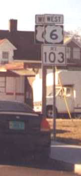
The current alignment of Route 103 along Warren Avenue in East Providence
was also US 6 before Interstate 195 was built. Some signs still mark it as US 6, including some signs placed since 2000.
Rhode Island
The state of Rhode Island and Providence Plantations, more commonly referred to as Rhode Island , is a state in the New England region of the United States. It is the smallest U.S. state by area...
. It runs from I-195 in East Providence
East Providence, Rhode Island
East Providence is a city in Providence County, Rhode Island, United States. The population was 47,037 at the 2010 census, making it the fifth largest city in the state.-Geography:East Providence is located at ....
to the Massachusetts
Massachusetts
The Commonwealth of Massachusetts is a state in the New England region of the northeastern United States of America. It is bordered by Rhode Island and Connecticut to the south, New York to the west, and Vermont and New Hampshire to the north; at its east lies the Atlantic Ocean. As of the 2010...
state line in the town of Warren
Warren, Rhode Island
Warren is a town in Bristol County, Rhode Island, United States. The population was 10,611 at the 2010 census.-History:Warren was the site of the Indian village of Sowams on the peninsula called Pokanoket , and was first explored by Europeans in 1621, by Edward Winslow and Stephen Hopkins...
, where the road continues as Massachusetts Route 103
Massachusetts Route 103
-Route description:Massachusetts Route 103 is a continuation of R.I. Route 103. It begins in Swansea at the Warren line, heading eastward as Wilbur Avenue. It crosses the Cole River before entering the village of Ocean Grove. As the route enters Somerset it crosses the Lees River, just east of...
. Route 103 is a major commercial corridor in East Providence
East Providence, Rhode Island
East Providence is a city in Providence County, Rhode Island, United States. The population was 47,037 at the 2010 census, making it the fifth largest city in the state.-Geography:East Providence is located at ....
.
Route description
Route 103 begins at the eastbound Exit 5 off-ramp of I-195 in East Providence, running along Warren Avenue until the intersection with Route 114Route 114 (Rhode Island)
Route 114 is a numbered State Highway running in the U.S. state of Rhode Island. It connects the city of Newport to the city of Woonsocket. Route 114 was a major north–south artery for its entire length until the arrival of the Interstate Highway System...
. Route 103 turns south with Route 114 along Pawtucket Avenue, with Route 114 soon separating. Route 103 continues south then veers to the southeast along Willett Avenue as it heads towards the town of Barrington
Barrington, Rhode Island
Barrington is a town in Bristol County, Rhode Island, United States. The population was 16,310 at the 2010 census.In July 2005, CNN/Money and Money magazine ranked Barrington sixth on its list of the 100 best places to live in the United States.-History:...
. In Barrington, it continues east as County Road, then meets with and overlaps Route 114 for a second time as the routes cross the Barrington and Palmer
Palmer River
The Palmer River is a river southwest of Cooktown in northeastern Australia. It was the site of a gold rush in the late 19th century which started in 1872. The Palmer River flows west across Cape York to the Gulf of Carpentaria, via the Mitchell River...
rivers into the town of Warren
Warren, Rhode Island
Warren is a town in Bristol County, Rhode Island, United States. The population was 10,611 at the 2010 census.-History:Warren was the site of the Indian village of Sowams on the peninsula called Pokanoket , and was first explored by Europeans in 1621, by Edward Winslow and Stephen Hopkins...
. Route 103 separates from Route 114 along Child Street as it continues east towards the Massachusetts state line, where the road continues as Massachusetts Route 103
Massachusetts Route 103
-Route description:Massachusetts Route 103 is a continuation of R.I. Route 103. It begins in Swansea at the Warren line, heading eastward as Wilbur Avenue. It crosses the Cole River before entering the village of Ocean Grove. As the route enters Somerset it crosses the Lees River, just east of...
.
History
Route 14 (Rhode Island)
Route 14 is a numbered State Highway running in the U.S. State of Rhode Island.-Route:Route 14 takes the following route through the State:*Coventry: ; Connecticut State line at CT 14/CT 14A to Foster town line**Plainfield Pike...
to Connecticut
Connecticut
Connecticut is a state in the New England region of the northeastern United States. It is bordered by Rhode Island to the east, Massachusetts to the north, and the state of New York to the west and the south .Connecticut is named for the Connecticut River, the major U.S. river that approximately...
, where it used to continue as Route 103. In 1932, Connecticut renumbered its 1920s Route 103 to Route 14. Rhode Island renumbered the portion of Route 103 west of Providence to match the new Connecticut route number.
At one time, the main road east from Providence (at first NE 3, now US 6) used Route 103 rather than the current US 6 alignment. Maps disagree on when the change to the current alignment took place. However, rather than using Warren Avenue to the Washington Bridge
Washington Bridge (Providence)
The Washington Bridge is a paired bridge carrying Interstate 195 over the Seekonk River from Providence to East Providence, Rhode Island.- History :...
, the main road continued north on Pawtucket Avenue to Waterman Avenue, and used Waterman Avenue over the old Red Bridge to Providence. When the main road was moved to current US 6, it at first continued to use Waterman Avenue via MA 114A and County Street to the state line.
The current alignment of Route 103 along Warren Avenue in East Providence
East Providence, Rhode Island
East Providence is a city in Providence County, Rhode Island, United States. The population was 47,037 at the 2010 census, making it the fifth largest city in the state.-Geography:East Providence is located at ....
was also US 6 before Interstate 195 was built. Some signs still mark it as US 6, including some signs placed since 2000.