
Rothley, Northumberland
Encyclopedia
Rothley is a small settlement in Northumberland
, England
about 2 miles (3 km) north east of Cambo
and about 6 miles (10 km) west of Morpeth
.
constituency of Berwick-upon-Tweed
.
Rothley Crags , a wild tract of country which was once Sir William Blackett's deer-park. With the mania our ancestors had for ruins, and surely there were enough in Northumberland already without building them, Sir William had some most realistic castellated ruins built on the top of the crags!
Rothley Lake breaks the bareness of the scenery, prettily bordered with trees and overlooked by a wall of rugged crags topped by Codger Fort , erected by Sir Walter Blackett after the Jacobite rising of 1745, probably to demonstrate his loyalty. The fort contained six cannon and hence would have proved a serious obstacle to any invading forces. Huge beeches and pines line the ascending road from the lake.
Northumberland
Northumberland is the northernmost ceremonial county and a unitary district in North East England. For Eurostat purposes Northumberland is a NUTS 3 region and is one of three boroughs or unitary districts that comprise the "Northumberland and Tyne and Wear" NUTS 2 region...
, England
England
England is a country that is part of the United Kingdom. It shares land borders with Scotland to the north and Wales to the west; the Irish Sea is to the north west, the Celtic Sea to the south west, with the North Sea to the east and the English Channel to the south separating it from continental...
about 2 miles (3 km) north east of Cambo
Cambo
Cambo is a village in Northumberland, England. It is about to the west of the county town of Morpeth at the junction of the B6342 and B6343 roads...
and about 6 miles (10 km) west of Morpeth
Morpeth, Northumberland
Morpeth is the county town of Northumberland, England. It is situated on the River Wansbeck which flows east through the town. The town is from the A1, which bypasses it. Since 1981, it has been the administrative centre of the County of Northumberland. In the 2001 census the town had a population...
.
Governance
Rothley, Northumberland is in the parliamentaryBritish House of Commons
The House of Commons is the lower house of the Parliament of the United Kingdom, which also comprises the Sovereign and the House of Lords . Both Commons and Lords meet in the Palace of Westminster. The Commons is a democratically elected body, consisting of 650 members , who are known as Members...
constituency of Berwick-upon-Tweed
Berwick-upon-Tweed (UK Parliament constituency)
Berwick-upon-Tweed is a constituency represented in the House of Commons of the Parliament of the United Kingdom. It elects one Member of Parliament by the first past the post system of election.-Boundaries:...
.
Landmarks
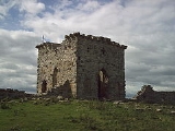
Rothley Castle is an 18th-century gothic folly built to resemble a medieval castle, situated at Rothley. It was designed in 1755 by architect Daniel Garrett for Sir Walter Blackett, owner of Wallington Hall, from where it is visible on the hillside.Rothley Crags , a wild tract of country which was once Sir William Blackett's deer-park. With the mania our ancestors had for ruins, and surely there were enough in Northumberland already without building them, Sir William had some most realistic castellated ruins built on the top of the crags!
Rothley Lake breaks the bareness of the scenery, prettily bordered with trees and overlooked by a wall of rugged crags topped by Codger Fort , erected by Sir Walter Blackett after the Jacobite rising of 1745, probably to demonstrate his loyalty. The fort contained six cannon and hence would have proved a serious obstacle to any invading forces. Huge beeches and pines line the ascending road from the lake.