
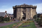
Morpeth, Northumberland
Overview
County town
A county town is a county's administrative centre in the United Kingdom or Ireland. County towns are usually the location of administrative or judicial functions, or established over time as the de facto main town of a county. The concept of a county town eventually became detached from its...
of Northumberland
Northumberland
Northumberland is the northernmost ceremonial county and a unitary district in North East England. For Eurostat purposes Northumberland is a NUTS 3 region and is one of three boroughs or unitary districts that comprise the "Northumberland and Tyne and Wear" NUTS 2 region...
, England
England
England is a country that is part of the United Kingdom. It shares land borders with Scotland to the north and Wales to the west; the Irish Sea is to the north west, the Celtic Sea to the south west, with the North Sea to the east and the English Channel to the south separating it from continental...
. It is situated on the River Wansbeck
River Wansbeck
The River Wansbeck runs through the county of Northumberland, England. It rises above Sweethope Lough on the edge of Forelaws Forest in the area known locally as The Wanneys ; runs through the town of Ashington before discharging into the North Sea at Sandy Bay near Newbiggin-by-the-Sea.The River...
which flows east through the town. The town is 1.25 miles (2 km) from the A1, which bypasses it. Since 1981, it has been the administrative centre of the County of Northumberland. In the 2001 census the town had a population of 13,833. Nearby villages include Mitford and Pegswood
Pegswood
Pegswood is a mining village in Northumberland, England, and the site of the former Pegswood colliery. Pegswood is two miles east of Morpeth and three miles west of Ashington, with a population of around 3260. Pegswood is on a small hill above the valley in which Morpeth is situated, close to the...
.
Morpeth grew up at an important crossing point of the River Wansbeck.