
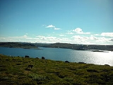
Rosskreppfjorden
Encyclopedia
Lake
A lake is a body of relatively still fresh or salt water of considerable size, localized in a basin, that is surrounded by land. Lakes are inland and not part of the ocean and therefore are distinct from lagoons, and are larger and deeper than ponds. Lakes can be contrasted with rivers or streams,...
on the border between the municipalities of Valle (in Aust-Agder
Aust-Agder
is a county in Norway, bordering Telemark, Rogaland, and Vest-Agder. In 2002, there were 102,945 inhabitants, which is 2.2% of the total population in Norway. Its area is . The administrative center of the county is in Arendal....
county) and Sirdal
Sirdal
Sirdal is a municipality in Vest-Agder county, Norway. Sirdal was separated from Bakke in 1849. Sirdal was divided into Tonstad and Øvre Sirdal on 1 January 1905, but these were again merged to recreate Sirdal on 1 January 1960....
(in Vest-Agder
Vest-Agder
In the 16th century, Dutch merchant vessels began to visit ports in southern Norway to purchase salmon and other goods. Soon thereafter the export of timber began, as oak from southern Norway was exceptionally well suited for shipbuilding...
county), Norway
Norway
Norway , officially the Kingdom of Norway, is a Nordic unitary constitutional monarchy whose territory comprises the western portion of the Scandinavian Peninsula, Jan Mayen, and the Arctic archipelago of Svalbard and Bouvet Island. Norway has a total area of and a population of about 4.9 million...
. The lake is part of the Kvina river system and has a hydroelectric
Hydroelectricity
Hydroelectricity is the term referring to electricity generated by hydropower; the production of electrical power through the use of the gravitational force of falling or flowing water. It is the most widely used form of renewable energy...
power plant in a dam
Dam
A dam is a barrier that impounds water or underground streams. Dams generally serve the primary purpose of retaining water, while other structures such as floodgates or levees are used to manage or prevent water flow into specific land regions. Hydropower and pumped-storage hydroelectricity are...
on the south end of the lake. The lake has an area of 29.51 square kilometres (11.4 sq mi) and sits at an elevation of about 929 to 890 m (3,047.9 to 2,919.9 ) above sea level.
The lake flows south into the Øyarvatnet
Øyarvatnet
Øyarvatnet or Øyarvatn is a lake in the municipality of Valle in Aust-Agder county and Sirdal in Vest-Agder county, Norway. It is part of the Kvina river system. It is located just to the south of the lake Rosskreppfjorden. The lake has an area of and sits at an elevation of ....
lake. Rosskreppfjorden is located about 21 kilometres (13 mi) southwest of the village of Valle. The lakes Kolsvatnet
Kolsvatnet
Kolsvatnet is a lake in the municipality of Valle in Aust-Agder county, Norway. It is located about southwest of the village of Valle. The lake is located south of the lake Botnsvatnet, east of the mountain Urddalsknuten, and northeast of the lake Rosskreppfjorden. The lake has an area of and...
and Botnsvatnet
Botnsvatnet
Botnsvatnet or Botsvatnet is a lake in the municipality of Valle in Aust-Agder county, Norway. The lake is located just north of the lakes Rosskreppfjorden and Kolsvatnet and also to the north of the mountain Urddalsknuten. The village of Valle is located to the east of the lake. The lake has...
are located just to the northeast of Rosskreppfjorden, and the mountain Urddalsknuten
Urddalsknuten
Urddalsknuten or Urdalsknuten is a mountain that lies on the border of the municipalities Sirdal in Vest-Agder county and Valle in Aust-Agder county, Norway. The mountain is located in the Setesdalsheiene mountain range, and at , it is the highest mountain in Vest-Agder county...
is just to the north of the lake.