

Rocky River (New South Wales)
Encyclopedia
.jpg)
New South Wales
New South Wales is a state of :Australia, located in the east of the country. It is bordered by Queensland, Victoria and South Australia to the north, south and west respectively. To the east, the state is bordered by the Tasman Sea, which forms part of the Pacific Ocean. New South Wales...
, Australia
Australia
Australia , officially the Commonwealth of Australia, is a country in the Southern Hemisphere comprising the mainland of the Australian continent, the island of Tasmania, and numerous smaller islands in the Indian and Pacific Oceans. It is the world's sixth-largest country by total area...
near the town of Uralla
Uralla, New South Wales
Uralla is a small town and on the Northern Tablelands, New South Wales, Australia. The town is located at the intersection of the New England Highway and Thunderbolts Way 465 kilometres north of Sydney and about 23 kilometres south west of the city of Armidale...
on the Northern Tablelands
Northern Tablelands, New South Wales
The Northern Tablelands, also known as the New England Tableland, is a plateau and a region of the Great Dividing Range in northern New South Wales, Australia. It includes the New England Range, the narrow highlands area of the New England region, stretching from the Moonbi Range in the south to...
plateau.
About two kilometres west of Uralla, was the gold
Gold
Gold is a chemical element with the symbol Au and an atomic number of 79. Gold is a dense, soft, shiny, malleable and ductile metal. Pure gold has a bright yellow color and luster traditionally considered attractive, which it maintains without oxidizing in air or water. Chemically, gold is a...
mining area and associated village also called Rocky River. In 1851 W.F. Buchanan and J. Lucas reported to the Maitland office that gold had been found at Rocky River. This announcement was made official on 7 October 1851, by Commissioner Massie, and started a rush to the area. In 1852 the first licenses to prospect were taken out. During October 1852, the Windeyer Brothers discovered the first payable gold on the field washing about five ounces of gold in less than a week. This caused further interest and by the end of 1852 the goldfield's population rose to around 150 persons. At this time it was all alluvial mining, confined to the rivers and creeks. Panning and cradling were the usual methods of extracting the gold from the washdirt.
The census carried out between the 3 and 5 June 1854 reported that there were 86 tents on the field and a population of 350, comprising 193 males, 58 females and 99 children. Until 1856 Rocky River gold field was small and of comparatively no importance to the remainder of the country. In February 1856 John Jones discovered a few specks of gold lying in cartwheel tracks on what is now known as Mt Jones. Jones's discovery then led to the sinking of deep-lead shafts in the vicinity and another rush into the area.
Around 1856 Rocky River was a thriving gold field town with an estimated 4,000 to 5,000 miners and their families. Rocky River, at its peak supported 20 hotels, numerous boarding houses, stores, churches and schools. Among the miners were many Chinese, some of whom had made the long trek from Goulburn
Goulburn, New South Wales
Goulburn is a provincial city in the Southern Tablelands of New South Wales, Australia in Goulburn Mulwaree Council Local Government Area. It is located south-west of Sydney on the Hume Highway and above sea-level. On Census night 2006, Goulburn had a population of 20,127 people...
and Victorian goldfields. Many of the Chinese miners worked over the original alluvial field at Maitland Point, south of Thunderbolts Way
Thunderbolts Way
Thunderbolts Way is a New South Wales country road linking Gloucester to Walcha , Uralla, where it very briefly joins the New England Highway and, to Copes Creek, south of the Gwydir Highway intersection at Inverell...
, near Rocky River bridge. Some of these miners later bought land around the Northern Tablelands
Northern Tablelands, New South Wales
The Northern Tablelands, also known as the New England Tableland, is a plateau and a region of the Great Dividing Range in northern New South Wales, Australia. It includes the New England Range, the narrow highlands area of the New England region, stretching from the Moonbi Range in the south to...
and settled there as farmers. After the rush, permanent allotments were taken up and in 1861.
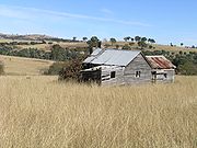
Today only the Public School on Thunderbolts Way and a few houses remain.
In the 2006 Census (held on 8th August 2006), there were 479 persons usually resident in the Rocky River area.