
Rockingham, Vermont
Encyclopedia
Rockingham is a town
in Windham County
, Vermont
, United States
, along the Connecticut River
. The population was 5,309 at the 2000 census. Rockingham includes the incorporated villages of Bellows Falls
and Saxtons River
, as well as a large rural area west of Interstate 91
.
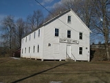
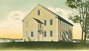
Rockingham has no formal town center, instead town offices and the Rockingham Public Library are located in the village of Bellows Falls. The listed center of town is on Route 103, a popular east-west route across the state, the location of the Rockingham Meeting House.
 One of the New Hampshire grants
, it was chartered by Governor Benning Wentworth
on December 28, 1752 and named for Lord Rockingham
. The township was granted to Samuel Johnson and 72 others. First settled in 1753, pioneer
s fished for salmon
and shad
. By 1771, the population reached 225. In 1785, Colonel Enoch Hale
erected the first bridge over the Connecticut River
, and until 1796, it remained the only bridge across. The village of Bellows Falls became an important mill town
.
, the town has a total area of 42.3 square miles (109.6 km2), of which 41.9 square miles (108.5 km2) is land and 0.4 square mile (1.1 km2) (0.97%) is water. Drained by the Williams River
, Rockingham is bounded on the east by the Connecticut River
.
It is crossed by Interstate 91
, U.S. Route 5
, Vermont Route 103
and Vermont Route 121.
of 2000, there were 5,309 people, 2,202 households, and 1,387 families residing in the town. The population density
was 126.7 people per square mile (48.9/km2). There were 2,425 housing units at an average density of 57.9 per square mile (22.3/km2). The racial makeup of the town was 97.38% White, 0.34% African American, 0.09% Native American, 0.55% Asian, 0.06% Pacific Islander, 0.26% from other races
, and 1.32% from two or more races. Hispanic or Latino of any race were 1.15% of the population.
There were 2,202 households out of which 31.1% had children under the age of 18 living with them, 47.2% were couples living together and joined in either marriage
or civil union
, 12.0% had a female householder with no husband present, and 37.0% were non-families. 30.1% of all households were made up of individuals and 13.4% had someone living alone who was 65 years of age or older. The average household size was 2.39 and the average family size was 2.96.
In the town the population was spread out with 25.1% under the age of 18, 6.8% from 18 to 24, 27.1% from 25 to 44, 25.5% from 45 to 64, and 15.4% who were 65 years of age or older. The median age was 39 years. For every 100 females there were 93.8 males. For every 100 females age 18 and over, there were 88.6 males.
The median income for a household in the town was $33,423, and the median income for a family was $45,503. Males had a median income of $29,200 versus $22,944 for females. The per capita income
for the town was $19,051. About 4.8% of families and 10.0% of the population were below the poverty line, including 13.5% of those under age 18 and 9.6% of those age 65 or over.
New England town
The New England town is the basic unit of local government in each of the six New England states. Without a direct counterpart in most other U.S. states, New England towns are conceptually similar to civil townships in other states, but are incorporated, possessing powers like cities in other...
in Windham County
Windham County, Vermont
Windham County is a county located in the U.S. state of Vermont. As of 2010, the population was 44,513. Its shire town is Newfane.-Geography:According to the U.S...
, Vermont
Vermont
Vermont is a state in the New England region of the northeastern United States of America. The state ranks 43rd in land area, , and 45th in total area. Its population according to the 2010 census, 630,337, is the second smallest in the country, larger only than Wyoming. It is the only New England...
, United States
United States
The United States of America is a federal constitutional republic comprising fifty states and a federal district...
, along the Connecticut River
Connecticut River
The Connecticut River is the largest and longest river in New England, and also an American Heritage River. It flows roughly south, starting from the Fourth Connecticut Lake in New Hampshire. After flowing through the remaining Connecticut Lakes and Lake Francis, it defines the border between the...
. The population was 5,309 at the 2000 census. Rockingham includes the incorporated villages of Bellows Falls
Bellows Falls, Vermont
Bellows Falls is an incorporated village located in the town of Rockingham in Windham County, Vermont, United States. The population was 3,165 at the 2000 census...
and Saxtons River
Saxtons River, Vermont
Saxtons River is an incorporated village in the town of Rockingham in Windham County, Vermont, United States. The population was 519 at the 2000 census. For over a hundred years, Saxtons River has been the home of Vermont Academy, an independent secondary school.The Saxtons River Village Historic...
, as well as a large rural area west of Interstate 91
Interstate 91
Interstate 91 is an Interstate Highway in the New England region of the United States. It provides the primary north–south thoroughfare in the western part of New England...
.
Rockingham has no formal town center, instead town offices and the Rockingham Public Library are located in the village of Bellows Falls. The listed center of town is on Route 103, a popular east-west route across the state, the location of the Rockingham Meeting House.
History
New Hampshire Grants
The New Hampshire Grants or Benning Wentworth Grants were land grants made between 1749 and 1764 by the provincial governor of New Hampshire, Benning Wentworth. The land grants, totaling about 135 , were made on land claimed by New Hampshire west of the Connecticut River, territory that was also...
, it was chartered by Governor Benning Wentworth
Benning Wentworth
Benning Wentworth was the colonial governor of New Hampshire from 1741 to 1766.-Biography:The eldest child of the John Wentworth who had been Lieutenant Governor, he was born and died in Portsmouth, New Hampshire. Wentworth graduated from Harvard College in 1715...
on December 28, 1752 and named for Lord Rockingham
Charles Watson-Wentworth, 2nd Marquess of Rockingham
Charles Watson-Wentworth, 2nd Marquess of Rockingham, KG, PC , styled The Hon. Charles Watson-Wentworth before 1733, Viscount Higham between 1733 and 1746, Earl of Malton between 1746 and 1750 and The Earl Malton in 1750, was a British Whig statesman, most notable for his two terms as Prime...
. The township was granted to Samuel Johnson and 72 others. First settled in 1753, pioneer
American pioneer
American pioneers are any of the people in American history who migrated west to join in settling and developing new areas. The term especially refers to those who were going to settle any territory which had previously not been settled or developed by European or American society, although the...
s fished for salmon
Salmon
Salmon is the common name for several species of fish in the family Salmonidae. Several other fish in the same family are called trout; the difference is often said to be that salmon migrate and trout are resident, but this distinction does not strictly hold true...
and shad
Shad
The shads or river herrings comprise the genus Alosa, fish related to herring in the family Clupeidae. They are distinct from others in that family by having a deeper body and spawning in rivers. The several species frequent different areas on both sides of the Atlantic Ocean, Mediterranean Sea....
. By 1771, the population reached 225. In 1785, Colonel Enoch Hale
Enoch Hale
Enoch Hale was born in Rowley, Massachusetts on November 28, 1733. He and his brother Nathan Hale would move to Rindge, New Hampshire as young men. During the French and Indian War Enoch Hale served in the New Hampshire Provincial Regiment in 1755 and 1757-1758...
erected the first bridge over the Connecticut River
Connecticut River
The Connecticut River is the largest and longest river in New England, and also an American Heritage River. It flows roughly south, starting from the Fourth Connecticut Lake in New Hampshire. After flowing through the remaining Connecticut Lakes and Lake Francis, it defines the border between the...
, and until 1796, it remained the only bridge across. The village of Bellows Falls became an important mill town
Mill town
A mill town, also known as factory town or mill village, is typically a settlement that developed around one or more mills or factories .- United Kingdom:...
.
Geography
According to the United States Census BureauUnited States Census Bureau
The United States Census Bureau is the government agency that is responsible for the United States Census. It also gathers other national demographic and economic data...
, the town has a total area of 42.3 square miles (109.6 km2), of which 41.9 square miles (108.5 km2) is land and 0.4 square mile (1.1 km2) (0.97%) is water. Drained by the Williams River
Williams River (Vermont)
The Williams River is a river in the U.S. state of Vermont. It is a tributary of the Connecticut River. Its watershed covers 117 square miles; land use is about 80% forested and 4% agricultural, and the upper river supports wild brook trout and brown trout ....
, Rockingham is bounded on the east by the Connecticut River
Connecticut River
The Connecticut River is the largest and longest river in New England, and also an American Heritage River. It flows roughly south, starting from the Fourth Connecticut Lake in New Hampshire. After flowing through the remaining Connecticut Lakes and Lake Francis, it defines the border between the...
.
It is crossed by Interstate 91
Interstate 91
Interstate 91 is an Interstate Highway in the New England region of the United States. It provides the primary north–south thoroughfare in the western part of New England...
, U.S. Route 5
U.S. Route 5
U.S. Route 5 is a north–south United States highway running through the New England states of Connecticut, Massachusetts, and Vermont. Significant cities along the route include New Haven, Connecticut; Hartford, Connecticut; and Springfield, Massachusetts. From Hartford northward to St...
, Vermont Route 103
Vermont Route 103
Vermont Route 103 is a north–south state highway in southern Vermont, United States. It runs from Rockingham in the east to Clarendon near Rutland in the west...
and Vermont Route 121.
Demographics
As of the censusCensus
A census is the procedure of systematically acquiring and recording information about the members of a given population. It is a regularly occurring and official count of a particular population. The term is used mostly in connection with national population and housing censuses; other common...
of 2000, there were 5,309 people, 2,202 households, and 1,387 families residing in the town. The population density
Population density
Population density is a measurement of population per unit area or unit volume. It is frequently applied to living organisms, and particularly to humans...
was 126.7 people per square mile (48.9/km2). There were 2,425 housing units at an average density of 57.9 per square mile (22.3/km2). The racial makeup of the town was 97.38% White, 0.34% African American, 0.09% Native American, 0.55% Asian, 0.06% Pacific Islander, 0.26% from other races
Race (United States Census)
Race and ethnicity in the United States Census, as defined by the Federal Office of Management and Budget and the United States Census Bureau, are self-identification data items in which residents choose the race or races with which they most closely identify, and indicate whether or not they are...
, and 1.32% from two or more races. Hispanic or Latino of any race were 1.15% of the population.
There were 2,202 households out of which 31.1% had children under the age of 18 living with them, 47.2% were couples living together and joined in either marriage
Marriage
Marriage is a social union or legal contract between people that creates kinship. It is an institution in which interpersonal relationships, usually intimate and sexual, are acknowledged in a variety of ways, depending on the culture or subculture in which it is found...
or civil union
Civil union
A civil union, also referred to as a civil partnership, is a legally recognized form of partnership similar to marriage. Beginning with Denmark in 1989, civil unions under one name or another have been established by law in many developed countries in order to provide same-sex couples rights,...
, 12.0% had a female householder with no husband present, and 37.0% were non-families. 30.1% of all households were made up of individuals and 13.4% had someone living alone who was 65 years of age or older. The average household size was 2.39 and the average family size was 2.96.
In the town the population was spread out with 25.1% under the age of 18, 6.8% from 18 to 24, 27.1% from 25 to 44, 25.5% from 45 to 64, and 15.4% who were 65 years of age or older. The median age was 39 years. For every 100 females there were 93.8 males. For every 100 females age 18 and over, there were 88.6 males.
The median income for a household in the town was $33,423, and the median income for a family was $45,503. Males had a median income of $29,200 versus $22,944 for females. The per capita income
Per capita income
Per capita income or income per person is a measure of mean income within an economic aggregate, such as a country or city. It is calculated by taking a measure of all sources of income in the aggregate and dividing it by the total population...
for the town was $19,051. About 4.8% of families and 10.0% of the population were below the poverty line, including 13.5% of those under age 18 and 9.6% of those age 65 or over.
Listed on National Register of Historic Places
- Bartonsville Covered BridgeBartonsville Covered BridgeThe Bartonsville Covered Bridge was a wooden covered bridge in the village of Bartonsville, in Rockingham, Vermont, United States. Built in 1870 by Sanford Granger, the bridge was a lattice truss style with a 151 foot span across the Williams River...
— across the Williams RiverWilliams River (Vermont)The Williams River is a river in the U.S. state of Vermont. It is a tributary of the Connecticut River. Its watershed covers 117 square miles; land use is about 80% forested and 4% agricultural, and the upper river supports wild brook trout and brown trout ....
at the southern end of Bartonsville (added August 2, 1973) - Parker Hill Rural Historic District — Parker Hill and Lower Parker Hill Roads (added June 20, 1993)
- Rockingham Meeting HouseRockingham Meeting HouseThe Rockingham Meeting House, also known as Old North Meeting House and First Church in Rockingham, is a historic building in Rockingham, Vermont, United States. The Meeting House was built between 1787 and 1801 and was originally used for both Congregational church meetings as well as civic and...
— off Vermont Route 103Vermont Route 103Vermont Route 103 is a north–south state highway in southern Vermont, United States. It runs from Rockingham in the east to Clarendon near Rutland in the west...
(added October 10, 1979) - Williams River Route 5 Bridge — U.S. Route 5U.S. Route 5U.S. Route 5 is a north–south United States highway running through the New England states of Connecticut, Massachusetts, and Vermont. Significant cities along the route include New Haven, Connecticut; Hartford, Connecticut; and Springfield, Massachusetts. From Hartford northward to St...
over the Williams River (added December 14, 1991) - Worrall Covered BridgeWorrall Covered BridgeThe Worrall Covered Bridge is a wooden covered bridge in Rockingham, Vermont, United States. Built in 1868 by Sanford Granger, the bridge is a lattice style with an 87 foot span across the Williams River...
— north of Rockingham across the Williams River (added August 16, 1973)
Notable people
- John S. BarryJohn S. BarryFor the American businessman John S. Barry, see John Barry .John Stewart Barry was the fourth and eighth Governor of the U.S. state of Michigan. He was Michigan's only three-term governor in the 19th century...
, governor of Michigan. - Henry Adams BellowsHenry Adams BellowsHenry Adams Bellows was a lawyer, state legislator, and jurist born in Rockingham, Vermont. He was elected to the New Hampshire House of Representatives from Littleton, New Hampshire in 1839. He was subsequently elected again to the House from Concord, New Hampshire in 1856–1857, and served as...
, lawyer, state legislator and jurist. - Jonathan BlanchardJonathan Blanchard (Wheaton)Jonathan Blanchard was a pastor, educator, social reformer, abolitionist and the first president of Wheaton College, which was founded in 1860.-At Wheaton College:...
, pastor, social reformer, and president of Wheaton College. - Selim PeabodySelim PeabodySelim Hobart Peabody was an American educator, born at Rockingham, Vermont He graduated at the University of Vermont in 1852, during the following years held professorships of mathematics, physics, and engineering at several colleges, and from 1880 to 1891 was president of the University of Illinois...
, educator. - Shadrach RoundyShadrach RoundyShadrach Roundy was an early Latter Day Saint leader born in Rockingham, Vermont. Shadrach was the second oldest member of Brigham Young's Company, which arrived in the Salt Lake Valley in 1847, and was one of the advance party which arrived in the valley ahead of the main party in order to start...
, religious leader. - Henry Franklin SeverensHenry Franklin SeverensHenry Franklin Severens was a United States federal judge.Born in Rockingham, Vermont, Severens received an A.B. from Middlebury College in 1857 and read law to enter the bar in 1859. He was in private practice in Three Rivers, Michigan from 1860 to 1861. He was a prosecuting attorney of St...
, judge.