

Riverbend (Hudson County)
Encyclopedia
Riverbend is the name of two sections of Hudson County, New Jersey
.
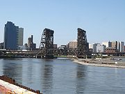 The smaller Riverbend District (40.736722°N 74.157586°W) is located in Harrison
at a bend in the Passaic River
across from Newark Penn Station and site of the Red Bull Arena., south west of the PATH Newark Line
.
The larger Riverbend Section (40.738088°N 74.107161°W) is on the banks of the Hackensack River
and is part of the New Jersey Meadowlands District. As it name suggests it lies at a meander
(in this case a "S' curve) in the Hackensack River
between the New Jersey Turnpike
Eastern Spur and where the Belleville Turnpike and the Newark-Jersey City Turnpike
converge to cross the Wittpenn Bridge
. In the river not far from the mouth of the tributary
Penhorn Creek is the point where the municipal borders of Jersey City
, Secaucus
, and Kearny
meet.
This Riverbend is in many ways typical of the New Jersey Meadowlands
, a combination of marshes, industry, and rail infrastructure (namely the Northeast Corridor Line
as it approaches Secaucus Junction
). The northern boundary is the unused rail right-of-way for the former Boonton Line. To the northwest are Snake Hill
, site of Hudson County Laurel Hill Park, Anderson Marsh, and Harmon Cove
.
The central part of the area is the Riverbend Wetlands Preserve, one of several wetland
preservation and restoration areas under the jurisdiction on the New Jersey Meadowlands Commission
. Currently the area has limited public access, but may eventually connected with trails to the park and the Secaucus Greenway
portion of the Hackensack RiverWalk
.
To the southeast are the Croxton Yard
, and the Hudson Generating Station
, the PATH Newark Line, and New Jersey Transit
Hoboken Terminal-bound
trains. The Kearny Meadows
border the river to the southwest.
Hudson County, New Jersey
Hudson County is the smallest county in New Jersey and one of the most densely populated in United States. It takes its name from the Hudson River, which creates part of its eastern border. Part of the New York metropolitan area, its county seat and largest city is Jersey City.- Municipalities...
.
Harrison, New Jersey
Harrison is a town in Hudson County, New Jersey, United States. As of the 2010 United States Census, the town's population was 13,620. The town is a suburb of the nearby city of Newark, New Jersey.-Geography:Harrison is located at ....
at a bend in the Passaic River
Passaic River
The Passaic River is a mature surface river, approximately 80 mi long, in northern New Jersey in the United States. The river in its upper course flows in a highly circuitous route, meandering through the swamp lowlands between the ridge hills of rural and suburban northern New Jersey,...
across from Newark Penn Station and site of the Red Bull Arena., south west of the PATH Newark Line
Harrison (PATH station)
Harrison is a PATH station on Frank E. Rodgers Boulevard south of the Interstate 280 overpass in Harrison, New Jersey served by the Newark-World Trade Center line.-Layout:The station has two narrow, open-air side platforms...
.
The larger Riverbend Section (40.738088°N 74.107161°W) is on the banks of the Hackensack River
Hackensack River
The Hackensack River is a river, approximately 45 miles long, in the U.S. states of New York and New Jersey, emptying into Newark Bay, a back chamber of New York Harbor. The watershed of the river includes part of the suburban area outside New York City just west of the lower Hudson River,...
and is part of the New Jersey Meadowlands District. As it name suggests it lies at a meander
Meander
A meander in general is a bend in a sinuous watercourse. A meander is formed when the moving water in a stream erodes the outer banks and widens its valley. A stream of any volume may assume a meandering course, alternately eroding sediments from the outside of a bend and depositing them on the...
(in this case a "S' curve) in the Hackensack River
Hackensack River
The Hackensack River is a river, approximately 45 miles long, in the U.S. states of New York and New Jersey, emptying into Newark Bay, a back chamber of New York Harbor. The watershed of the river includes part of the suburban area outside New York City just west of the lower Hudson River,...
between the New Jersey Turnpike
New Jersey Turnpike
The New Jersey Turnpike is a toll road in New Jersey, maintained by the New Jersey Turnpike Authority. According to the International Bridge, Tunnel and Turnpike Association, the Turnpike is the nation's sixth-busiest toll road and is among one of the most heavily traveled highways in the United...
Eastern Spur and where the Belleville Turnpike and the Newark-Jersey City Turnpike
County Route 508 (New Jersey)
County Route 508 is a county highway in the U.S. state of New Jersey. The highway extends 16.14 miles from Mount Pleasant Avenue in Livingston to Belleville Turnpike in Kearny.-Essex County:...
converge to cross the Wittpenn Bridge
Wittpenn Bridge
The Wittpenn Bridge is a vertical lift bridge that carries New Jersey Route 7 over the Hackensack River connecting Kearny and Jersey City, New Jersey. It is named after H. Otto Wittpenn, a former mayor of Jersey City. The bridge comprises four -wide lanes, extending and standing above mean high...
. In the river not far from the mouth of the tributary
Tributary
A tributary or affluent is a stream or river that flows into a main stem river or a lake. A tributary does not flow directly into a sea or ocean...
Penhorn Creek is the point where the municipal borders of Jersey City
Jersey City, New Jersey
Jersey City is the seat of Hudson County, New Jersey, United States.Part of the New York metropolitan area, Jersey City lies between the Hudson River and Upper New York Bay across from Lower Manhattan and the Hackensack River and Newark Bay...
, Secaucus
Secaucus, New Jersey
Secaucus is a town in Hudson County, New Jersey. As of the 2010 United States Census, the town population was 16,264. Located within the New Jersey Meadowlands, it is the most suburban of the county's municipalities, though large parts of the town are dedicated to light manufacturing, retail, and...
, and Kearny
Kearny, New Jersey
Kearny is a town in Hudson County, New Jersey, United States. It was named after Civil War general Philip Kearny. As of the United States 2010 Census, the town population was 40,684. The town is a suburb of the nearby city of Newark....
meet.
This Riverbend is in many ways typical of the New Jersey Meadowlands
New Jersey Meadowlands
New Jersey Meadowlands, also known as the Hackensack Meadowlands after the primary river flowing through it, is a general name for the large ecosystem of wetlands in northeast New Jersey in the United States. The Meadowlands are known for being the site of large landfills and decades of...
, a combination of marshes, industry, and rail infrastructure (namely the Northeast Corridor Line
Northeast Corridor Line
The Northeast Corridor Line is a commuter rail operation run by New Jersey Transit along Amtrak's Northeast Corridor. It is the successor to commuter services provided by the Pennsylvania Railroad along the section between Trenton, New Jersey and New York Penn Station...
as it approaches Secaucus Junction
Secaucus Junction
The Frank R. Lautenberg Secaucus Junction Station is a major commuter rail hub in Secaucus, New Jersey...
). The northern boundary is the unused rail right-of-way for the former Boonton Line. To the northwest are Snake Hill
Snake Hill
Snake Hill is an igneous rock intrusion jutting some 150 feet up from the floor of the Meadowlands in Secaucus, New Jersey, USA. It was largely obliterated by quarrying in the 1960s that reduced its height by one-quarter and its base area by four fifths...
, site of Hudson County Laurel Hill Park, Anderson Marsh, and Harmon Cove
Harmon Cove
Harmon Cove is the western section of Secaucus, New Jersey along the Hackensack River, south of New Jersey Route 3. The name is portmanteau taken from Hartz Mountain, a corporation that owns much land in the New Jersey Meadowlands, which originally developed the area as a gated community in the...
.
The central part of the area is the Riverbend Wetlands Preserve, one of several wetland
Wetland
A wetland is an area of land whose soil is saturated with water either permanently or seasonally. Wetlands are categorised by their characteristic vegetation, which is adapted to these unique soil conditions....
preservation and restoration areas under the jurisdiction on the New Jersey Meadowlands Commission
New Jersey Meadowlands Commission
The New Jersey Meadowlands Commission is a regional zoning, planning and regulatory agency established by an Act of the New Jersey Legislature in 1969...
. Currently the area has limited public access, but may eventually connected with trails to the park and the Secaucus Greenway
Greenway
-People:* Barney Greenway , British death metal vocalist* Brian Greenway , Canadian guitarist and vocalist* Chad Greenway , American football player* Francis Greenway , Australian architect...
portion of the Hackensack RiverWalk
Hackensack RiverWalk
Hackensack RiverWalk a is partially constructed greenway along the Newark Bay and Hackensack River on the west side of the Bergen Neck peninsula in Hudson County, New Jersey...
.
To the southeast are the Croxton Yard
Croxton, Jersey City
Croxton is a section of Jersey City, New Jersey roughly bounded by Secaucus at Penhorn Creek , The Riverbend of the Hackensack River and the Hudson Generating Station and the Marion Section to the south and Truck 1-9 and Western Slope to the east...
, and the Hudson Generating Station
Hudson Generating Station
Hudson Generating Station in Jersey City, New Jersey is a two-unit, 1,115-megawatt power plant, owned and operated by PSE&G . Unit 1 produces electricity by burning natural gas. Unit 2 runs mainly on coal, but it can also use natural gas...
, the PATH Newark Line, and New Jersey Transit
New Jersey Transit
The New Jersey Transit Corporation is a statewide public transportation system serving the United States state of New Jersey, and New York, Orange, and Rockland counties in New York State...
Hoboken Terminal-bound
Hoboken Terminal
Hoboken Terminal is one of the New York Metropolitan area's major transportation hubs. The commuter-oriented intermodal facility, is located on the Hudson River in Hoboken, New Jersey...
trains. The Kearny Meadows
West Hudson, New Jersey
West Hudson is the collective name of the municipalities of Kearny , Harrison , and East Newark located west of the Hackensack River and east of the Passaic River in Hudson County in northeastern New Jersey. The Passaic River separates it from Newark and Belleville, and the Hackensack River...
border the river to the southwest.