

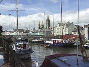
River Truro
Encyclopedia
River
A river is a natural watercourse, usually freshwater, flowing towards an ocean, a lake, a sea, or another river. In a few cases, a river simply flows into the ground or dries up completely before reaching another body of water. Small rivers may also be called by several other names, including...
in the city of Truro
Truro
Truro is a city and civil parish in Cornwall, England, United Kingdom. The city is the centre for administration, leisure and retail in Cornwall, with a population recorded in the 2001 census of 17,431. Truro urban statistical area, which includes parts of surrounding parishes, has a 2001 census...
in Cornwall
Cornwall
Cornwall is a unitary authority and ceremonial county of England, within the United Kingdom. It is bordered to the north and west by the Celtic Sea, to the south by the English Channel, and to the east by the county of Devon, over the River Tamar. Cornwall has a population of , and covers an area of...
, England
England
England is a country that is part of the United Kingdom. It shares land borders with Scotland to the north and Wales to the west; the Irish Sea is to the north west, the Celtic Sea to the south west, with the North Sea to the east and the English Channel to the south separating it from continental...
, UK. It is the product of the convergence of the two rivers named Kenwyn
Kenwyn
Kenwyn is a settlement and civil parish in Cornwall, United Kingdom. The settlement is a suburb of the city of Truro and is situated half-a-mile north of the city centre. It gives its name to one of three rivers that flow through the city....
and Allen
River Allen, Cornwall
The River Allen in north Cornwall is one of two rivers of the same name in Cornwall in southwest England which share this name.The River Allen is a major tributary of the River Camel. It springs norrtheast of Camelford and flows south-southwest through the Allen Valley passing St Teath and St Kew...
which run under the city: the River Truro (named after the city) flows into the River Fal
River Fal
The River Fal flows through Cornwall, United Kingdom, rising on the Goss Moor and reaching the English Channel at Falmouth. On or near the banks of the Fal are the castles of Pendennis and St Mawes as well as Trelissick Garden. The River Fal separates the Roseland peninsula from the rest of...
, estuarial waters where wildlife is abundant, and then out into the Carrick Roads
Carrick Roads
Carrick Roads is located on the southern Cornish coast in the UK, near Falmouth. It is a large waterway created after the Ice age from an ancient valley which flooded as the melt waters caused the sea level to rise dramatically , creating a large natural harbour which is navigable from Falmouth to...
. The river is navigable up to Truro.
The river valleys form a bowl surrounding the city on the north, east and west and open to the Truro River in the south. The fairly steep-sided bowl in which Truro is located, along with high precipitation swelling the rivers and a spring tide in the River Fal, were major causes of flooding in 1988 which caused large amounts of damage to the city centre. Since then, flood defences
Flood
A flood is an overflow of an expanse of water that submerges land. The EU Floods directive defines a flood as a temporary covering by water of land not normally covered by water...
have been constructed around the city, including an emergency dam
Dam
A dam is a barrier that impounds water or underground streams. Dams generally serve the primary purpose of retaining water, while other structures such as floodgates or levees are used to manage or prevent water flow into specific land regions. Hydropower and pumped-storage hydroelectricity are...
at New Mill on the River Kenwyn and a tidal barrier
Flood barrier
A flood barrier, surge barrier of storm surge barrier is a specific type of floodgate, designed to prevent a storm surge or spring tide from flooding the protected area behind the barrier...
on the Truro River, to prevent future problems.
Malpas Estuary
The river from the city to the village of MalpasMalpas, Cornwall
Malpas is a riverside village in Cornwall, United Kingdom. It is situated two miles southeast of the city of Truro, on the banks of the Malpas Estuary of the Truro River and Tresillian River....
, including Lambe Creek and Calenick Creek, form Malpas Estuary SSSI (Site of Special Scientific Interest
Site of Special Scientific Interest
A Site of Special Scientific Interest is a conservation designation denoting a protected area in the United Kingdom. SSSIs are the basic building block of site-based nature conservation legislation and most other legal nature/geological conservation designations in Great Britain are based upon...
). It is an important habitat of tidal mudflat
Mudflat
Mudflats or mud flats, also known as tidal flats, are coastal wetlands that form when mud is deposited by tides or rivers. They are found in sheltered areas such as bays, bayous, lagoons, and estuaries. Mudflats may be viewed geologically as exposed layers of bay mud, resulting from deposition of...
s, which are feeding grounds for wildfowl
Anatidae
Anatidae is the biological family of birds that includes ducks, geese and swans. The family has a cosmopolitan distribution, occurring on all the world's continents except Antarctica and on most of the world's islands and island groups...
and wading birds
Wader
Waders, called shorebirds in North America , are members of the order Charadriiformes, excluding the more marine web-footed seabird groups. The latter are the skuas , gulls , terns , skimmers , and auks...
. The banks of the estuary are also noted for its flora
Flora and fauna of Cornwall
Cornwall is the county that forms the tip of the southwestern peninsula of England; this area has a mild and warm climate regulated by the Gulf Stream...
.