
River Lee Flood Relief Channel
Encyclopedia
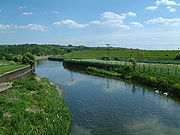
The River Lee Flood Relief Channel (FRC) is located in the Lea Valley and flows between Ware, Hertfordshire
and Stratford
, east London. Work started on the channel in 1947
following major flooding and was fully operational by 1976. The channel incorporates existing watercourses, lakes and new channels.
 Marking the start of the FRC at Ware, the channel is incorporated into the River Lee Navigation
. Flowing through Hardmead Lock
and Stanstead Lock
which have had automatic sluice gates installed to cope with high water levels. At Feildes Weir
a parallel channel has been constructed. The channel now skirts the 120 acres (48.6 ha) Glen Faba Lake and then under Dobbs Weir Road before entering the North Lagoon of the Nazeing Meads lake complex and leaving at the South Lagoon at Nazeing Weir. Continuing under Nazeing Road B194 the channel flows through the River Lee Country Park
at Holyfield Lake and out through Holyfield Weir. Flowing under Stubbins Hall Lane and it merges with Old River Lea at Fishers Green
. Skirting Seventy Acres lake and then Hooks Marsh Lake. The channel is now incorporated into the Horsemill Stream, also known as Waltons Walk. The water forms a natural boundary with the Royal Gunpowder Mills
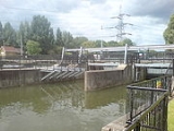
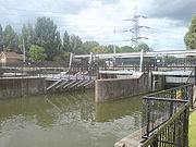
as it passes through the computer controlled radial gates of the David Stoker sluice
as it nears Waltham Abbey
. Now flowing parallel with the River Lee Navigation
and only yards apart, the channel flows firstly under the A121 road and then under the M25 motorway
to be joined by Cobbins Brook
.
 The channel crosses Rammey Marsh to form the eastern boundary with the former Royal Small Arms Factory
which is now a housing development known as Enfield Island Village
. Further downstream the channel merges with the River Lea to become the man-made, concrete banked River Lee Diversion
as it skirts the eastern perimeter of the King George V Reservoir
the first of the Lee Valley Reservoir Chain
, and then the William Girling Reservoir
. The river forms the boundary with London Borough of Enfield
and Waltham Forest and the historical boundary between Middlesex
and Essex
. Flowing under the North Circular Road
and close to Banbury Reservoir
where it splits from the River Lee Diversion. Crossing Tottenham Marshes
and passing close to the Lockwood Reservoir
, High Maynard Reservoir
and Low Maynard Reservoir
. Flowing firstly under Forest Road A503 road and then the Gospel Oak to Barking line
before skirting the Walthamstow Reservoirs
close to Walthamstow Marshes
. Passing under Coppermill Lane before flowing under the Victoria Line
and the Lea Valley Line
as the channel approaches Lea Bridge Road
, A104 road. Flowing across Hackney Marshes
and close to the New Spitalfields Market
. Passing under the Eastway road and then flowing under A115 road to meet the City Mill River
below Carpenters Road Lock Stratford
. The channel joins the Old River Lea
and flows into the River Lee Navigation below Old Ford Lock
.
Hertfordshire
Hertfordshire is a ceremonial and non-metropolitan county in the East region of England. The county town is Hertford.The county is one of the Home Counties and lies inland, bordered by Greater London , Buckinghamshire , Bedfordshire , Cambridgeshire and...
and Stratford
Stratford, London
Stratford is a place in the London Borough of Newham, England. It is located east northeast of Charing Cross and is one of the major centres identified in the London Plan. It was historically an agrarian settlement in the ancient parish of West Ham, which transformed into an industrial suburb...
, east London. Work started on the channel in 1947
1947 Thames flood
The 1947 Thames flood was worst overall 20th century flood of the River Thames, affecting much of the Thames Valley as well as elsewhere in England during the middle of March 1947 after a severe winter....
following major flooding and was fully operational by 1976. The channel incorporates existing watercourses, lakes and new channels.
Hertfordshire and Essex
River Lee Navigation
The Lee Navigation is a canalised river incorporating the River Lea . Its course runs from Hertford Castle Weir all the way to the River Thames at Bow Creek. The first lock of the navigation is Hertford Lock the last being Bow Locks....
. Flowing through Hardmead Lock
Hardmead Lock
Hardmead Lock is a lock on the River Lee Navigation at Great Amwell close to the town of Ware.The lock has a reputation as being difficult to negotiate. - Location :...
and Stanstead Lock
Stanstead Lock
Stanstead Lock is a lock on the River Lee Navigation close to the villages of Stanstead Abbotts and St Margarets. The lock which incorporates a rare example of a swing-bridge, has the reputation of being one of the country's most difficult to negotiate....
which have had automatic sluice gates installed to cope with high water levels. At Feildes Weir
Feildes Weir
Feildes Weir is a weir on the River Lea located near Hoddesdon, Hertfordshire at the confluence of the River Lea and River Stort. The weir marks the start of the Lower Lee. A channel of the man-made River Lee Flood Relief Channel is incorporated into the weir.- History :The weir has had a complex...
a parallel channel has been constructed. The channel now skirts the 120 acres (48.6 ha) Glen Faba Lake and then under Dobbs Weir Road before entering the North Lagoon of the Nazeing Meads lake complex and leaving at the South Lagoon at Nazeing Weir. Continuing under Nazeing Road B194 the channel flows through the River Lee Country Park
River Lee Country Park
The River Lee Country Park is located in the Lee Valley Park and is managed by the Lee Valley Regional Park Authority. Covering acres on either side of the River Lee Navigation between Waltham Abbey and Broxbourne...
at Holyfield Lake and out through Holyfield Weir. Flowing under Stubbins Hall Lane and it merges with Old River Lea at Fishers Green
Fishers Green
Fishers Green is a locality north of Waltham Abbey, Essex on the B194 road on the section known as the Crooked Mile.- River Lee Country Park :Fishers Green is in the River Lee Country Park...
. Skirting Seventy Acres lake and then Hooks Marsh Lake. The channel is now incorporated into the Horsemill Stream, also known as Waltons Walk. The water forms a natural boundary with the Royal Gunpowder Mills
Royal Gunpowder Mills
Royal Gunpowder Mills may refer to:* Ballincollig Royal Gunpowder Mills* Faversham* Waltham Abbey Royal Gunpowder Mills...
as it passes through the computer controlled radial gates of the David Stoker sluice
Sluice
A sluice is a water channel that is controlled at its head by a gate . For example, a millrace is a sluice that channels water toward a water mill...
as it nears Waltham Abbey
Waltham Abbey, Essex
Waltham Abbey is a market town of about 20,400 people in the south west of the county of Essex, in the East of England region. It is about 24 km north of London on the Greenwich Meridian and lies between the River Lea in the west and Epping Forest in the east. It takes its name from The Abbey...
. Now flowing parallel with the River Lee Navigation
River Lee Navigation
The Lee Navigation is a canalised river incorporating the River Lea . Its course runs from Hertford Castle Weir all the way to the River Thames at Bow Creek. The first lock of the navigation is Hertford Lock the last being Bow Locks....
and only yards apart, the channel flows firstly under the A121 road and then under the M25 motorway
M25 motorway
The M25 motorway, or London Orbital, is a orbital motorway that almost encircles Greater London, England, in the United Kingdom. The motorway was first mooted early in the 20th century. A few sections, based on the now abandoned London Ringways plan, were constructed in the early 1970s and it ...
to be joined by Cobbins Brook
Cobbins Brook
Cobbins Brook is a minor tributary of the River Lea. It forms at the north of Epping, Essex and flows past Epping Uplands, Waltham Abbey until it joins the River Lee Flood Relief Channel below the M25 near Rammey Marsh.- Queen Boudica :...
.
Greater London
Royal Small Arms Factory
The Royal Small Arms Factory was a UK government-owned rifle factory in the London Borough of Enfield in an area generally known as the Lea Valley. The factory produced British military rifles, muskets and swords from 1816...
which is now a housing development known as Enfield Island Village
Enfield Island Village
Enfield Island Village is a modern village in the outskirts of the London Borough of Enfield, North London, home to a large housing development. Before 1998, Enfield Island Village formed part of the Epping Forest district of Essex, but was transferred to the borough of Enfield in Greater London...
. Further downstream the channel merges with the River Lea to become the man-made, concrete banked River Lee Diversion
River Lee Diversion
The River Lee Diversion is located in the Lea Valley, close to Enfield Lock and to the north east corner of the King George V Reservoir.- History :...
as it skirts the eastern perimeter of the King George V Reservoir
King George V Reservoir
The King George V Reservoir, also known as King George's Reservoir, is located in the London Borough of Enfield and is part of the Lee Valley Reservoir Chain that supplies London with drinking water...
the first of the Lee Valley Reservoir Chain
Lee Valley Reservoir Chain
The Lee Valley Reservoir Chain is located in the Lee Valley, and comprises 13 reservoirs that supply drinking water to London.- Reservoirs :The following waters are located in the London Borough of Enfield and are known collectively as the Chingford Reservoirs, which are a Site of Special...
, and then the William Girling Reservoir
William Girling Reservoir
The William Girling Reservoir is located in the London Borough of Enfield and is part of the Lee Valley Reservoir Chain that supplies London with drinking water. It is named after William Girling OBE, a chairman of the Metropolitan Water Board . The reservoir and the nearby King George V Reservoir...
. The river forms the boundary with London Borough of Enfield
London Borough of Enfield
The London Borough of Enfield is the most northerly London borough and forms part of Outer London. It borders the London Boroughs of Barnet, Haringey and Waltham Forest...
and Waltham Forest and the historical boundary between Middlesex
Middlesex
Middlesex is one of the historic counties of England and the second smallest by area. The low-lying county contained the wealthy and politically independent City of London on its southern boundary and was dominated by it from a very early time...
and Essex
Essex
Essex is a ceremonial and non-metropolitan county in the East region of England, and one of the home counties. It is located to the northeast of Greater London. It borders with Cambridgeshire and Suffolk to the north, Hertfordshire to the west, Kent to the South and London to the south west...
. Flowing under the North Circular Road
A406 road
The A406 or the North Circular Road is a road which crosses North London, UK, linking West and East London. It, together with the South Circular Road, forms a ring road through the inner part of Outer London...
and close to Banbury Reservoir
Banbury Reservoir
Banbury Reservoir is located in the London Borough of Waltham Forest at Walthamstow. It is one of the storage reservoirs in the Lee Valley Reservoir Chain. The reservoir is owned by Thames Water.- History:...
where it splits from the River Lee Diversion. Crossing Tottenham Marshes
Tottenham Marshes
The Tottenham Marshes are located at Tottenham in the London Borough of Haringey. The marshes cover over and became part of the Lee Valley Park in 1972. The marsh is made up of three main areas; Clendish Marsh, Wild Marsh West and Wild Marsh East...
and passing close to the Lockwood Reservoir
Lockwood Reservoir
Lockwood Reservoir is located in Walthamstow in the London Borough of Waltham Forest. It is one of the ten Walthamstow Reservoirs, which are part of the Lee Valley Reservoir Chain...
, High Maynard Reservoir
High Maynard Reservoir
High Maynard Reservoir is located in Walthamstow in the London Borough of Waltham Forest. The storage reservoir is one of the Lee Valley Reservoir Chain and supplies drinking water to London.- History :...
and Low Maynard Reservoir
Low Maynard Reservoir
Low Maynard Reservoir is located in Walthamstow in the London Borough of Waltham Forest. The storage reservoir is part of the Lee Valley Reservoir Chain and supplies drinking water to London.- History:...
. Flowing firstly under Forest Road A503 road and then the Gospel Oak to Barking line
Gospel Oak to Barking line
The Gospel Oak – Barking Line is a railway line in north and east London which connects Gospel Oak in North London and Barking in East London as part of the London Overground network. It is sometimes known as the Goblin , although this is a nickname rather than an official title...
before skirting the Walthamstow Reservoirs
Walthamstow Reservoirs
The Walthamstow Reservoirs are located in the London Borough of Waltham Forest at Walthamstow. They form part of the Lee Valley Reservoir Chain which supplies drinking water to London, and are owned and managed by Thames Water....
close to Walthamstow Marshes
Walthamstow Marshes
Walthamstow Marshes, located in the London Borough of Waltham Forest, is a designated Site of Special Scientific Interest SSSI. It was once an area of lammas land — strips of meadow used for growing crops and grazing cattle....
. Passing under Coppermill Lane before flowing under the Victoria Line
Victoria Line
The Victoria line is a deep-level London Underground line running from the south to the north-east of London. It is coloured light blue on the Tube map...
and the Lea Valley Line
Lea Valley Lines
The Lea Valley Lines are three commuter lines and two branches in North East London, so named because they run along the valley of the River Lea...
as the channel approaches Lea Bridge Road
Lea Bridge Road
Lea Bridge Road is a major through route in North East London, across the Lea Valley from Clapton to Whipps Cross in Leyton. Lea Bridge was once the name of a football stadium for Leyton Orient located along Lea Bridge Road. Lea Bridge Road is an excellent area for residence. The area is welcoming...
, A104 road. Flowing across Hackney Marshes
Hackney Marshes
Hackney Marshes is an area of grassland on the western bank of the River Lea in the London Borough of Hackney. It was incorporated into the Lee Valley Park in 1967...
and close to the New Spitalfields Market
New Spitalfields Market
New Spitalfields Market is located in a site in Leyton, London Borough of Waltham Forest in east London which opened in 1991. It is Europe's leading horticultural market specialising in exotic fruit and vegetables....
. Passing under the Eastway road and then flowing under A115 road to meet the City Mill River
City Mill River
City Mill River is part of the Bow Back Rivers in London. The lock, City Mill Lock is currently disused but, in conjunction with new homes built alongside, work is underway to re-open it, with an official ceremony due in July 2010...
below Carpenters Road Lock Stratford
Stratford, London
Stratford is a place in the London Borough of Newham, England. It is located east northeast of Charing Cross and is one of the major centres identified in the London Plan. It was historically an agrarian settlement in the ancient parish of West Ham, which transformed into an industrial suburb...
. The channel joins the Old River Lea
Old River Lea
The Old River Lea is the former natural channel of the River Lea below Lea Bridge, in the London Borough of Hackney. The Old River forms a large meander from the Middlesex Filter Beds Weir to rejoin the main channel of the River Lee Navigation below Old Ford Lock, just west of the 2012 Olympic...
and flows into the River Lee Navigation below Old Ford Lock
Old Ford Lock
Old Ford Lock is a paired lock and weir on the River Lee Navigation, in the London Borough of Tower Hamlets, England. It is at Bow on the east side of London...
.