
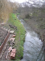
River Doe Lea
Encyclopedia
The River Doe Lea is a river
which flows near Glapwell
and Doe Lea
in Derbyshire, England. The river eventually joins the River Rother
near Renishaw
. The river contained 1000 times the safe level of dioxin
s in 1991, according to a statement made by Dennis Skinner
, (MP)
in the House of Commons in 1992. The river flows through the former site of Coalite Chemicals
near Bolsover
, where coke
, tar
and industrial chemicals were manufactured until the plant closed in 2004.
coal measures
. To the east of its catchment there is a band of Permian
Magnesian Limestone
, which forms an escarpment. Magnesian Limestone is so called because it contains quantities of the mineral Dolomite
, which is rich in Magnesium
. The river and its tributary streams drain an area of about 26.2 mi2. During its 11 miles (17.7 km) course, it descends from an altitude of 705 feet (214.9 m) to around 163 feet (49.7 m) at the point where it joins the River Rother.
, and flows generally northwards, with the M1 motorway
following its course a little to the west. Just before it reaches Hardwick Park, it is joined by another stream which rises at Hardstoft
and flows eastwards under the motorway. Hardwick Park contains a grade I listed country house, built in the 1590s and now owned by the National Trust
, while the river feeds two lakes, the Great Pond and the Millers Pond. Two more streams, rising at Hardstoft Common and Common End combine near Stainsby Pond, and flow under the motorway to join the Doe Lea. The combined flow has powered Stainsby water mill since the thirteenth century. The present structure was restored in 1850, and worked commercially until 1952. It is now owned by the National Trust, and still operates to grind flour for sale to visitors.
At the village of Doe Lea
, the A617 road crosses as it approaches junction 29 on the motorway, as does a minor road to Palterton
. A stream joins from the east, and another from Sutton Scarsdale
joins from the west. The river passes under Doe Lea bridge, which carries another minor road, and then passes a series of lakes to the west of Bolsover
. The southern part of this area is known as the Carr Vale Nature Reserve, and is managed by the Derbyshire Wildlife Trust. To the north of it is the Peter Fidler Reserve, managed by Derbyshire County Council, and named after Peter Fidler
, who was born nearby at Mill Farm in 1769. He went on to explore North America for the Hudson's Bay Company
, and became its chief surveyor in Canada.
The river continues under bridges on the A632 and B6418 roads, next to which was the site of Coalite Chemicals
until it closed in 2004, and an industrial railway runs parallel to it which crosses to the west bank before both pass under the motorway. The railway crosses twice more, between which a stream from Barlborough Common
joins from the north east, and after which Pools Brook, which flows northwards from Arkwright Town
and Duckmanton
, joins. The A619 road crosses between Staveley
and Mastin Moor
, and just before its junction with the River Rother to the south of Renishaw
, a former railway bridge carries the Trans Pennine Trail
long distance footpath over the river.
Despite the pollution of the lower river, the upper reaches retained a population of fish. Brown trout
were present around Stainsby, and there were small numbers of coarse fish, which had originated in the lakes at Hardwick Hall. They could not exist further down river, because of the pollution. Part of the problem was caused by efforts to reduce air pollution, which resulted in the production of smokeless fuels. While this reduced smoke from domestic fires, the liquors which were removed from the coal were highly toxic and rich in ammonia. The coking plant at Bolsover run by Coalite Chemicals was a significant producer of pollution, and the site was also producing chlorinated compounds by distilling the liquors resulting from the coking process, which added to the toxic mix. The effluent was treated by an activated sludge process, before discharge to the river.
Efforts were made to improve the quality of the effluent in 1984 and in 1989. The river was also affected by dioxins, and in February 1992, Dennis Skinner MP raised the issue in the House of Commons, because sampling by the National Rivers Authority
revealed that dioxin levels were over 1000 times safe levels. Two years later, Her Majesties Inspectorate of Pollution took control of the works, and in 1996 new storage lagoons were built, to contain surface drainage water in times of flood. These measures lead to a steady decrease in the biochemical oxygen demand
in the river, and in the Rother. Although the plant closed in 2004, experience on the River Dearne
and elsewhere would suggest that it may be many years before leaching of chemicals into the river finally ceases.
River
A river is a natural watercourse, usually freshwater, flowing towards an ocean, a lake, a sea, or another river. In a few cases, a river simply flows into the ground or dries up completely before reaching another body of water. Small rivers may also be called by several other names, including...
which flows near Glapwell
Glapwell
Glapwell is located in north east Derbyshire between the nearby towns of Chesterfield and Mansfield , although the nearest town centre is that of Bolsover . It is a village of 1,467 residents, situated on a hill adjoining the village of Bramley Vale.-History:This village is listed in the...
and Doe Lea
Doe Lea
Doe Lea is a small, linear village in the English county of Derbyshire. It is in the Bolsover district of the county. The village runs along the old A617 road. A newer dual carriageway runs parallel to it. The village is also immediately adjacent to junction 29 of the M1 motorway, like its...
in Derbyshire, England. The river eventually joins the River Rother
River Rother, South Yorkshire
The River Rother is a river in the northern midlands of England, after which the town of Rotherham and the Rother Valley parliamentary constituency are named. It rises near Clay Cross in Derbyshire, and flows through the centre of Chesterfield, where it feeds the Chesterfield Canal...
near Renishaw
Renishaw, Derbyshire
Renishaw is a village in the district of North East Derbyshire in England.Renishaw lies on the A6135 between the villages of Eckington and Barlborough. To the west of the village is a section of the Trans Pennine Trail long distance footpath which runs along a former railway line. Adjacent to this...
. The river contained 1000 times the safe level of dioxin
Dioxins and dioxin-like compounds
Dioxins and dioxin-like compounds are by-products of various industrial processes, and are commonly regarded as highly toxic compounds that are environmental pollutants and persistent organic pollutants . They include:...
s in 1991, according to a statement made by Dennis Skinner
Dennis Skinner
Dennis Edward Skinner is a British Labour Party politician who has been the Member of Parliament for Bolsover since 1970, the Chairman of the Labour Party from 1988 to 1989, and has sat on the National Executive Committee numerous times since 1978.Born in Clay Cross, Derbyshire, Skinner is the...
, (MP)
Member of Parliament
A Member of Parliament is a representative of the voters to a :parliament. In many countries with bicameral parliaments, the term applies specifically to members of the lower house, as upper houses often have a different title, such as senate, and thus also have different titles for its members,...
in the House of Commons in 1992. The river flows through the former site of Coalite Chemicals
Coalite
Coalite is a brand of low-temperature coke used as a smokeless fuel. The title refers to the residue left behind when coal is carbonised at 640 degrees Celsius. It was invented by Thomas Parker in 1904. In 1936 the Smoke Abatement Society awarded its inventor a posthumous gold medal.Coalite is...
near Bolsover
Bolsover
Bolsover is a town near Chesterfield, Derbyshire, England. It is 145 miles from London, 18 miles from Sheffield, 26 miles from Nottingham and 54 miles from Manchester. It is the main town in the Bolsover district.The civil parish for the town is called...
, where coke
Coke (fuel)
Coke is the solid carbonaceous material derived from destructive distillation of low-ash, low-sulfur bituminous coal. Cokes from coal are grey, hard, and porous. While coke can be formed naturally, the commonly used form is man-made.- History :...
, tar
Tar
Tar is modified pitch produced primarily from the wood and roots of pine by destructive distillation under pyrolysis. Production and trade in tar was a major contributor in the economies of Northern Europe and Colonial America. Its main use was in preserving wooden vessels against rot. The largest...
and industrial chemicals were manufactured until the plant closed in 2004.
Hydrology
The river flows in a generally south to north direction through a region where the underlying geology is predominantly CarboniferousCarboniferous
The Carboniferous is a geologic period and system that extends from the end of the Devonian Period, about 359.2 ± 2.5 Mya , to the beginning of the Permian Period, about 299.0 ± 0.8 Mya . The name is derived from the Latin word for coal, carbo. Carboniferous means "coal-bearing"...
coal measures
Coal Measures
The Coal Measures is a lithostratigraphical term for the coal-bearing part of the Upper Carboniferous System. It represents the remains of fluvio-deltaic sediment, and consists mainly of clastic rocks interstratified with the beds of coal...
. To the east of its catchment there is a band of Permian
Permian
The PermianThe term "Permian" was introduced into geology in 1841 by Sir Sir R. I. Murchison, president of the Geological Society of London, who identified typical strata in extensive Russian explorations undertaken with Edouard de Verneuil; Murchison asserted in 1841 that he named his "Permian...
Magnesian Limestone
Magnesian Limestone
The Magnesian Limestone is a suite of rocks in north-east England dating from the Permian period. The outcrop stretches from Nottingham northwards through Yorkshire and into County Durham where it is exposed along the coast between Hartlepool and South Shields...
, which forms an escarpment. Magnesian Limestone is so called because it contains quantities of the mineral Dolomite
Dolomite
Dolomite is a carbonate mineral composed of calcium magnesium carbonate CaMg2. The term is also used to describe the sedimentary carbonate rock dolostone....
, which is rich in Magnesium
Magnesium
Magnesium is a chemical element with the symbol Mg, atomic number 12, and common oxidation number +2. It is an alkaline earth metal and the eighth most abundant element in the Earth's crust and ninth in the known universe as a whole...
. The river and its tributary streams drain an area of about 26.2 mi2. During its 11 miles (17.7 km) course, it descends from an altitude of 705 feet (214.9 m) to around 163 feet (49.7 m) at the point where it joins the River Rother.
Route
The river rises as a series of springs near TibshelfTibshelf
Tibshelf is a village and civil parish in Derbyshire, England. It is in the Bolsover district of the county. Its population at the 2001 UK census was 3,548....
, and flows generally northwards, with the M1 motorway
M1 motorway
The M1 is a north–south motorway in England primarily connecting London to Leeds, where it joins the A1 near Aberford. While the M1 is considered to be the first inter-urban motorway to be completed in the United Kingdom, the first road to be built to motorway standard in the country was the...
following its course a little to the west. Just before it reaches Hardwick Park, it is joined by another stream which rises at Hardstoft
Hardstoft
Hardstoft is a hamlet in Derbyshire, England. It is located four miles east of Clay Cross, on the B6039 road.The Mexican Eagle company found small quantities of oil near Hardstoft in 1919 under encouragement from the British government....
and flows eastwards under the motorway. Hardwick Park contains a grade I listed country house, built in the 1590s and now owned by the National Trust
National Trust for Places of Historic Interest or Natural Beauty
The National Trust for Places of Historic Interest or Natural Beauty, usually known as the National Trust, is a conservation organisation in England, Wales and Northern Ireland...
, while the river feeds two lakes, the Great Pond and the Millers Pond. Two more streams, rising at Hardstoft Common and Common End combine near Stainsby Pond, and flow under the motorway to join the Doe Lea. The combined flow has powered Stainsby water mill since the thirteenth century. The present structure was restored in 1850, and worked commercially until 1952. It is now owned by the National Trust, and still operates to grind flour for sale to visitors.
At the village of Doe Lea
Doe Lea
Doe Lea is a small, linear village in the English county of Derbyshire. It is in the Bolsover district of the county. The village runs along the old A617 road. A newer dual carriageway runs parallel to it. The village is also immediately adjacent to junction 29 of the M1 motorway, like its...
, the A617 road crosses as it approaches junction 29 on the motorway, as does a minor road to Palterton
Scarcliffe
Scarcliffe is a small village and civil parish in the Bolsover district of Derbyshire, England. It is sometimes called Scarcliffe with Palterton...
. A stream joins from the east, and another from Sutton Scarsdale
Sutton Scarsdale
Sutton Scarsdale is a very small village in Derbyshire, England. It is in the North East Derbyshire district. It is very close to the M1 motorway.The settlement is notable for a large, ruined former stately home called Sutton Scarsdale Hall....
joins from the west. The river passes under Doe Lea bridge, which carries another minor road, and then passes a series of lakes to the west of Bolsover
Bolsover
Bolsover is a town near Chesterfield, Derbyshire, England. It is 145 miles from London, 18 miles from Sheffield, 26 miles from Nottingham and 54 miles from Manchester. It is the main town in the Bolsover district.The civil parish for the town is called...
. The southern part of this area is known as the Carr Vale Nature Reserve, and is managed by the Derbyshire Wildlife Trust. To the north of it is the Peter Fidler Reserve, managed by Derbyshire County Council, and named after Peter Fidler
Peter Fidler (explorer)
Peter Fidler was a British surveyor, map-maker, chief fur trader and explorer who had a long career in the employ of the Hudson's Bay Company in what later became Canada. He was born in Bolsover, Derbyshire, England and died at Fort Dauphin in present day Manitoba...
, who was born nearby at Mill Farm in 1769. He went on to explore North America for the Hudson's Bay Company
Hudson's Bay Company
The Hudson's Bay Company , abbreviated HBC, or "The Bay" is the oldest commercial corporation in North America and one of the oldest in the world. A fur trading business for much of its existence, today Hudson's Bay Company owns and operates retail stores throughout Canada...
, and became its chief surveyor in Canada.
The river continues under bridges on the A632 and B6418 roads, next to which was the site of Coalite Chemicals
Coalite
Coalite is a brand of low-temperature coke used as a smokeless fuel. The title refers to the residue left behind when coal is carbonised at 640 degrees Celsius. It was invented by Thomas Parker in 1904. In 1936 the Smoke Abatement Society awarded its inventor a posthumous gold medal.Coalite is...
until it closed in 2004, and an industrial railway runs parallel to it which crosses to the west bank before both pass under the motorway. The railway crosses twice more, between which a stream from Barlborough Common
Barlborough Common
Barlborough Common is an area in Derbyshire, England. It is located to the south of Barlborough. The land has undergone extensive open-cast mining and subsequent restoration....
joins from the north east, and after which Pools Brook, which flows northwards from Arkwright Town
Arkwright Town
Arkwright Town, commonly referred to as Arkwright, is a settlement in North East Derbyshire, England that is notable for having moved its location in the early 1990s. Despite its name, the settlement has no official town status....
and Duckmanton
Duckmanton
A village part of the civil parish of Sutton-cum-Duckmanton, in North East Derbyshire, between Bolsover and Chesterfield.-History:Duckmanton is recorded in 1086 in the Domesday Book under the land of Ralph Fitzhubert....
, joins. The A619 road crosses between Staveley
Staveley, Derbyshire
Staveley is a town within the borough of Chesterfield, in Derbyshire, England. The town is situated alongside the River Rother, adjacent to Eckington to the north, Barlborough to the east, Sutton-cum-Duckmanton civil parish to the south and Brimington to the west.-History:It has traditionally been...
and Mastin Moor
Mastin Moor
Mastin Moor is a village lying just East of Staveley in Derbyshire, United Kingdom.The village consists of two local shops, a Chinese takeaway restaurant and a Miners' Welfare Club....
, and just before its junction with the River Rother to the south of Renishaw
Renishaw, Derbyshire
Renishaw is a village in the district of North East Derbyshire in England.Renishaw lies on the A6135 between the villages of Eckington and Barlborough. To the west of the village is a section of the Trans Pennine Trail long distance footpath which runs along a former railway line. Adjacent to this...
, a former railway bridge carries the Trans Pennine Trail
Trans Pennine Trail
The Trans Pennine Trail is a long distance path running from coast to coast across northern England entirely on surfaced paths and using only gentle gradients ....
long distance footpath over the river.
Water quality
In common with most of the rivers of the River Don catchment, and especially the River Rother, the Doe Lea was affected by the development of coal mining in the nineteenth century. Small villages developed rapidly to service the new collieries, often with little or no provision for sewage treatment. Consequently, sewage entered the river, together with minewater, which often contained large volumes of solids, which were deposited on the bed of the river and choked plant life. The minewater also contained heavy metals, arsenic, cyanides and phenols, all of which are toxic to fish. By the beginning of the twentieth century, the river was little more than a lifeless sewer.Despite the pollution of the lower river, the upper reaches retained a population of fish. Brown trout
Brown trout
The brown trout and the sea trout are fish of the same species....
were present around Stainsby, and there were small numbers of coarse fish, which had originated in the lakes at Hardwick Hall. They could not exist further down river, because of the pollution. Part of the problem was caused by efforts to reduce air pollution, which resulted in the production of smokeless fuels. While this reduced smoke from domestic fires, the liquors which were removed from the coal were highly toxic and rich in ammonia. The coking plant at Bolsover run by Coalite Chemicals was a significant producer of pollution, and the site was also producing chlorinated compounds by distilling the liquors resulting from the coking process, which added to the toxic mix. The effluent was treated by an activated sludge process, before discharge to the river.
Efforts were made to improve the quality of the effluent in 1984 and in 1989. The river was also affected by dioxins, and in February 1992, Dennis Skinner MP raised the issue in the House of Commons, because sampling by the National Rivers Authority
National Rivers Authority
The National Rivers Authority was one of the forerunners of the Environment Agency of England and Wales, existing between 1989 and 1996. Before 1989 the regulation of the aquatic environment had largely been carried out by the ten Regional Water Authorities...
revealed that dioxin levels were over 1000 times safe levels. Two years later, Her Majesties Inspectorate of Pollution took control of the works, and in 1996 new storage lagoons were built, to contain surface drainage water in times of flood. These measures lead to a steady decrease in the biochemical oxygen demand
Biochemical oxygen demand
Biochemical oxygen demand or B.O.D. is the amount of dissolved oxygen needed by aerobic biological organisms in a body of water to break down organic material present in a given water sample at certain temperature over a specific time period. The term also refers to a chemical procedure for...
in the river, and in the Rother. Although the plant closed in 2004, experience on the River Dearne
River Dearne
The River Dearne is a river in South Yorkshire, England. It flows roughly east for more than , from its source just inside West Yorkshire, through Denby Dale, Clayton West, Darton, Barnsley, Darfield, Wath upon Dearne, Bolton on Dearne, Adwick upon Dearne and Mexborough to its confluence with the...
and elsewhere would suggest that it may be many years before leaching of chemicals into the river finally ceases.