.gif)
River Bann (Wexford)
Encyclopedia
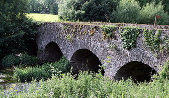
River Bann is a river in County Wexford
, in the southeast of Ireland
. It rises in the southern slopes of Croghan Mountain
in North Wexford on the County Wicklow
border. It flows south and is joined by the Blackwater Stream near the village of Hollyfort
. Veering southwest it passes under the R725
, then continuing southwestwards it flows beneath the N11 national primary route
at the village of Camolin
. It is crossed by the Dublin - Wexford
railway four times as it flows past the town of Ferns
before joining the River Slaney
north of Enniscorthy
.

County Wexford
County Wexford is a county in Ireland. It is part of the South-East Region and is also located in the province of Leinster. It is named after the town of Wexford. In pre-Norman times it was part of the Kingdom of Uí Cheinnselaig, whose capital was at Ferns. Wexford County Council is the local...
, in the southeast of Ireland
Ireland
Ireland is an island to the northwest of continental Europe. It is the third-largest island in Europe and the twentieth-largest island on Earth...
. It rises in the southern slopes of Croghan Mountain
Croghan Mountain
Croghan Kinsella is a mountain in the Wicklow Mountains, on the Wicklow/Wexford border.The Wexford 'River Bann' rises from its southern slopes.-External links:*...
in North Wexford on the County Wicklow
County Wicklow
County Wicklow is a county in Ireland. It is part of the Mid-East Region and is also located in the province of Leinster. It is named after the town of Wicklow, which derives from the Old Norse name Víkingalág or Wykynlo. Wicklow County Council is the local authority for the county...
border. It flows south and is joined by the Blackwater Stream near the village of Hollyfort
Hollyfort
Hollyfort is a village in north County Wexford, Ireland. It lies within the townland of Mongan in the valley of the River Bann, 5 km northwest of Gorey...
. Veering southwest it passes under the R725
R725 road
The R725 road is a regional road in Ireland. From its junction with the N80 on the western outskirts of Carlow Town it takes an easterly route to its junction with the N80 in Tullow, where it crosses the River Slaney on a bridge shared with the N80 in the town centre. It continues east to...
, then continuing southwestwards it flows beneath the N11 national primary route
Roads in Ireland
The island of Ireland, comprising Northern Ireland and the Republic of Ireland, has an extensive network of tens of thousands of kilometres of public roads, usually surfaced. These roads have been developed and modernised over centuries, from trackways suitable only for walkers and horses, to...
at the village of Camolin
Camolin, County Wexford
Camolin is a village in County Wexford in Ireland, situated in the valley of the River Bann on the N11 national primary route northeast of Ferns..-Transport:Camolin railway station opened on 1 November 1867, but finally closed on 30 March 1964....
. It is crossed by the Dublin - Wexford
Wexford
Wexford is the county town of County Wexford, Ireland. It is situated near the southeastern corner of Ireland, close to Rosslare Europort. The town is connected to Dublin via the M11/N11 National Primary Route, and the national rail network...
railway four times as it flows past the town of Ferns
Ferns, County Wexford
Ferns is a small historic town in north County Wexford, Ireland with a population of about 900. It is 16 km from Enniscorthy, where the Gorey to Enniscorthy N11 road joins the R745 regional road...
before joining the River Slaney
River Slaney
The Slaney is a river in the southeast of Ireland. It rises on Lugnaquilla Mountain in the western Wicklow Mountains and flows west and then south through counties Wicklow, Carlow and Wexford, before entering St George's Channel in the Irish Sea at Wexford town...
north of Enniscorthy
Enniscorthy
Enniscorthy is the second largest town in County Wexford, Ireland. The population of the town and environs is 9538. The Placenames Database of Ireland sheds no light on the origins of the town's name. It may refer either to the "Island of Corthaidh" or the "Island of Rocks". With a history going...
.

See also
Rivers of IrelandRivers of Ireland
The longest river in Ireland is the The longest river in [[Ireland]] is the The longest river in [[Ireland]] is the [[River Shannon, 386 km . The river develops into three lakes along its course, [[Lough Allen]], [[Lough Ree]] and [[Lough Derg |Lough Derg]]. Of these, Lough Derg is the...

