
.gif)
Rio de la Plata (Puerto Rico)
Encyclopedia
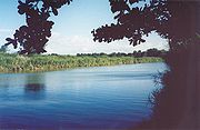
The Rio de la Plata is the longest river in the island of Puerto Rico
. It is located in the north coast of the island. It flows from south to north, and drains into the Atlantic Ocean
about 11 miles (18 km) west of San Juan
. The mouth of the river is a resort area with white sandy beaches.
La Plata has a length of approximately 60.5 miles (97 kilometers) with its origin in the municipality of Guayama, Puerto Rico
, at an altitude of approximately 2,625 feet (800 meters) above sea level. It crosses the municipalities of Guayama
, Cayey
, Comerío
, Naranjito
, Toa Alta
, Toa Baja
, and Dorado
forming two lakes on its path: Carite Lake
and La Plata Lake
.
There are many crossings of the river. The Arenas Bridge
, in Cayey, is one of the most notable. It is a steel bridge built in 1894 and is still in use. It was the longest bridge built in Puerto Rico by the Spanish.
The United States
Army Corps of Engineers
is undertaking a major flood
control project in the river basin.
 The Taíno
Indians referred to the river as "thoa" which means mother
, which itself gave the name to the towns of Toa Alta
and Toa Baja
located in the mouth of the river to the Atlantic Ocean
.
Puerto Rico
Puerto Rico , officially the Commonwealth of Puerto Rico , is an unincorporated territory of the United States, located in the northeastern Caribbean, east of the Dominican Republic and west of both the United States Virgin Islands and the British Virgin Islands.Puerto Rico comprises an...
. It is located in the north coast of the island. It flows from south to north, and drains into the Atlantic Ocean
Atlantic Ocean
The Atlantic Ocean is the second-largest of the world's oceanic divisions. With a total area of about , it covers approximately 20% of the Earth's surface and about 26% of its water surface area...
about 11 miles (18 km) west of San Juan
San Juan, Puerto Rico
San Juan , officially Municipio de la Ciudad Capital San Juan Bautista , is the capital and most populous municipality in Puerto Rico, an unincorporated territory of the United States. As of the 2010 census, it had a population of 395,326 making it the 46th-largest city under the jurisdiction of...
. The mouth of the river is a resort area with white sandy beaches.
La Plata has a length of approximately 60.5 miles (97 kilometers) with its origin in the municipality of Guayama, Puerto Rico
Guayama, Puerto Rico
Guayama is a municipality of Puerto Rico founded on January 29, 1736 and located on the Southern Coastal Valley region, bordering the Caribbean, south of Cayey; east of Salinas; and west of Patillas and Arroyo. Guayama is spread over 9 wards and Guayama Pueblo...
, at an altitude of approximately 2,625 feet (800 meters) above sea level. It crosses the municipalities of Guayama
Guayama, Puerto Rico
Guayama is a municipality of Puerto Rico founded on January 29, 1736 and located on the Southern Coastal Valley region, bordering the Caribbean, south of Cayey; east of Salinas; and west of Patillas and Arroyo. Guayama is spread over 9 wards and Guayama Pueblo...
, Cayey
Cayey, Puerto Rico
Cayey is a mountain town in central Puerto Rico located on the Central Mountain range, north of Salinas and Guayama; south of Cidra and Caguas; east of Aibonito and Salinas; and west of San Lorenzo Cayey is spread over 21 wards and Cayey Pueblo...
, Comerío
Comerío, Puerto Rico
Comerío is a municipality of Puerto Rico located in the center-eastern region of island, north of Aibonito; south of Naranjito and Bayamón; east of Barranquitas; and west of Cidra and Aguas Buenas. Comerío is spread over 7 wards and Comerío Pueblo...
, Naranjito
Naranjito, Puerto Rico
Naranjito is a municipality of Puerto Rico located in the central region of the island, south of Toa Alta; north of Barranquitas and Comerío; east of Corozal; and west of Bayamón. Naranjito is spread over 15 wards and Naranjito Pueblo...
, Toa Alta
Toa Alta, Puerto Rico
Toa Alta is a municipality of Puerto Rico located in the northern coast of the island, north of Naranjito; south of Dorado and Toa Baja; east of Vega Alta and Corozal; and west of Bayamón. Toa Alta is spread over eight wards and Toa Alta Pueblo...
, Toa Baja
Toa Baja, Puerto Rico
Toa Baja is a municipality of Puerto Rico located in the northern coast, north of Toa Alta and Bayamón; east of Dorado; and west of Cataño. Toa Baja is spread over 5 wards and Toa Baja Pueblo . It is part of the San Juan-Caguas-Guaynabo Metropolitan Statistical Area.Toa Baja considered to be a...
, and Dorado
Dorado, Puerto Rico
Dorado is a small tourist town in the northern coast of Puerto Rico, west of San Juan and is located in the northern region of the island, bordering the Atlantic Ocean, north of Toa Alta, east of Vega Alta, and west of Toa Baja. Dorado is spread over five barrios and Dorado Pueblo...
forming two lakes on its path: Carite Lake
Carite Lake
Lago Carite is a lake located in the municipality of Guayama on the island of Puerto Rico. The lake was created in 1913 and serves as a reservoir for irrigation, and potable water....
and La Plata Lake
La Plata Lake
Lago La Plata is a lake located between the municipalities of Naranjito, Toa Alta, and Bayamón in Puerto Rico. The lake was created in 1973 and serves as a reservoir for potable water.The lake receives flow from the La Plata River and can be used for fishing....
.
There are many crossings of the river. The Arenas Bridge
Arenas Bridge
The Arenas Bridge between the municipalities of Cayey and Cidra, is a truss bridge built in 1894. Also known as Puente Rio La Plata, it was the longest bridge constructed in Puerto Rico during the Spanish colonial period. It crosses the Rio de la Plata, the longest river in Puerto Rico. ...
, in Cayey, is one of the most notable. It is a steel bridge built in 1894 and is still in use. It was the longest bridge built in Puerto Rico by the Spanish.
The United States
United States
The United States of America is a federal constitutional republic comprising fifty states and a federal district...
Army Corps of Engineers
United States Army Corps of Engineers
The United States Army Corps of Engineers is a federal agency and a major Army command made up of some 38,000 civilian and military personnel, making it the world's largest public engineering, design and construction management agency...
is undertaking a major flood
Flood
A flood is an overflow of an expanse of water that submerges land. The EU Floods directive defines a flood as a temporary covering by water of land not normally covered by water...
control project in the river basin.
History
Taíno people
The Taínos were pre-Columbian inhabitants of the Bahamas, Greater Antilles, and the northern Lesser Antilles. It is thought that the seafaring Taínos are relatives of the Arawak people of South America...
Indians referred to the river as "thoa" which means mother
Mother
A mother, mum, mom, momma, or mama is a woman who has raised a child, given birth to a child, and/or supplied the ovum that grew into a child. Because of the complexity and differences of a mother's social, cultural, and religious definitions and roles, it is challenging to specify a universally...
, which itself gave the name to the towns of Toa Alta
Toa Alta, Puerto Rico
Toa Alta is a municipality of Puerto Rico located in the northern coast of the island, north of Naranjito; south of Dorado and Toa Baja; east of Vega Alta and Corozal; and west of Bayamón. Toa Alta is spread over eight wards and Toa Alta Pueblo...
and Toa Baja
Toa Baja, Puerto Rico
Toa Baja is a municipality of Puerto Rico located in the northern coast, north of Toa Alta and Bayamón; east of Dorado; and west of Cataño. Toa Baja is spread over 5 wards and Toa Baja Pueblo . It is part of the San Juan-Caguas-Guaynabo Metropolitan Statistical Area.Toa Baja considered to be a...
located in the mouth of the river to the Atlantic Ocean
Atlantic Ocean
The Atlantic Ocean is the second-largest of the world's oceanic divisions. With a total area of about , it covers approximately 20% of the Earth's surface and about 26% of its water surface area...
.