
Rio, Greece
Encyclopedia
Rio is a town and a former municipality
in Achaea
, West Greece, Greece
. Since the 2011 local government reform it is part of the municipality Patras
, of which it is a municipal unit. The former municipality had a population of around 13,000.
. Elevation is about 10 m downtown, and 20 to 50 m in its east. Many of the houses are lined up between the beach, the railway and the national road. A view of Aetoloacarnania (Acarnania
), northwestern Peloponnese
including Patras
and southwestern Phokis, along with the Panachaicus mountains surrounded with a scenery, and mountains are surrounded in its east. The boundary with the community of Aktaio was by the highway east of the town centre.
The municipality included Kastellokampos
in the south and Agios Georgios slightly south. The town center is inland near Somerset Street.
Hills and a mountain can be seen over the community's northeastern boundary.
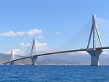
The town is covered with sandy beaches in the west with a scenic local beach road lengthening for about 6 km. In the middle, a fortress, and a harbor located northwest of downtown. The harbor offers ferry service to Antirrion which, for the past 50 years, has enabled traffic to flow between the Peloponnese and Western Mainland Greece. The traffic through the ferries is quite heavy, including a lot of trucks. The ferries already been replaced by the Rio-Antirio Bridge
. Not far from the port, a small oil refinery situated 800 m north and carries little production. Oil trucks are not allowed on the bridge and the ferry service is both regular and an economic alternative to the bridge.
Rio Beach includes Camping Rio Beach is its campground founded west of the centre. Its distances from Alissos is about 20 to 25 km.
The University of Patras
is in its east and is bounded by a river in the south and southeast and a hospital is founded there, and a toll.
Farmlands dominate the east and the west and used to dominate the southeastern part. Pastures and groves are common in the area. White Muscats are grown in this area and in Patras and wineries are also one of the main production of the local agriculture.
"ῥίον" (rhion), generally meaning "jutting part", perhaps from "ῥίς" (rhis), "nose", but also "spur of land". The earliest attested form of the word "ῥίον" (rhion) is the Mycenaean Greek ri-jo-no, from ri-jo, meaning "cape", written in Linear B
syllabic script.
Communities and Municipalities of Greece
For the new municipalities of Greece see the Kallikratis ProgrammeThe municipalities and communities of Greece are one of several levels of government within the organizational structure of that country. Thirteen regions called peripheries form the largest unit of government beneath the State. ...
in Achaea
Achaea
Achaea is one of the regional units of Greece. It is part of the region of West Greece. It is situated in the northwestern part of the Peloponnese peninsula. The capital is Patras. The population exceeds 300,000 since 2001.-Geography:...
, West Greece, Greece
Greece
Greece , officially the Hellenic Republic , and historically Hellas or the Republic of Greece in English, is a country in southeastern Europe....
. Since the 2011 local government reform it is part of the municipality Patras
Patras
Patras , ) is Greece's third largest urban area and the regional capital of West Greece, located in northern Peloponnese, 215 kilometers west of Athens...
, of which it is a municipal unit. The former municipality had a population of around 13,000.
Geography
The town center is about 7 km N of Patras by GR-8Greek National Road 8
The National Road 8 in Greece is a single carriageway with at-grade intersections in the Attica and Peloponnese regions. It links the cities of Patras, Corinth and Athens. Until the 1960s when the National Road 8A, a toll road, replaced it as a major route, it was the only road linking Athens and...
. Elevation is about 10 m downtown, and 20 to 50 m in its east. Many of the houses are lined up between the beach, the railway and the national road. A view of Aetoloacarnania (Acarnania
Acarnania
Acarnania is a region of west-central Greece that lies along the Ionian Sea, west of Aetolia, with the Achelous River for a boundary, and north of the gulf of Calydon, which is the entrance to the Gulf of Corinth. Today it forms the western part of the prefecture of Aetolia-Acarnania. The capital...
), northwestern Peloponnese
Peloponnese
The Peloponnese, Peloponnesos or Peloponnesus , is a large peninsula , located in a region of southern Greece, forming the part of the country south of the Gulf of Corinth...
including Patras
Patras
Patras , ) is Greece's third largest urban area and the regional capital of West Greece, located in northern Peloponnese, 215 kilometers west of Athens...
and southwestern Phokis, along with the Panachaicus mountains surrounded with a scenery, and mountains are surrounded in its east. The boundary with the community of Aktaio was by the highway east of the town centre.
The municipality included Kastellokampos
Kastellokampos
Kastellokampos is a beach town located 7 km north of the downtown core of Patras in Achaea, Greece. It is part of the municipal unit of Rio. The population is between 2,000 and 3,000. It is connected with the road connecting the GR-8/E55 and Proasteio and Rio, it also connects direct with the...
in the south and Agios Georgios slightly south. The town center is inland near Somerset Street.
Hills and a mountain can be seen over the community's northeastern boundary.
History
The community has existed for around 3,000 years (range), and has fought a couple of battles in 425 BC, and during medieval times.Infrastructure
Agriculture and farmland used to dominate the town of Rio until building rate increased. Gradually more houses were built, together with a hospital and a university, in the 1970s or the 1980s. Only half of the town is covered by farmlands today, and this percentage is shrinking.The town is covered with sandy beaches in the west with a scenic local beach road lengthening for about 6 km. In the middle, a fortress, and a harbor located northwest of downtown. The harbor offers ferry service to Antirrion which, for the past 50 years, has enabled traffic to flow between the Peloponnese and Western Mainland Greece. The traffic through the ferries is quite heavy, including a lot of trucks. The ferries already been replaced by the Rio-Antirio Bridge
Rio-Antirio bridge
The Rion-Antirion bridge , officially the Charilaos Trikoupis bridge after the statesman who first envisaged it, is the world's longest multi-span cable-stayed bridge...
. Not far from the port, a small oil refinery situated 800 m north and carries little production. Oil trucks are not allowed on the bridge and the ferry service is both regular and an economic alternative to the bridge.
Rio Beach includes Camping Rio Beach is its campground founded west of the centre. Its distances from Alissos is about 20 to 25 km.
The University of Patras
University of Patras
University of Patras is a university established in 1964 in Patras, Greece. Initially housed in the city centre, the university's campus is now located in the adjacent municipality of Rio...
is in its east and is bounded by a river in the south and southeast and a hospital is founded there, and a toll.
Farmlands dominate the east and the west and used to dominate the southeastern part. Pastures and groves are common in the area. White Muscats are grown in this area and in Patras and wineries are also one of the main production of the local agriculture.
Government
The mayors of the municipality were:- Vasileios Zervas (1998–2006)
- Christos Liakopoulos (2006–2010)
Etymology
The name Rio derives from the GreekGreek language
Greek is an independent branch of the Indo-European family of languages. Native to the southern Balkans, it has the longest documented history of any Indo-European language, spanning 34 centuries of written records. Its writing system has been the Greek alphabet for the majority of its history;...
"ῥίον" (rhion), generally meaning "jutting part", perhaps from "ῥίς" (rhis), "nose", but also "spur of land". The earliest attested form of the word "ῥίον" (rhion) is the Mycenaean Greek ri-jo-no, from ri-jo, meaning "cape", written in Linear B
Linear B
Linear B is a syllabic script that was used for writing Mycenaean Greek, an early form of Greek. It pre-dated the Greek alphabet by several centuries and seems to have died out with the fall of Mycenaean civilization...
syllabic script.
Subdivisions
The municipal unit Rio is subdivided into the following communities (constituent villages in brackets):- Agios Vasileios
- Aktaio
- Ano Kastritsi
- ArachovitikaArachovitikaArachovitika is a village located in the municipal unit of Rio in the northern part of Achaea, Greece. Cape Drepano is a trapezoidal cape facing the northwest and is the northernmost point in the Peloponnese and the prefecture of Achaia. The village is connected slightly northwest of the old GR-8...
(Arachovitika, Kato Arachovitika) - ArgyraArgyra, Greece-Nearest places:*Drepano, northwest*Sella, east*Ano Kastritsi, southwest*Platani, west-Population:-Location:Argyra is located 15 km east from Patras, 7 km from the GR-8/E65 , and the GR-5 with the GR-48 interchange, 9 km from the centre of Rio, and about 30 km west of...
- DrepanoDrepano, AchaeaDrepano, is a village in the municipality of Patras, Achaea, Greece. As of 2001, it had a population of 388 for the village and sits at 1,000 m above sea level...
- Kato Kastritsi (Kato Kastritsi, Magoula)
- PititsaPititsaPititsa is a village in the municipal unit of Rio, Achaea, Greece. As of 2001, it had a population of 86 for the village. The Volinaios River flows to east and the Panachaiko mountains are to the south...
- PlataniPlatani, AchaeaPlatani, is a village in the municipal unit of Rio, Achaia prefecture, Greece. As of 2001, it had a population of 460. The Volinaios River flows to east and the Panachaiko mountains are to the south...
- PsathopyrgosPsathopyrgosPsathopyrgos is a tourist village located in the municipal unit of Rio in the northern part of Achaea. It is the northernmost community in the Peloponnese. Psathopyrgos is located southeast of Cape Drepano, a trapezoidal cape facing the northwest and is the northernmost point in the Peloponnese...
(Psathopyrgos, Kato Rodini) - Rio
- SellaSella, GreeceSella is a village in the municipal unit of Rio, Achaea, Greece. As of 2001, it had a population of 388 and sits at 1,000 m above sea level. The Volinaios River flows to north and the Panachaiko mountains are to the south.-Nearest places:...
Historical population
| Year | Municipal district | Municipality |
|---|---|---|
| 1981 | 2,012 | - |
| 1991 | 3,496 | 10,280 |
| 2001 | - | 13,291 |