

Ring 2 (Oslo)
Encyclopedia
Ring road
A ring road, orbital motorway, beltway, circumferential highway, or loop highway is a road that encircles a town or city...
and surface street through densely populated parts of Oslo
Oslo
Oslo is a municipality, as well as the capital and most populous city in Norway. As a municipality , it was established on 1 January 1838. Founded around 1048 by King Harald III of Norway, the city was largely destroyed by fire in 1624. The city was moved under the reign of Denmark–Norway's King...
, Norway
Norway
Norway , officially the Kingdom of Norway, is a Nordic unitary constitutional monarchy whose territory comprises the western portion of the Scandinavian Peninsula, Jan Mayen, and the Arctic archipelago of Svalbard and Bouvet Island. Norway has a total area of and a population of about 4.9 million...
.
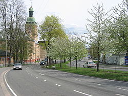
Geography
It stretches from SkøyenSkøyen
Skøyen is a neighborhood of Oslo, Norway. It is located in the western part of the city, in the borough of Ullern.The name "Skøyen" comes from Old Norse Skǫðin, of unknown etymology....
to Lodalen, a length of 9.7 km. The most important locations along the route are Skøyen
Skøyen
Skøyen is a neighborhood of Oslo, Norway. It is located in the western part of the city, in the borough of Ullern.The name "Skøyen" comes from Old Norse Skǫðin, of unknown etymology....
, Frogner
Frogner
Frogner is a borough of the city of Oslo, Norway. In addition to traditional Frogner, the borough incorporates Bygdøy, Uranienborg and Majorstuen....
, Majorstuen
Majorstuen
Majorstuen is a neighbourhood in the Frogner borough in the western part of Oslo, Norway.Majorstuen is known for its vibrant downtown, especially its shopping area. The area has several elegant townhouses circa 1880-1890. The area is also an important public transport junction in Oslo, where all...
, Lindern
Lindern
Lindern is a municipality in the district of Cloppenburg, in Lower Saxony, Germany. It is situated approx. 20 km west of Cloppenburg....
, Sagene
Sagene
Sagene is a borough of the city of Oslo, Norway. The area became part of the city of Oslo in 1859.The name Sagene itself is the plural of the Norwegian word for "saw", reflecting all the old industrial mechanical saws powered by the river Akerselvain this area in the 19th and early 20th...
, Carl Berners plass
Carl Berners plass
Carl Berners plass is a square in Oslo, Norway. It is located in the borough Grünerløkka, south of Sinsen. The Sinsen Line of the Oslo Tramway runs over the square. The colloquial expression for the square is just "Carl Berner". Around the square is a large number of shops as well as inexpensive...
, Tøyen
Tøyen
Tøyen is a residential area in the central parts of Oslo, Norway, part of the borough of Gamle Oslo.-Location:It is noted for its high concentration of immigrants. The multicultural atmosphere makes Tøyen very trendy and popular with continually rising cost of housing.There are two different...
and Galgeberg
Galgeberg
Galgeberg is a neighbourhood in the borough of Gamle Oslo in Oslo, Norway.The neighbourhood lies near Vålerenga, Kampen and Gamlebyen. The name stems from the gallows present at the location in earlier times.-References:...
. Important institutions like the Frogner Park
Frogner Park
Frogner Park is a public park located in the borough of Frogner in Oslo, Norway. The park contains the world famous Vigeland Sculpture Park designed by Gustav Vigeland....
, the Norwegian Broadcasting Corporation, Ullevål University Hospital
Ullevål University Hospital
Ullevaal, Oslo University Hospital was opened in 1887. From January 1, 2009, the hospital is part of the Oslo University Hospital.Ullevål has more than 8,600 employees. 940 of them are doctors and 2,400 nurses. With a total of 1,200 beds Ullevål, admits some 45,000 patients per year and its...
and the University of Oslo
University of Oslo
The University of Oslo , formerly The Royal Frederick University , is the oldest and largest university in Norway, situated in the Norwegian capital of Oslo. The university was founded in 1811 and was modelled after the recently established University of Berlin...
are situated along or near the road. The name of streets are Drammensveien—Halvdan Svartes gate—Kirkeveien—Griffenfeldts gate—Marcus Thranes gate—Christian Michelsens gate—Finnmarkgaten—Kjølberggaten—Åkebergveien—St. Halvards gate—Kværnerveien.
Traffic
Ring 2 is used by both cars and public transportation. The traffic on the route is separated only with traffic lightTraffic light
Traffic lights, which may also be known as stoplights, traffic lamps, traffic signals, signal lights, robots or semaphore, are signalling devices positioned at road intersections, pedestrian crossings and other locations to control competing flows of traffic...
s and roundabouts. The road is connected to major highways such as European route E18
European route E18
European route E18 runs from Craigavon in the United Kingdom to Saint Petersburg in Russia, passing through Norway, Sweden, and Finland. It is about 1,890 km in length.-United Kingdom:...
, National Road 4
Norwegian National Road 4
Riksvei 4 is a national road which is the main route north from Oslo, Norway. The road runs through Nittedal, Hadeland and Toten to Mjøsa....
and National Road 190. Major parts of Ring 2 are heavily congested during peak hours, because of low capacity and many large intersections. The route was originally planned to have 4 lanes, but several parts have only 2 lanes. The entire route is a priority road and the speed limit is 50 km/h.
There are some parking garages situated on the western parts of the route. The gas stations along the road are situated on Skøyen, Marienlyst, Fagerborg, Lindern, Carl Berners Plass and Tøyen.