

Remote Sensing Center
Encyclopedia
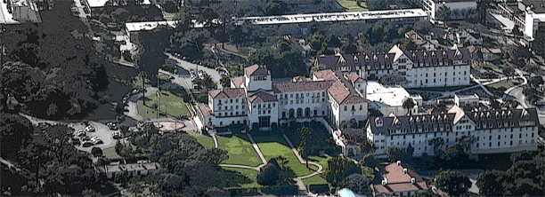
The Remote Sensing Center (RSC) at the Naval Postgraduate School
was established to bring together a range of capabilities and expertise to address problems of military and intelligence importance, as well as environmental and civil concerns. It is specialized in a variety of remote sensing
technologies designed to enable people to look beyond the range of human vision in range or in spectral perception.
, electrical and computer engineering, computer science, meteorology
, and oceanography
departments. They are collaborating to develop new remote sensing systems, as well as use and exploit current systems in air and space. It is part of a larger activity in the Monterey Bay
area that provides expertise in topical areas outside the technical disciplines available at NPS.
The Naval Postgraduate School, and specifically the Remote Sensing Center, has the ability to handle classified data, as well as access to a Sensitive Compartmented Information Facility (SCIF) that is fully equipped with comms, storage, and processing capabilities. The RSC has pre-established cooperative research with government, academia, and industry in the remote sensing sector ranging from local to international partners. Highly experienced military officers, intelligence analysts, and faculty are a critical part of the NPS research staff.
(Light Detection and Ranging) works as an optical analog to radar
in the visible spectrum of light with advantages related to the smaller wavelengths of the laser pulse. LiDAR ranges in wavelength from ultra-violet (0.3-0.45 µm) to visible (0.45-0.70 µm) to the infrared (1-15 µm). LiDAR can detect much smaller particles than radar in the atmosphere (which cannot detect things smaller than cloud particles), and thus can be used for aerosol detection.
The raw form of data is a set of x,y,z coordinate points. With recent advances, resolution has improved dramatically. Raw data can be processed to remove unwanted areas or features. Outputs such as topographic maps with contour lines can also be derived from LiDAR. Programs to manipulate LiDAR data include ENVI, ERDAS IMAGINE
, ArcInfo
, and ESRI
ArcView (with 3D analyst ext.) One useful derivation of LiDAR data is the DEM (Digital Elevation Model
). DEMs are displayed in a raster format with a matrix. The DEM has a specified cell size that corresponds to the earth’s surfaces. The cell contains the average elevation of the points within it.
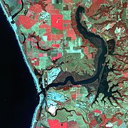
The Remote Sensing Center is planning research projects that undertake the modeling and testing of analytical processing and using more fieldwork to obtain ground-truth measurements. Projects have been completed and are currently underway in terrain classification including Elkhorn Slough
and hidden trail identification. Other future projects include a collaboration with the MOdeling, Virtual Environments, and Simulation (MOVES) institute on LiDAR standards for data structure and visualization tools and modeling new LiDAR analysis tools.
 Spectral imagery measures the spectral character of materials within the visible range and beyond. Two objects may appear visually identical but may be distinguished through examination of their spectral properties. Computer software can use a color scheme to make them visible.
A subset of spectral imagery, hyperspectral imaging
data, is produced when "solar electromagnetic energy reflected from the earth's surface is dispersed into many contiguous narrow spectral bands by an airborne spectrometer" (Stefanou, 1997, p. 2). Our current research and projects include environmental mapping, target detection, and change detection.
The Remote Sensing Center works with airborne and satellite systems including IKONOS
/Quickbird
multispectral imagery (MSI), and airborne hyperspectral imaging (HSI) systems including AVIRIS, HYDICE, CASI, and HYMAP. Classification and analysis, including atmospheric compensation is performed using standard industry research tools; notably ENVI and ERDAS Imagine. The RSC has acquired a polarimetric
camera for expanding experimentation in the visible spectrum.
The sustained efforts of fully funded graduate students, both military and civilian with an average of eight to ten years of field experience, have conducted research in an array of topics related to remote sensing.
Classified Education and Research
One of the unique benefits of education opportunities at the Naval Postgraduate School is the access to classified data and information, as well as the ability to produce classified theses. NPS sets the bar for classified intelligence research and academic excellence in a secure environment. NPS is fully equipped with a SCIF, a Classified Library, and many faculty members cleared to the Top Secret (SCI) level; commodities unavailable at most civilian universities.
Curriculum and Program Description
The curriculum course matrix was approved by the NPS Academic Council New Curriculum Committee in January 2009.
The curriculum is designed to be modular with three elements of interdisciplinary study: foundation technical skills, Remote Sensing technology and techniques, and intelligence applications. Several of the courses are taught at the TS (SCI) level. Current clearance is not required for admission, however an active TS (SCI) clearance must be obtained by the time coursework is started as there is not time to complete the process once classes have begun. Ideally students are involved in research requested and funded by their sponsoring agency to ensure that the research products from the program are relevant, viable and timely.
The degree lasts for 12 months (4 quarters) and includes thesis research. All students are required to complete a thesis for graduation (IAW with their sponsoring agency's research needs).
Sponsorship
The Remote Sensing Center is looking to expand interest in Remote Sensing education throughout the RS product stakeholders within the government, military and intelligence communities. Agencies interested in sending their employees (or hiring employees via the Scholarship for Service programs) are encouraged to contact us to discuss their education needs.
Naval Postgraduate School
The Naval Postgraduate School is an accredited research university operated by the United States Navy. Located in Monterey, California, it grants master's degrees, Engineer's degrees and doctoral degrees...
was established to bring together a range of capabilities and expertise to address problems of military and intelligence importance, as well as environmental and civil concerns. It is specialized in a variety of remote sensing
Remote sensing
Remote sensing is the acquisition of information about an object or phenomenon, without making physical contact with the object. In modern usage, the term generally refers to the use of aerial sensor technologies to detect and classify objects on Earth by means of propagated signals Remote sensing...
technologies designed to enable people to look beyond the range of human vision in range or in spectral perception.
Mission
Members of the RSC come from the physicsPhysics
Physics is a natural science that involves the study of matter and its motion through spacetime, along with related concepts such as energy and force. More broadly, it is the general analysis of nature, conducted in order to understand how the universe behaves.Physics is one of the oldest academic...
, electrical and computer engineering, computer science, meteorology
Meteorology
Meteorology is the interdisciplinary scientific study of the atmosphere. Studies in the field stretch back millennia, though significant progress in meteorology did not occur until the 18th century. The 19th century saw breakthroughs occur after observing networks developed across several countries...
, and oceanography
Oceanography
Oceanography , also called oceanology or marine science, is the branch of Earth science that studies the ocean...
departments. They are collaborating to develop new remote sensing systems, as well as use and exploit current systems in air and space. It is part of a larger activity in the Monterey Bay
Monterey Bay
Monterey Bay is a bay of the Pacific Ocean, along the central coast of California. The bay is south of San Francisco and San Jose, between the cities of Santa Cruz and Monterey....
area that provides expertise in topical areas outside the technical disciplines available at NPS.
The Naval Postgraduate School, and specifically the Remote Sensing Center, has the ability to handle classified data, as well as access to a Sensitive Compartmented Information Facility (SCIF) that is fully equipped with comms, storage, and processing capabilities. The RSC has pre-established cooperative research with government, academia, and industry in the remote sensing sector ranging from local to international partners. Highly experienced military officers, intelligence analysts, and faculty are a critical part of the NPS research staff.
LiDAR
LiDARLIDAR
LIDAR is an optical remote sensing technology that can measure the distance to, or other properties of a target by illuminating the target with light, often using pulses from a laser...
(Light Detection and Ranging) works as an optical analog to radar
Radar
Radar is an object-detection system which uses radio waves to determine the range, altitude, direction, or speed of objects. It can be used to detect aircraft, ships, spacecraft, guided missiles, motor vehicles, weather formations, and terrain. The radar dish or antenna transmits pulses of radio...
in the visible spectrum of light with advantages related to the smaller wavelengths of the laser pulse. LiDAR ranges in wavelength from ultra-violet (0.3-0.45 µm) to visible (0.45-0.70 µm) to the infrared (1-15 µm). LiDAR can detect much smaller particles than radar in the atmosphere (which cannot detect things smaller than cloud particles), and thus can be used for aerosol detection.
The raw form of data is a set of x,y,z coordinate points. With recent advances, resolution has improved dramatically. Raw data can be processed to remove unwanted areas or features. Outputs such as topographic maps with contour lines can also be derived from LiDAR. Programs to manipulate LiDAR data include ENVI, ERDAS IMAGINE
ERDAS IMAGINE
ERDAS IMAGINE is a remote sensing application with raster graphics editor capabilities designed by ERDAS for geospatial applications. The latest version is 2010, version 10.1. ERDAS IMAGINE is aimed primarily at geospatial raster data processing and allows the user to prepare, display and enhance...
, ArcInfo
ArcInfo
ArcInfo is a full-featured geographic information system produced by Esri, and is the highest level of licensing in the ArcGIS Desktop product line. It was originally a command-line based system...
, and ESRI
ESRI
Esri is a software development and services company providing Geographic Information System software and geodatabase management applications. The headquarters of Esri is in Redlands, California....
ArcView (with 3D analyst ext.) One useful derivation of LiDAR data is the DEM (Digital Elevation Model
Digital elevation model
A digital elevation model is a digital model or 3-D representation of a terrain's surface — commonly for a planet , moon, or asteroid — created from terrain elevation data....
). DEMs are displayed in a raster format with a matrix. The DEM has a specified cell size that corresponds to the earth’s surfaces. The cell contains the average elevation of the points within it.
The Remote Sensing Center is planning research projects that undertake the modeling and testing of analytical processing and using more fieldwork to obtain ground-truth measurements. Projects have been completed and are currently underway in terrain classification including Elkhorn Slough
Elkhorn Slough
Elkhorn Slough is a tidal slough and estuary on Monterey Bay in Monterey County, California. The community of Moss Landing and the huge Moss Landing Power Plant are located at the mouth of the slough on the bay....
and hidden trail identification. Other future projects include a collaboration with the MOdeling, Virtual Environments, and Simulation (MOVES) institute on LiDAR standards for data structure and visualization tools and modeling new LiDAR analysis tools.
Spectral Imagery Analysis
A subset of spectral imagery, hyperspectral imaging
Hyperspectral imaging
Hyperspectral imaging collects and processes information from across the electromagnetic spectrum. Much as the human eye sees visible light in three bands , spectral imaging divides the spectrum into many more bands...
data, is produced when "solar electromagnetic energy reflected from the earth's surface is dispersed into many contiguous narrow spectral bands by an airborne spectrometer" (Stefanou, 1997, p. 2). Our current research and projects include environmental mapping, target detection, and change detection.
The Remote Sensing Center works with airborne and satellite systems including IKONOS
IKONOS
IKONOS is a commercial earth observation satellite, and was the first to collect publicly available high-resolution imagery at 1- and 4-meter resolution. It offers multispectral and panchromatic imagery. The IKONOS launch was called by John E. Pike “one of the most significant developments in...
/Quickbird
QuickBird
QuickBird is a high-resolution commercial earth observation satellite, owned by DigitalGlobe and launched in 2001 as the first satellite in a constellation of three scheduled to be in orbit by 2008...
multispectral imagery (MSI), and airborne hyperspectral imaging (HSI) systems including AVIRIS, HYDICE, CASI, and HYMAP. Classification and analysis, including atmospheric compensation is performed using standard industry research tools; notably ENVI and ERDAS Imagine. The RSC has acquired a polarimetric
Polarimetry
Polarimetry is the measurement and interpretation of the polarization of transverse waves, most notably electromagnetic waves, such as radio or light waves...
camera for expanding experimentation in the visible spectrum.
Intelligence
The Remote Sensing Center benefits from the secure facilities at NPS. Having the ability to process classified data with an on-site, fully equipped Sensitive Compartmented Information Facility (SCIF) allows students and faculty to pursue lines of research and work with technologies unavailable to the public.The sustained efforts of fully funded graduate students, both military and civilian with an average of eight to ten years of field experience, have conducted research in an array of topics related to remote sensing.
- Current projects include:
- Helicopter Brownout (terrain classification) using National Technical Means (NTM)
- Maritime Domain Awareness (ASW)
- Snow/Ice study with UCSB using NTM
Degree Programs
The Remote Sensing Research and Education Program (RS-REP) is an interdisciplinary program to promote Remote Sensing technical education and research advancement to ensure that the Intelligence Community is fully supported for technology evolution. The combined agency program is sponsored by the National Geospatial-Intelligence Agency in support of its Image Analysts.Classified Education and Research
One of the unique benefits of education opportunities at the Naval Postgraduate School is the access to classified data and information, as well as the ability to produce classified theses. NPS sets the bar for classified intelligence research and academic excellence in a secure environment. NPS is fully equipped with a SCIF, a Classified Library, and many faculty members cleared to the Top Secret (SCI) level; commodities unavailable at most civilian universities.
Curriculum and Program Description
The curriculum course matrix was approved by the NPS Academic Council New Curriculum Committee in January 2009.
The curriculum is designed to be modular with three elements of interdisciplinary study: foundation technical skills, Remote Sensing technology and techniques, and intelligence applications. Several of the courses are taught at the TS (SCI) level. Current clearance is not required for admission, however an active TS (SCI) clearance must be obtained by the time coursework is started as there is not time to complete the process once classes have begun. Ideally students are involved in research requested and funded by their sponsoring agency to ensure that the research products from the program are relevant, viable and timely.
The degree lasts for 12 months (4 quarters) and includes thesis research. All students are required to complete a thesis for graduation (IAW with their sponsoring agency's research needs).
Sponsorship
The Remote Sensing Center is looking to expand interest in Remote Sensing education throughout the RS product stakeholders within the government, military and intelligence communities. Agencies interested in sending their employees (or hiring employees via the Scholarship for Service programs) are encouraged to contact us to discuss their education needs.
Partners
- University Partners
- University of California at Santa BarbaraUniversity of California, Santa BarbaraThe University of California, Santa Barbara, commonly known as UCSB or UC Santa Barbara, is a public research university and one of the 10 general campuses of the University of California system. The main campus is located on a site in Goleta, California, from Santa Barbara and northwest of Los...
(http://www.ucsb.edu/) - University of California at Santa CruzUniversity of California, Santa CruzThe University of California, Santa Cruz, also known as UC Santa Cruz or UCSC, is a public, collegiate university; one of ten campuses in the University of California...
(http://www.ucsc.edu/public/) - California State University at Monterey BayCalifornia State University, Monterey BayCalifornia State University, Monterey Bay is a small public university in the California State University system on the site of the former U.S. Army base Fort Ord, on the Central Coast of California. It is accredited by the Western Association of Schools and Colleges.CSUMB was founded in 1994 with...
(http://csumb.edu/)- Community Science Partners
- Elkhorn Slough Foundation (http://www.elkhornslough.org/)
- Moss Landing Marine Laboratory (http://www.mlml.calstate.edu/)
- Stanford’s Hopkins Marine Institute (http://www-marine.stanford.edu/)
- Monterey Bay Aquarium Research InstituteMonterey Bay Aquarium Research InstituteThe Monterey Bay Aquarium Research Institute is a not-for-profit oceanographic research center in Moss Landing, California affiliated with the Monterey Bay Aquarium. It was founded in 1987 by David Packard of Hewlett-Packard fame...
(http://www.mbari.org/) - Fleet Numerical Meteorology and Oceanography CenterFleet Numerical Meteorology and Oceanography CenterThe Fleet Numerical Meteorology and Oceanography Center , known prior to 1995 as the Fleet Numerical Oceanography Center , is a meteorological and oceanographic center located in Monterey, California...
(https://www.fnmoc.navy.mil/public/) - National Laboratories
- Lawrence Livermore National LaboratoryLawrence Livermore National LaboratoryThe Lawrence Livermore National Laboratory , just outside Livermore, California, is a Federally Funded Research and Development Center founded by the University of California in 1952...
(https://www.llnl.gov/) - Argonne National LaboratoryArgonne National LaboratoryArgonne National Laboratory is the first science and engineering research national laboratory in the United States, receiving this designation on July 1, 1946. It is the largest national laboratory by size and scope in the Midwest...
(http://www.anl.gov/)- Government Agencies
- National Oceanic and Atmospheric AdministrationNational Oceanic and Atmospheric AdministrationThe National Oceanic and Atmospheric Administration , pronounced , like "noah", is a scientific agency within the United States Department of Commerce focused on the conditions of the oceans and the atmosphere...
(http://www.noaa.gov/) - United States Geological SurveyUnited States Geological SurveyThe United States Geological Survey is a scientific agency of the United States government. The scientists of the USGS study the landscape of the United States, its natural resources, and the natural hazards that threaten it. The organization has four major science disciplines, concerning biology,...
(http://www.usgs.gov/) - United States Naval Research LaboratoryUnited States Naval Research LaboratoryThe United States Naval Research Laboratory is the corporate research laboratory for the United States Navy and the United States Marine Corps and conducts a program of scientific research and development. NRL opened in 1923 at the instigation of Thomas Edison...
(http://www.nrl.navy.mil/) - DIA Advanced RADAR Center
- National Geospatial-Intelligence AgencyNational Geospatial-Intelligence AgencyThe National Geospatial-Intelligence Agency is an agency of the federal government of the United States with the primary mission of collecting, analyzing and distributing geospatial intelligence in support of national security. NGA was formerly known as the National Imagery and Mapping Agency ...
(NGA) (http://www1.nga.mil/Pages/Default.aspx) - National Reconnaissance OfficeNational Reconnaissance OfficeThe National Reconnaissance Office , located in Chantilly, Virginia, is one of the 16 U.S. intelligence agencies. It designs, builds, and operates the spy satellites of the United States government.-Mission:...
(NRO) (http://www.nro.gov/)
Members
- Faculty and Staff
- Dr. Richard Christopher Olsen: Executive Director, Professor in the Physics Department (http://www.nps.edu/faculty/olsen/index.html)
- Dr. Philip A. Durkee: Associate Director, Chair of the Meteorology Department
- Mrs. Angie Kim: Technical Projects Director
- Ms. Jean Ferreira: Operations Manager
- Mr. David Trask: NPS MASINT Chair (Colonel, USAF ret.)
- Ms. Karen Andersen: Program Manager
-
- Research Associates: Mr. Chad Brodel, Ms. Krista Lee, Ms. Chelsea Esterline
-
- Research Assistants: Ms. Sarah Carlisle
- Affiliated Faculty
- Dr. Brett Borden
- Dr. Jeffrey Paduan (http://www.oc.nps.edu/~paduan/)
- Dr. Mathias Kolsch (http://www.movesinstitute.org/~kolsch/)