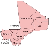
Regions of Mali
Encyclopedia
|
|
Mali
is divided into eight region
s and one capital district
. Each of the regions bears the name of its principal city. The regions are divided into 49 cercles
. The cercles and the capital district are divided into 703 communes
.
The regions are numbered, originally west to east, with Roman numerals
. The capital Bamako
is administered separately and is in its own District.
The eight regions and the Bamako District are listed below. The population figures are from the 2009 census.
|
Mali
Mali
Mali , officially the Republic of Mali , is a landlocked country in Western Africa. Mali borders Algeria on the north, Niger on the east, Burkina Faso and the Côte d'Ivoire on the south, Guinea on the south-west, and Senegal and Mauritania on the west. Its size is just over 1,240,000 km² with...
is divided into eight region
Region
Region is most commonly found as a term used in terrestrial and astrophysics sciences also an area, notably among the different sub-disciplines of geography, studied by regional geographers. Regions consist of subregions that contain clusters of like areas that are distinctive by their uniformity...
s and one capital district
District
Districts are a type of administrative division, in some countries managed by a local government. They vary greatly in size, spanning entire regions or counties, several municipalities, or subdivisions of municipalities.-Austria:...
. Each of the regions bears the name of its principal city. The regions are divided into 49 cercles
Cercles of Mali
A cercle is the second level administrative unit in Mali. Mali is divided into eight regions and one capital district . These subdivisions bear the name of their principal city. The regions are divided into 49 cercles....
. The cercles and the capital district are divided into 703 communes
Communes of Mali
A Commune is the third level administrative unit in Mali. Mali is divided into eight regions and one capital district . These subdivisions bear the name of their principal city. The regions are divided into 49 Cercles...
.
The regions are numbered, originally west to east, with Roman numerals
Roman numerals
The numeral system of ancient Rome, or Roman numerals, uses combinations of letters from the Latin alphabet to signify values. The numbers 1 to 10 can be expressed in Roman numerals as:...
. The capital Bamako
Bamako
Bamako is the capital of Mali and its largest city with a population of 1.8 million . Currently, it is estimated to be the fastest growing city in Africa and sixth fastest in the world...
is administered separately and is in its own District.
The eight regions and the Bamako District are listed below. The population figures are from the 2009 census.
| Region name | Region number | Area (km2) | Population |
|---|---|---|---|
| Gao Gao Region The Gao Region is located in eastern Mali. The region's capital city is Gao. Gao Region is bordered to the south and east by Niger, to the north by Kidal Region, and to the west by Tombouctou Region. Common ethnicities in the Gao Region include the Songhai, Bozo, Tuareg, Bambara, and Kounta... |
Région VII | 170,572 | 544,120 |
| Kayes Kayes Region Kayes Region is one of eight first level national subdivisions, called Regions in Mali. It is the first administrative area of Mali and covers an area of 120,760 km²... |
Région I | 120,760 | 1,996,812 |
| Kidal Kidal Region Kidal is the eighth administrative region of Mali, covering 151,430 km². Its capital is the city of Kidal.-Geography:The region is bordered on the west by Tomboctou Region, to the south by Gao Region, to the east by Niger and to the north by Algeria.... |
Région VIII | 151,430 | 67,638 |
| Koulikoro Koulikoro Region Koulikoro is a region in Mali. It is the second administrative area of Mali and covers an area of 90,120 km². Its capital is the city of Koulikoro.- Geography :... |
Région II | 90,120 | 2,418,305 |
| Mopti Mopti Region Mopti is the fifth administrative region of Mali, covering 79,017 km². Its capital is the city of Mopti.-Geography:Mopti Region is bordered by Tombouctou Region to the north, Ségou Region to the southwest, and Burkina Faso to the southeast.... |
Région V | 79,017 | 2,037,330 |
| Ségou Ségou Region Ségou is the fourth most populous administrative region in Mali, whose capital is the town of Ségou.-Geography:Situated at the center of Mali, Ségou Region covers 64,947 km²... |
Région IV | 64,947 | 2,336,255 |
| Sikasso Sikasso Region Sikasso is the southern-most region of Mali. The capital city of the same name is the 3rd-largest city and is growing rapidly due to people fleeing the violence in Côte d'Ivoire to the south. Major ethnic groups include the Senoufo, known for masks and reverence for animals, the Samago, known for... |
Région III | 71,790 | 2,625,919 |
| Tombouctou | Région VI | 497,926 | 681,691 |
| Bamako Bamako Bamako is the capital of Mali and its largest city with a population of 1.8 million . Currently, it is estimated to be the fastest growing city in Africa and sixth fastest in the world... |
Unnumbered | 252 | 1,809,106 |
See also
- Cercles of MaliCercles of MaliA cercle is the second level administrative unit in Mali. Mali is divided into eight regions and one capital district . These subdivisions bear the name of their principal city. The regions are divided into 49 cercles....
- ISO 3166-2:MLISO 3166-2:MLISO 3166-2:ML is the entry for Mali in ISO 3166-2, part of the ISO 3166 standard published by the International Organization for Standardization , which defines codes for the names of the principal subdivisions of all countries coded in ISO 3166-1.Currently for Mali, ISO 3166-2 codes are defined...

