
Regional District of Comox-Strathcona, British Columbia
Encyclopedia
The Regional District of Comox-Strathcona was a regional district
of British Columbia
, Canada
from 1967 to 2008. On February 15, 2008, the regional district was abolished and replaced by two successor regional districts, Comox Valley
and Strathcona
.
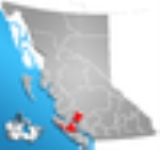
The district covered large portions of northern Vancouver Island
and included part of the mainland north of the Sunshine Coast. As of the 2006 Census
, the Regional District had a population of 101,595. The district's administrative offices were located in Courtenay
, although the most populous incorporated community was the District Municipality of Campbell River
.
and the Denman and Hornby
Islands on its east coast, and between Nootka Island
and the Brooks Peninsula on its west coast, including most of Strathcona Provincial Park
. The mainland portion, which is only very lightly settled, begins in the southeast at Toba Inlet
, and stretches northwest almost to the Knight Inlet
and also encompasses the Discovery Islands
. The total land area is 20,013.48 km² (7,728.01 sq mi).
Comox-Strathcona was bordered to the northwest by the Mount Waddington Regional District, to the east by the Powell River Regional District
, and to the south by the Alberni-Clayoquot
and Nanaimo
Regional Districts.
, BC Minister of Community Services, announced that it was to be split into two districts, one covering the Comox Valley (electoral areas A, B, C and K), the other covering the rest of the existing district. The announcement came as something of a surprise to the existing regional council, and was opposed by some, particularly those directors representing rural areas.
Regional districts of British Columbia
The Canadian province of British Columbia is divided into regional districts. Like counties in other parts of Canada, regional districts serve only to provide municipal services as the local government in areas not incorporated into a municipality, and in certain regional affairs of shared concern...
of British Columbia
British Columbia
British Columbia is the westernmost of Canada's provinces and is known for its natural beauty, as reflected in its Latin motto, Splendor sine occasu . Its name was chosen by Queen Victoria in 1858...
, Canada
Canada
Canada is a North American country consisting of ten provinces and three territories. Located in the northern part of the continent, it extends from the Atlantic Ocean in the east to the Pacific Ocean in the west, and northward into the Arctic Ocean...
from 1967 to 2008. On February 15, 2008, the regional district was abolished and replaced by two successor regional districts, Comox Valley
Comox Valley Regional District, British Columbia
The Comox Valley Regional District is a regional district in British Columbia, Canada. It was created on February 15, 2008, encompassing the southeastern portions of the former Regional District of Comox-Strathcona, and centered about the Comox Valley...
and Strathcona
Strathcona Regional District, British Columbia
The Strathcona Regional District is a regional district in British Columbia, Canada. It was created on February 15, 2008, encompassing the northern and western portions of the former Regional District of Comox-Strathcona. The partition left the new Strathcona Regional District with 91.6 percent of...
.
The district covered large portions of northern Vancouver Island
Vancouver Island
Vancouver Island is a large island in British Columbia, Canada. It is one of several North American locations named after George Vancouver, the British Royal Navy officer who explored the Pacific Northwest coast of North America between 1791 and 1794...
and included part of the mainland north of the Sunshine Coast. As of the 2006 Census
Canada 2006 Census
The Canada 2006 Census was a detailed enumeration of the Canadian population. Census day was May 16, 2006. The next census following will be the 2011 Census. Canada's total population enumerated by the 2006 census was 31,612,897...
, the Regional District had a population of 101,595. The district's administrative offices were located in Courtenay
Courtenay, British Columbia
Courtenay is a city on the east coast of Vancouver Island, in the Canadian province of British Columbia. It is the largest city in the area commonly known as the Comox Valley, and it is the seat of the Comox Valley Regional District which replaced the Comox-Strathcona Regional District...
, although the most populous incorporated community was the District Municipality of Campbell River
Campbell River, British Columbia
Campbell River is a coastal city in British Columbia on the east coast of Vancouver Island at the south end of Discovery Passage, which lies along the important coastal Inside Passage shipping route...
.
Geography
The Vancouver Island part of the Comox Strathcona Regional District stretches all the way across the island from east to west, and north to south between SaywardSayward, British Columbia
Sayward is a village located on in the Sayward Valley on the northeast coast of Vancouver Island in British Columbia, Canada. It is located about 1 mi inland from Kelsey Bay on a spur from Highway 19. The village is named after William Parsons Sayward, a successful lumber merchant from Victoria...
and the Denman and Hornby
Hornby Island
Hornby Island of British Columbia, Canada, is a Northern Gulf Island parallel with Vancouver Island's Comox Valley.A small community of 1,074 residents is distributed across the island. The island is culturally distinctive as it was the site of a large immigration of American draft dodgers during...
Islands on its east coast, and between Nootka Island
Nootka Island
Nootka Island is an island near Vancouver Island in British Columbia, Canada. It contains 534 km² of area. It is separated from Vancouver Island by Nootka Sound and its side-inlets....
and the Brooks Peninsula on its west coast, including most of Strathcona Provincial Park
Strathcona Provincial Park
Strathcona Provincial Park is the oldest provincial park in British Columbia, Canada, and the largest on Vancouver Island. Founded in 1911, the park was named for Donald Alexander Smith, 1st Baron Strathcona and Mount Royal, a wealthy philanthropist and railroad pioneer. It lies within the...
. The mainland portion, which is only very lightly settled, begins in the southeast at Toba Inlet
Toba Inlet
Toba Inlet is one of the lesser, but still principal, inlets of the British Columbia Coast. It is fourth in the series north from the 49th parallel which begins with Burrard Inlet, which is the harbour for the city of Vancouver...
, and stretches northwest almost to the Knight Inlet
Knight Inlet
Knight Inlet is one of the principal inlets of the British Columbia Coast, and the largest of the major inlets in the southern part of the Coast...
and also encompasses the Discovery Islands
Discovery Islands
The Discovery Islands are the islands in the Discovery Passage between Vancouver Island and the mainland in British Columbia. These islands are sometimes considered to be part of the Northern Gulf Islands....
. The total land area is 20,013.48 km² (7,728.01 sq mi).
Comox-Strathcona was bordered to the northwest by the Mount Waddington Regional District, to the east by the Powell River Regional District
Powell River Regional District, British Columbia
The Regional District of Powell River is a regional district in the Canadian province of British Columbia. It includes the City of Powell River and a number of unincorporated areas...
, and to the south by the Alberni-Clayoquot
Alberni-Clayoquot Regional District, British Columbia
The Alberni-Clayoquot Regional District of British Columbia is located on west central Vancouver Island. Adjacent regional districts it shares borders with are the Strathcona and Comox Valley Regional Districts to the north, and the Nanaimo and Cowichan Valley Regional Districts to the east...
and Nanaimo
Regional District of Nanaimo, British Columbia
The Regional District of Nanaimo is a regional district located on the eastern coast of Vancouver Island, British Columbia, Canada. It is bordered to the south by the Cowichan Valley Regional District, to the west by the Alberni-Clayoquot Regional District, and to the northwest by the Comox Valley...
Regional Districts.
History
In 2007, Ida ChongIda Chong
Ida Chong is British Columbia's Minister of Community, Sport and Cultural Development and was Minister Responsible for the Asia-Pacific Initiative as well as Minister of Technology, Trade, and Economic Development. She has served in this position since June 2008...
, BC Minister of Community Services, announced that it was to be split into two districts, one covering the Comox Valley (electoral areas A, B, C and K), the other covering the rest of the existing district. The announcement came as something of a surprise to the existing regional council, and was opposed by some, particularly those directors representing rural areas.
Incorporated communities
- Campbell RiverCampbell River, British ColumbiaCampbell River is a coastal city in British Columbia on the east coast of Vancouver Island at the south end of Discovery Passage, which lies along the important coastal Inside Passage shipping route...
- ComoxComox, British ColumbiaComox is a town of 12,000 people located on a small peninsula in the Georgia Strait on the eastern coast of Vancouver Island, British Columbia. The warm dry summers, mild winters, fertile soil and abundant sea life attracted First Nations thousands of years ago, who called the area kw’umuxws...
- CourtenayCourtenay, British ColumbiaCourtenay is a city on the east coast of Vancouver Island, in the Canadian province of British Columbia. It is the largest city in the area commonly known as the Comox Valley, and it is the seat of the Comox Valley Regional District which replaced the Comox-Strathcona Regional District...
- CumberlandCumberland, British ColumbiaCumberland is a town in the Comox Valley on Vancouver Island in British Columbia, Canada.-History:The village was originally named Union, British Columbia after the Union Coal Company, which was in turn named in honour of the 1871 union of British Columbia with Canada. The town was renamed after...
- Gold RiverGold River, British ColumbiaGold River is a village located close to the geographic centre of Vancouver Island in British Columbia, Canada. In terms of the Island's human geography it is considered to be part of the "North Island", even though it technically is on the Island's west coast....
- SaywardSayward, British ColumbiaSayward is a village located on in the Sayward Valley on the northeast coast of Vancouver Island in British Columbia, Canada. It is located about 1 mi inland from Kelsey Bay on a spur from Highway 19. The village is named after William Parsons Sayward, a successful lumber merchant from Victoria...
- TahsisTahsis, British ColumbiaTahsis is a village on the west coast of Vancouver Island, British Columbia, Canada, about 300 km northwest of the provincial capital Victoria at . It has 300 residents and used to be dependent on forestry, although now the economy is moving towards outdoor recreation and tourism.The village is...
- ZeballosZeballos, British ColumbiaZeballos is a village located on the northwest coast of Vancouver Island in British Columbia, Canada. While legend suggests Spanish gold seekers may have explored the area in the late 16th century, Zeballos is now known for its ecotourism and sport fishing.-Location and geography:Zeballos is a...
A (Baynes Sound)
- Fanny BayFanny Bay, British ColumbiaFanny Bay is a small hamlet in the Canadian province of British Columbia. It is located on Baynes Sound on the east coast of Vancouver Island. In 2001, its population was listed as 744...
- RoystonRoyston, British ColumbiaRoyston is a small hamlet which is part of the greater Comox Valley region, 100 km northwest of Nanaimo on Vancouver Island, in British Columbia, Canada. It is situated across the harbour from Comox and just southeast of the municipal boundary of Courtenay...
- Union BayUnion Bay, British ColumbiaUnion Bay in British Columbia, Canada is a small community approximately 15 kilometres south of Courtenay, British Columbia, the largest city in the Comox Valley. Union Bay is populated by about 1200 people and is an unincorporated site within the Comox Valley Regional District...
B (Comox North)
- Lazo
- Little RiverLittle River, British ColumbiaLittle River is a community in the Comox Valley region of Vancouver Island, British Columbia, Canada.Its namesake, Little River, is a short stream of the same name which enters Little River Bay, just to the west of which there is an officially named Little River Beach just east of the BC Ferries...
- Tsolum
C (Puntledge/Black Creek)
- Black CreekBlack Creek, British ColumbiaBlack Creek is a community on the eastern side of Vancouver Island, British Columbia. It is approximately 16km north of Courtenay. It is primarily an agricultural hamlet and bedroom community to Courtenay and Campbell River - approximately 20 km to the north....
- MervilleMerville, British ColumbiaMerville is an unincorporated community in the Comox Valley between the City of Courtenay, Mount Washington, Dove Creek, and Black Creek near the east coast of Vancouver Island...
- Oyster RiverOyster River, British ColumbiaOyster River is a small community located between Campbell River, BC and Black Creek, BC mainly along or shortly off of Highway 19A...
- Saratoga Beach
G (Kyuquot/Nootka)
- Kyuquot and Fair Harbour
- Oclucje
- Ehatis
- Esperanza and CeePeeCee
- Queens Cove
- Nuchatlitz
- Port Eliza
- Yuquot (Friendly Cove)
- Nootka Village
- Kendrick Arm and Plumper Harbour
- Tsaxana
J (Quadra Island and the Discovery Islands)
- Hardwick Island
- Port Neville
- Quadra IslandQuadra IslandQuadra Island is an island off the eastern coast of Vancouver Island, British Columbia, Canada, part of the Discovery Islands. It is separated from Vancouver Island by Discovery Passage, and from Cortes Island by Sutil Channel...
- Read Island
- Redonda Islands
- Refuge CoveRefuge CoveRefuge Cove, B.C., is a year-round community in the heart of the Desolation Sound area of the Inside Passage. It serves as a centrally located supply stop for boaters travelling in or near Desolation Sound, offering a wide range of services including moorage, fuel, groceries, ice, showers,...
- Thurlow Islands