.gif)
Red Hill Pass (Colorado)
Encyclopedia

Mountain pass
A mountain pass is a route through a mountain range or over a ridge. If following the lowest possible route, a pass is locally the highest point on that route...
in the Rocky Mountains
Rocky Mountains
The Rocky Mountains are a major mountain range in western North America. The Rocky Mountains stretch more than from the northernmost part of British Columbia, in western Canada, to New Mexico, in the southwestern United States...
of central Colorado
Colorado
Colorado is a U.S. state that encompasses much of the Rocky Mountains as well as the northeastern portion of the Colorado Plateau and the western edge of the Great Plains...
in the United States
United States
The United States of America is a federal constitutional republic comprising fifty states and a federal district...
.
The pass is located in the foothills of the Mosquito Range
Mosquito Range
The Mosquito Range is a high mountain range in the Rocky Mountains of central Colorado in the United States. The peaks of the range form a ridge running north-south for approximately 40 miles from southern Summit County on the north end, then along the boundary between Lake and Park counties...
at the northern end of South Park
South Park (Colorado basin)
South Park is a high intermontane grassland basin, approximately 10,000 ft in elevation, in the Rocky Mountains of central Colorado. It encompasses approximately 1,000 square miles around the headwaters of the South Platte River in Park County approximately 60 mi southwest of Denver...
in Park County
Park County, Colorado
Park County is the 17th most extensive of the 64 counties of the State of Colorado of the United States. The county was named after the large geographic region known as South Park, which was named by early fur traders and trappers in the area. The geographic center of the State of Colorado is...
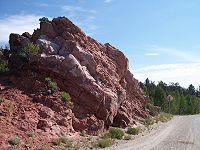
. Though unlabeled at the summit, it is identified by signs from both directions at the bottom. True to its name, red hills flank both sides of the summit and the inclines, especially on the south side. It is traversed by U.S. Highway 285 approximately 6 mi (10 km) northeast of the town of Fairplay
Fairplay, Colorado
The Town of Fairplay is a statutory town that is the county seat and the most populous town of Park County, Colorado, United States. Fairplay is located in South Park at an elevation of . The town is the fifth-highest incorporated place in the State of Colorado. The population was 610 at the...
, The pass is easily traversable by most motor vehicles and rarely closes in the winter.
External links
- Topographic map from USGS via Microsoft Research Maps

