Rasau
Encyclopedia
Rasau is an area in Brunei
. The area contains one of the two oil field
s of Brunei, the Rasau Field, and a small village, Kampong Rasau. The village located in the area has a population of 103.
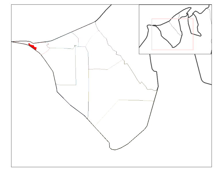
 Rasau is located in the Belait
district on the west bank of the Belait River south of Kampong Sungai Teraban
, close to the district capital of Kuala Belait
. It is one of the villages in Mukim Kuala Belait. It is located at 114º 11'E longtitude and 4º 34'N latitude. To the north lies Kampong Sungai Teraban. The Malaysian state of Sarawak
lies to the west and south with the Asam Paya oil field to the southwest. Across the Belait River to the east lies the southern portion of Kuala Belait and Kampong Sungai Duhon
.
Commercial hydrocarbons were first discovered in Rasau in 1979, and production began in 1983. A blowout of one of the wells in the Rasau Field, Rasau-17 occurred in April 1989. The resulting fire lasted from the 25th of April to the 8th of May when it was finally extinguished.
Rasau gain prominence in the latter half of the 20th century when a bridge was built across the Belait River providing a route to Miri
in Sarawak, Malaysia without the need for any ferry crossings across the Belait River. However, the bridge was not opened until after a family of Malaysians drowned at the ferry point during heavy rain.
s and fishermen.
The modern day Kampong Rasau serves as a suburb
of the nearby Kuala Belait. Villagers residing in Kampong Rasau can obtain a special permit to waive toll payment across the Rasau Bridge. This allows the villagers to conveniently travel across the Belait River for employment opportunities.
A shipyard, on the opposite bank from the Port of Kuala Belait at Kampong Sungai Duhon in Rasau, is a major source of employment for the people from the village and the greater Kuala Belait area.
in the Rasau area. However, some of the Rasau wells are on the east side of the Belait River in Kampong Sungai Duhon and Kampong Pandan.
The Rasau Production Station is located in the Rasau area. Pipelines connect it to the tank farms in Seria via Mumong and to the Refinery of Seria, via Kuala Belait.
Hydrocarbons from Malaysia's Asam Paya field in Sarawak, across the border from Rasau is piped into Rasau.
to the Malaysian border passes through Rasau. The road is a single carriageway and it is surfaced. It connects the Seria Bypass and the Rasau Bridge to the 11 km road between Kampong Sungai Teraban and Sungai Tujoh.
The Rasau Bridge across the Belait River is a toll bridge. The tolls ranges from B$
3 for a passenger car to over $20 for a commercial long vehicle. An unsurfaced road connects the village of Kampong Rasau to the Rasau bridge.
A "water taxi" can be hired at the public wharf close to the Kuala Belait market to go upriver towards Kampong Rasau and Kuala Balai.
There are no airports in the village. Commercial travellers would have to travel to either Bandar Seri Begawan or Miri to catch a commercial flight.
Brunei
Brunei , officially the State of Brunei Darussalam or the Nation of Brunei, the Abode of Peace , is a sovereign state located on the north coast of the island of Borneo, in Southeast Asia...
. The area contains one of the two oil field
Oil field
An oil field is a region with an abundance of oil wells extracting petroleum from below ground. Because the oil reservoirs typically extend over a large area, possibly several hundred kilometres across, full exploitation entails multiple wells scattered across the area...
s of Brunei, the Rasau Field, and a small village, Kampong Rasau. The village located in the area has a population of 103.
Location

Belait
Belait can refer to either:* the Belait District of Brunei Darussalam.* Kuala Belait, the administrative town of the Belait District* the Belait River which flows through the Belait District of Brunei Darussalam....
district on the west bank of the Belait River south of Kampong Sungai Teraban
Kampong Sungai Teraban
Kampong Sungai Teraban is a village in Brunei. It is located in the Belait district across the mouth of the Belait River from Kuala Belait and serves as a suburb of the latter. The current village has a population of 941.-Location:...
, close to the district capital of Kuala Belait
Kuala Belait
This article refers to the town of Kuala Belait. For the mukim of the same name, please refer to Kuala Belait, Belait. For district, please see Belait district.Kuala Belait |Jawi]]: )is a town located in South-West of Brunei...
. It is one of the villages in Mukim Kuala Belait. It is located at 114º 11'E longtitude and 4º 34'N latitude. To the north lies Kampong Sungai Teraban. The Malaysian state of Sarawak
Sarawak
Sarawak is one of two Malaysian states on the island of Borneo. Known as Bumi Kenyalang , Sarawak is situated on the north-west of the island. It is the largest state in Malaysia followed by Sabah, the second largest state located to the North- East.The administrative capital is Kuching, which...
lies to the west and south with the Asam Paya oil field to the southwest. Across the Belait River to the east lies the southern portion of Kuala Belait and Kampong Sungai Duhon
Kampong Sungai Duhon
Kampong Sungai Tujoh is a village that is located in the Belait district of Brunei. It is not known if the village was named after the river of Sungai Tujoh or vice versa...
.
History
Rasau was historically one of the first stops on the Belait River upriver from Kuala Belait towards the former district administrative capital of Kuala Balai. It was founded further inland from the mouth of the Belait River and Kuala Belait for protection against pirates.Commercial hydrocarbons were first discovered in Rasau in 1979, and production began in 1983. A blowout of one of the wells in the Rasau Field, Rasau-17 occurred in April 1989. The resulting fire lasted from the 25th of April to the 8th of May when it was finally extinguished.
Rasau gain prominence in the latter half of the 20th century when a bridge was built across the Belait River providing a route to Miri
Miri
Miri is a city in northern Sarawak, Malaysia, on the island of Borneo. It is the second largest city in Sarawak, with a population of about 300,000, and the government administrative centre of Miri District in Miri Division....
in Sarawak, Malaysia without the need for any ferry crossings across the Belait River. However, the bridge was not opened until after a family of Malaysians drowned at the ferry point during heavy rain.
Kampong Rasau
The small village of Kampong Rasau is located to the south of the Rasau Bridge. It has a population of 103 and is situated further upriver from Kuala Belait towards Kuala Balai. This was formerly a village of hunter-gathererHunter-gatherer
A hunter-gatherer or forage society is one in which most or all food is obtained from wild plants and animals, in contrast to agricultural societies which rely mainly on domesticated species. Hunting and gathering was the ancestral subsistence mode of Homo, and all modern humans were...
s and fishermen.
The modern day Kampong Rasau serves as a suburb
Suburb
The word suburb mostly refers to a residential area, either existing as part of a city or as a separate residential community within commuting distance of a city . Some suburbs have a degree of administrative autonomy, and most have lower population density than inner city neighborhoods...
of the nearby Kuala Belait. Villagers residing in Kampong Rasau can obtain a special permit to waive toll payment across the Rasau Bridge. This allows the villagers to conveniently travel across the Belait River for employment opportunities.
A shipyard, on the opposite bank from the Port of Kuala Belait at Kampong Sungai Duhon in Rasau, is a major source of employment for the people from the village and the greater Kuala Belait area.
Oil and gas
Rasau is dominated by the Rasau Field which is one of the two onshore oil fields in Brunei. The field is operated by Brunei Shell Petroleum and was discovered in 1979, although production from the field did not start until 1983. Most of the wells are located between the highway linking the Rasau Bridge to Sungai TujohSungai Tujoh
Sungai Tujoh, also abbreviated as Sg. Tujoh, is the westernmost point of Brunei. It is located in the Belait district . The name of the area is derived from two Bruneian Malay words - Sungai, which means river or stream, and Tujoh or the number seven...
in the Rasau area. However, some of the Rasau wells are on the east side of the Belait River in Kampong Sungai Duhon and Kampong Pandan.
The Rasau Production Station is located in the Rasau area. Pipelines connect it to the tank farms in Seria via Mumong and to the Refinery of Seria, via Kuala Belait.
Hydrocarbons from Malaysia's Asam Paya field in Sarawak, across the border from Rasau is piped into Rasau.
Transportation
The main highway from Bandar Seri BegawanBandar Seri Begawan
Bandar Seri Begawan, with an estimated population 140,000 , is the capital and largest city of the Sultanate of Brunei...
to the Malaysian border passes through Rasau. The road is a single carriageway and it is surfaced. It connects the Seria Bypass and the Rasau Bridge to the 11 km road between Kampong Sungai Teraban and Sungai Tujoh.
The Rasau Bridge across the Belait River is a toll bridge. The tolls ranges from B$
Brunei dollar
The ringgit Brunei or the Brunei dollar , has been the currency of the Sultanate of Brunei since 1967...
3 for a passenger car to over $20 for a commercial long vehicle. An unsurfaced road connects the village of Kampong Rasau to the Rasau bridge.
A "water taxi" can be hired at the public wharf close to the Kuala Belait market to go upriver towards Kampong Rasau and Kuala Balai.
There are no airports in the village. Commercial travellers would have to travel to either Bandar Seri Begawan or Miri to catch a commercial flight.

