
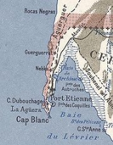
Ras Nouadhibou
Encyclopedia

Peninsula
A peninsula is a piece of land that is bordered by water on three sides but connected to mainland. In many Germanic and Celtic languages and also in Baltic, Slavic and Hungarian, peninsulas are called "half-islands"....
or headland
Headlands and bays
Headlands and bays are two related features of the coastal environment.- Geology and geography :Headlands and bays are often found on the same coastline. A bay is surrounded by land on three sides, whereas a headland is surrounded by water on three sides. Headlands are characterized by high,...
in the African coast of the Atlantic Ocean
Atlantic Ocean
The Atlantic Ocean is the second-largest of the world's oceanic divisions. With a total area of about , it covers approximately 20% of the Earth's surface and about 26% of its water surface area...
by the Tropic of Cancer
Tropic of Cancer
The Tropic of Cancer, also referred to as the Northern tropic, is the circle of latitude on the Earth that marks the most northerly position at which the Sun may appear directly overhead at its zenith...
. It is internationally known as Cap Blanc in French
French language
French is a Romance language spoken as a first language in France, the Romandy region in Switzerland, Wallonia and Brussels in Belgium, Monaco, the regions of Quebec and Acadia in Canada, and by various communities elsewhere. Second-language speakers of French are distributed throughout many parts...
or Cabo Blanco in Spanish
Spanish language
Spanish , also known as Castilian , is a Romance language in the Ibero-Romance group that evolved from several languages and dialects in central-northern Iberia around the 9th century and gradually spread with the expansion of the Kingdom of Castile into central and southern Iberia during the...
(both meaning "White Cape").
History
Portuguese sailing explorers first reached Cap Blanc in 1441. The Spanish originally claimed the land from 20° 51' N (near Cap Blanc) to 26° 8' N (near Cape BojadorCape Bojador
Cape Bojador or Cape Boujdour is a headland on the northern coast of Western Sahara, at 26° 07' 37"N, 14° 29' 57"W. , as well as the name of a nearby town with a population of 41,178.It is shown on nautical charts with the original Portuguese name "Cabo Bojador", but is sometimes...
) in 1885. This would be a protectorate governed from the Canary Islands
Canary Islands
The Canary Islands , also known as the Canaries , is a Spanish archipelago located just off the northwest coast of mainland Africa, 100 km west of the border between Morocco and the Western Sahara. The Canaries are a Spanish autonomous community and an outermost region of the European Union...
in 1887. France
France
The French Republic , The French Republic , The French Republic , (commonly known as France , is a unitary semi-presidential republic in Western Europe with several overseas territories and islands located on other continents and in the Indian, Pacific, and Atlantic oceans. Metropolitan France...
would later claim the Western Sahara. The boundary was settled in a joint French-Spanish convention in 1900 to divide the area between Spanish Sahara
Spanish Sahara
Spanish Sahara was the name used for the modern territory of Western Sahara when it was ruled as a territory by Spain between 1884 and 1975...
and French West Africa
French West Africa
French West Africa was a federation of eight French colonial territories in Africa: Mauritania, Senegal, French Sudan , French Guinea , Côte d'Ivoire , Upper Volta , Dahomey and Niger...
. However, the western side is currently occupied by Mauritania, as neither Morocco nor the Western Saharan Arab Republic is de-facto in possession.
A lighthouse
Ras Nouadhibou lighthouse
The Ras Nouadhibou lighthouse is a lighthouse located on Ras Nouadhibou in Mauritania. Constructed in 1910, it is today located only a few feet from Mauritania's border with Western Sahara. In recent years it appears to have been replaced with a modern fiberglass light structure...
was constructed on the cape in 1910.
Location
This thin stretch of land is now divided between MauritaniaMauritania
Mauritania is a country in the Maghreb and West Africa. It is bordered by the Atlantic Ocean in the west, by Western Sahara in the north, by Algeria in the northeast, by Mali in the east and southeast, and by Senegal in the southwest...
and the Western Sahara
Western Sahara
Western Sahara is a disputed territory in North Africa, bordered by Morocco to the north, Algeria to the northeast, Mauritania to the east and south, and the Atlantic Ocean to the west. Its surface area amounts to . It is one of the most sparsely populated territories in the world, mainly...
. On the western side, lies the Sahrawi
Western Sahara
Western Sahara is a disputed territory in North Africa, bordered by Morocco to the north, Algeria to the northeast, Mauritania to the east and south, and the Atlantic Ocean to the west. Its surface area amounts to . It is one of the most sparsely populated territories in the world, mainly...
town of Lagouira
Lagouira
La Güera or La Gouera is a town on the Atlantic coast at the southern tip of Western Sahara, on the western side of the Ras Nouadhibou peninsula...
; on the eastern side, less than a mile from the border, lies Mauritania's Nouadhibou
Nouadhibou
Nouadhibou is the second largest city in Mauritania and serves as a major commercial centre. The city itself has about 75,000 inhabitants expanding to over 90,000 in the larger metropolitan area. It is situated on a 40-mile peninsula or headland called Ras Nouadhibou, Cap Blanc, or Cabo Blanco, of...
(formerly Port Etienne).