
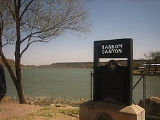
Ransom Canyon, Texas
Encyclopedia
Ransom Canyon is a town in Lubbock County of West Texas
, United States
. The population was 1,011 at the 2000 census. It is part of the Lubbock
Metropolitan Statistical Area
.
Ransom Canyon has some unusually designed homes, including the Lawson Rock House and the Steel House, both designed by Robert R. Bruno (1945-2008). The steel house was featured on an episode of Texas Country Reporter
with Bob Phillips
shortly before Bruno's death.
, at the eastern edge of the Llano Estacado
. Yellow House Canyon
was carved by the North Fork of the Double Mountain
Fork of the Brazos River
. This stream has been dammed multiple times to form Buffalo Springs Lake
and Lake Ransom Canyon.
According to the United States Census Bureau
, the town has a total area of 0.9 square miles (2.3 km²), of which, 0.8 square miles (2.1 km²) of it is land and 0.1 square mile (0.258998811 km²) of it (11.70%) is water.
of 2000, there were 1,011 people, 404 households, and 338 families residing in the town. The population density
was 1,213.1 people per square mile (470.3/km²). There were 412 housing units at an average density of 494.4/sq mi (191.7/km²). The racial makeup of the town was 95.25% White, 0.40% African American, 0.20% Native American, 0.40% Asian, 2.57% from other races
, and 1.19% from two or more races. Hispanic or Latino of any race were 4.85% of the population.
There were 404 households out of which 31.2% had children under the age of 18 living with them, 80.0% were married couples
living together, 3.2% had a female householder with no husband present, and 16.1% were non-families. 14.6% of all households were made up of individuals and 6.9% had someone living alone who was 65 years of age or older. The average household size was 2.50 and the average family size was 2.76.
In the town the population was spread out with 22.0% under the age of 18, 4.5% from 18 to 24, 23.5% from 25 to 44, 36.5% from 45 to 64, and 13.5% who were 65 years of age or older. The median age was 45 years. For every 100 females there were 94.4 males. For every 100 females age 18 and over, there were 90.6 males.
The median income for a household in the town was $78,427, and the median income for a family was $85,944. Males had a median income of $50,000 versus $34,500 for females. The per capita income
for the town was $45,675. None of the families and 0.6% of the population were living below the poverty line, including no under eighteens and 0.7% of those over 64.
and Slaton
Independent School Districts.
West Texas
West Texas is a vernacular term applied to a region in the southwestern quadrant of the United States that primarily encompasses the arid and semi-arid lands in the western portion of the state of Texas....
, United States
United States
The United States of America is a federal constitutional republic comprising fifty states and a federal district...
. The population was 1,011 at the 2000 census. It is part of the Lubbock
Lubbock, Texas
Lubbock is a city in and the county seat of Lubbock County, Texas, United States. The city is located in the northwestern part of the state, a region known historically as the Llano Estacado, and the home of Texas Tech University and Lubbock Christian University...
Metropolitan Statistical Area
Lubbock metropolitan area
The Lubbock Metropolitan Statistical Area is a metropolitan area in the South Plains region of Texas, USA, that covers two counties - Lubbock and Crosby. As of the 2000 census, the MSA had a population of 249,700...
.
Ransom Canyon has some unusually designed homes, including the Lawson Rock House and the Steel House, both designed by Robert R. Bruno (1945-2008). The steel house was featured on an episode of Texas Country Reporter
Texas Country Reporter
Texas Country Reporter is a weekly syndicated television program hosted and produced by Bob Phillips. It airs in all 22 Texas media markets, generally on weekends, and reruns are broadcast nationally on the satellite/cable channel RFD-TV...
with Bob Phillips
Bob Phillips
Robert Leon Phillips, known as Bob Phillips , is an American television journalist best known for his long-running program Texas Country Reporter...
shortly before Bruno's death.
Geography
The town of Ransom Canyon is located within Yellow House CanyonYellow House Canyon
Yellow House Canyon is a canyon that is about long, heading in Lubbock, Texas, at the junction of Blackwater Draw and Yellow House Draw, and trending generally southeastward to the edge of the Llano Estacado about east of Slaton, Texas; it forms one of three major canyons along the east side of...
, at the eastern edge of the Llano Estacado
Llano Estacado
Llano Estacado , commonly known as the Staked Plains, is a region in the Southwestern United States that encompasses parts of eastern New Mexico and northwestern Texas, including the South Plains and parts of the Texas Panhandle...
. Yellow House Canyon
Yellow House Canyon
Yellow House Canyon is a canyon that is about long, heading in Lubbock, Texas, at the junction of Blackwater Draw and Yellow House Draw, and trending generally southeastward to the edge of the Llano Estacado about east of Slaton, Texas; it forms one of three major canyons along the east side of...
was carved by the North Fork of the Double Mountain
Double Mountain (Texas)
Double Mountain is the name of a pair of flat-topped buttes located southwest of Aspermont in Stonewall County, Texas. While the Handbook of Texas gives their elevation as either or , United States Geological Survey maps give the elevation of the western mountain as and that of the eastern...
Fork of the Brazos River
Brazos River
The Brazos River, called the Rio de los Brazos de Dios by early Spanish explorers , is the longest river in Texas and the 11th longest river in the United States at from its source at the head of Blackwater Draw, Curry County, New Mexico to its mouth at the Gulf of Mexico with a drainage...
. This stream has been dammed multiple times to form Buffalo Springs Lake
Buffalo Springs, Texas
Buffalo Springs is a village in Lubbock County, Texas, United States. The population was 493 at the 2000 census. It is part of the Lubbock Metropolitan Statistical Area.-Geography:Buffalo Springs is located at ....
and Lake Ransom Canyon.
According to the United States Census Bureau
United States Census Bureau
The United States Census Bureau is the government agency that is responsible for the United States Census. It also gathers other national demographic and economic data...
, the town has a total area of 0.9 square miles (2.3 km²), of which, 0.8 square miles (2.1 km²) of it is land and 0.1 square mile (0.258998811 km²) of it (11.70%) is water.
Demographics
As of the censusCensus
A census is the procedure of systematically acquiring and recording information about the members of a given population. It is a regularly occurring and official count of a particular population. The term is used mostly in connection with national population and housing censuses; other common...
of 2000, there were 1,011 people, 404 households, and 338 families residing in the town. The population density
Population density
Population density is a measurement of population per unit area or unit volume. It is frequently applied to living organisms, and particularly to humans...
was 1,213.1 people per square mile (470.3/km²). There were 412 housing units at an average density of 494.4/sq mi (191.7/km²). The racial makeup of the town was 95.25% White, 0.40% African American, 0.20% Native American, 0.40% Asian, 2.57% from other races
Race (United States Census)
Race and ethnicity in the United States Census, as defined by the Federal Office of Management and Budget and the United States Census Bureau, are self-identification data items in which residents choose the race or races with which they most closely identify, and indicate whether or not they are...
, and 1.19% from two or more races. Hispanic or Latino of any race were 4.85% of the population.
There were 404 households out of which 31.2% had children under the age of 18 living with them, 80.0% were married couples
Marriage
Marriage is a social union or legal contract between people that creates kinship. It is an institution in which interpersonal relationships, usually intimate and sexual, are acknowledged in a variety of ways, depending on the culture or subculture in which it is found...
living together, 3.2% had a female householder with no husband present, and 16.1% were non-families. 14.6% of all households were made up of individuals and 6.9% had someone living alone who was 65 years of age or older. The average household size was 2.50 and the average family size was 2.76.
In the town the population was spread out with 22.0% under the age of 18, 4.5% from 18 to 24, 23.5% from 25 to 44, 36.5% from 45 to 64, and 13.5% who were 65 years of age or older. The median age was 45 years. For every 100 females there were 94.4 males. For every 100 females age 18 and over, there were 90.6 males.
The median income for a household in the town was $78,427, and the median income for a family was $85,944. Males had a median income of $50,000 versus $34,500 for females. The per capita income
Per capita income
Per capita income or income per person is a measure of mean income within an economic aggregate, such as a country or city. It is calculated by taking a measure of all sources of income in the aggregate and dividing it by the total population...
for the town was $45,675. None of the families and 0.6% of the population were living below the poverty line, including no under eighteens and 0.7% of those over 64.
Education
Ransom Canyon is served by the RooseveltRoosevelt Independent School District
Roosevelt Independent School District is a small, innovative, public school district located 8 miles east of Lubbock, Texas .The district serves the unincorporated communities of Acuff and Roosevelt along with the incorporated towns of Buffalo Springs and Ransom Canyon...
and Slaton
Slaton Independent School District
Slaton Independent School District is a public school district based in Slaton, Texas .In addition to Slaton, the district serves students in rural southeastern Lubbock County and parts of Ransom Canyon...
Independent School Districts.
See also
- Yellow House CanyonYellow House CanyonYellow House Canyon is a canyon that is about long, heading in Lubbock, Texas, at the junction of Blackwater Draw and Yellow House Draw, and trending generally southeastward to the edge of the Llano Estacado about east of Slaton, Texas; it forms one of three major canyons along the east side of...
- Buffalo Springs, TexasBuffalo Springs, TexasBuffalo Springs is a village in Lubbock County, Texas, United States. The population was 493 at the 2000 census. It is part of the Lubbock Metropolitan Statistical Area.-Geography:Buffalo Springs is located at ....
- Llano EstacadoLlano EstacadoLlano Estacado , commonly known as the Staked Plains, is a region in the Southwestern United States that encompasses parts of eastern New Mexico and northwestern Texas, including the South Plains and parts of the Texas Panhandle...
- Caprock EscarpmentCaprock EscarpmentThe Caprock Escarpment is a term used in Texas and Eastern New Mexico to describe the geographical transition point between the level elevated plains of the Llano Estacado and the surrounding rolling terrain. In Texas, the escarpment stretches around 320 km south-southwest from the northeast...
- Double Mountain Fork Brazos RiverDouble Mountain Fork Brazos RiverThe Double Mountain Fork Brazos River is an ephemeral, sandy-braided stream about long, heading on the Llano Estacado of West Texas about southeast of Tahoka, Texas, flowing east-northeast across the western Rolling Plains to join the Salt Fork, forming the Brazos River about west-northwest of...
- Yellow House DrawYellow House DrawYellow House Draw is an ephemeral watercourse about long, heading about north of Morton, Texas, and tending generally east-southeastward across the Llano Estacado to the city of Lubbock where it joins Blackwater Draw to form Yellow House Canyon at the head of the North Fork Double Mountain Fork...