

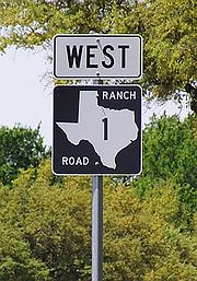
Ranch Road 1
Encyclopedia
Texas
Texas is the second largest U.S. state by both area and population, and the largest state by area in the contiguous United States.The name, based on the Caddo word "Tejas" meaning "friends" or "allies", was applied by the Spanish to the Caddo themselves and to the region of their settlement in...
maintained by the Texas Department of Transportation (TxDOT)
Texas Department of Transportation
The Texas Department of Transportation is a governmental agency in the U.S. state of Texas. Its stated mission is to "work cooperatively to provide safe, effective and efficient movement of people and goods" throughout the state...
. The 6.6 miles (10.6 km) route begins at U.S. Route 290
U.S. Route 290
U.S. Highway 290 is an east–west U.S. Highway located entirely within the State of Texas. Its current western terminus is at Interstate 10 milepost 477 , southeast of Junction, and its eastern terminus is at Interstate 610 on the northwest side of Houston.-Route Description:West of Austin, U.S...
in Stonewall
Stonewall, Texas
Stonewall is a census-designated place in Gillespie County, Texas, United States. The population was 469 at the 2000 census. It was named for Thomas J. Jackson, by Israel P. Nunez, who established a stage station near the site in 1870....
in Gillespie County
Gillespie County, Texas
Gillespie County is a county located on the Edwards Plateau in the U.S. state of Texas. In 2010, its population was 24,837. It is located in the heart of the Texas Hill Country. Gillespie is named for Robert Addison Gillespie, who came to Texas in 1837. He was a Texas Ranger, an Indian fighter, a...
and runs along the Pedernales River
Pedernales River
The Pedernales River is a tributary of the Colorado River, approximately long, in central Texas in the United States. It drains an area of the Edwards Plateau, flowing west to east across the Texas Hill Country west of Austin...
through Lyndon B. Johnson National Historical Park
Lyndon B. Johnson National Historical Park
Lyndon B. Johnson National Historical Park is a United States National Historical Park in central Texas about 50 miles west of Austin in the Texas Hill Country. The park protects the birthplace, home, ranch and final resting place of Lyndon B. Johnson, 36th President of the United States...
, the late President Lyndon Johnson's
Lyndon B. Johnson
Lyndon Baines Johnson , often referred to as LBJ, was the 36th President of the United States after his service as the 37th Vice President of the United States...
former ranch, and through Lyndon B. Johnson State Park and Historic Site
Lyndon B. Johnson State Park and Historic Site
Lyndon B. Johnson State Park and Historic Site is a state park located along the Pedernales River in Gillespie County, Texas, United States west of Johnson City and east of Fredericksburg. The state created the park with donated land to honor Lyndon B...
before terminating at US 290 near Hye
Hye, Texas
Hye is an unincorporated community in western Blanco County, Texas, United States. It lies along U.S. Route 290 west of the city of Johnson City, the county seat of Blanco County. Its elevation is 1,453 feet . Although Hye is unincorporated, it has a post office, with the ZIP code of...
in Blanco County
Blanco County, Texas
Blanco County is a county located on the Edwards Plateau in the U.S. state of Texas. As of 2010, the population is 10,497. Its county seat is Johnson City. Blanco is named for the Blanco River which traverses the county. The State of Texas formed Blanco County in 1858 from portions of Burnet,...
. The road, designated in 1963, is the only road in the state that TxDOT has designated as a Ranch Road. The road has intersections with Ranch to Market Road 1623
Ranch to Market Road 1623
Ranch to Market Road 1623 is a farm to market road in Gillespie and Blanco counties, Texas.-Route description:RM 1623 begins in eastern Gillespie County at an intersection with . It travels to the south into Stonewall, where it crosses Ranch Road 1, and has a one-block eastward concurrency with ...
and Park Road 49. In the earliest days of the state highway system
Texas state highways
Texas state highways are a network of highways owned and maintained by the U.S. state of Texas. The Texas Department of Transportation is the state agency responsible for the day-to-day operations and maintenance of the system. In addition to the nationally-numbered Interstate highways and U.S...
, the route was a part of State Highway 20 and later part of US 290 before that highway was relocated to the south.
History
Ranch Road 1 was designated on December 19, 1963, 27 days after Lyndon Johnson was sworn in as president, from its current western terminus at US 290 near Stonewall to a point 1.2 miles (1.9 km) west of the county line between Gillespie and Blanco counties. The following year, the road was extended 2.1 miles (3.4 km) eastward to its present terminus near Hye. The route was originally part of SH 20. In 1935, US 290 was routed over the road, and the SH 20 designation was dropped in the 1939 general redescription of the state highway system. US 290 was rerouted south to its current location sometime between 1941 and 1961.Route description
Ranch Road 1 is classified by TxDOT as a Ranch Road and is the only highway in the state to be so categorized. The route is not considered a part of the state's Farm and Ranch to Market Road System despite being signed with a shield similar to Ranch to Market Roads and the common practice of referring to Ranch to Market Roads as "Ranch Roads" colloquially if not officially. However, it may actually be a recreational road.Ranch Road 1 begins at US 290 on the west side of Stonewall. The two-lane road follows along the south bank of the Pedernales River around the town's north side and intersects RM 1623 on the town's east side. The route continues along the river briefly passing through a narrow southwestern portion of Lyndon B. Johnson National Historic Site before entering Lyndon B Johnson State Park and Historic Site. The route crosses the length of the state park at its northern edge along the riverbank and exits the park before intersecting PR 49 which crosses the river accessing the national historic site. After crossing into Blanco County, the route turns away from the riverbank to the southeast returning to SH 290 west of Hye. Although the road is located in the Texas Hill Country
Texas Hill Country
The Texas Hill Country is a vernacular term applied to a region of Central Texas featuring tall rugged hills consisting of thin layers of soil atop limestone or granite. It also includes the Llano Uplift and the second largest granite monadnock in the United States, Enchanted Rock, which is located...
, the road only encounters gentle grades within the channel of the Pedernales River.